January 23, 2016

Cyclone Corentin Forms in South-West Indian Ocean

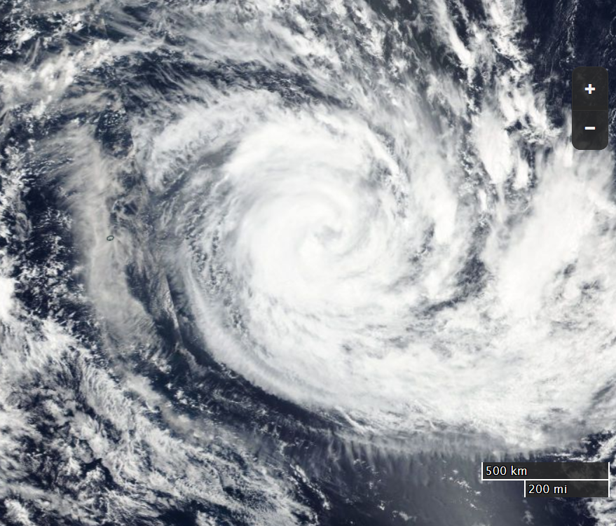
We've already reported on unusually early hurricanes in the North Atlantic and North Pacific. Now comes news of the first Southern Hemisphere cyclone of 2016. Yesterday the Joint Typhoon Warning Center in Hawaii reported that Cyclone Corentin had developed hurricane force winds in the South-West Indian Ocean. Of course it's summer in the Southern Hemisphere, so this event is unusual for a different reason. Corentin is the first storm of the 2015-16 season to reach category 1 strength, and has done so later than in previous years.

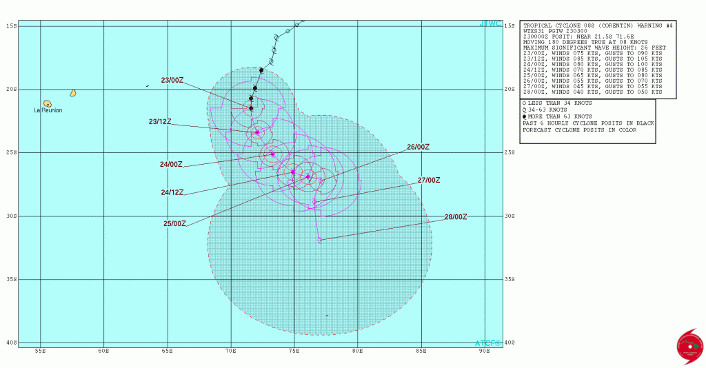
Here's the JTWC's current forecast track for Corentin, showing Reunion Island well to the west of the cyclone:

Here's an extract from the JTWC's latest bulletin:

230300Z POSITION NEAR 22.0S 71.7E.

TROPICAL CYCLONE 08S (CORENTIN), LOCATED APPROXIMATELY 866 NM SOUTH OF DIEGO GARCIA, HAS TRACKED SOUTHWARD AT 08 KNOTS OVER THE PAST SIX HOURS.

ANIMATED ENHANCED INFRARED SATELLITE IMAGERY DEPICTS CONVECTIVE BANDS WRAPPING TIGHTLY INTO A LOW-LEVEL CIRCULATION CENTER.

A 222310Z SSMIS 91 GHZ IMAGE DEPICTS A WELL-DEFINED MICROWAVE EYE FEATURE WITH CONVECTION COMPLETELY SURROUNDING THE CENTER. PGTW AND KNES DVORAK INTENSITY ANALYSES YIELDED T-NUMBERS OF 4.5 AND SUPPORT THE INITIAL INTENSITY
OF 75 KNOTS.

TC CORENTIN REMAINS IN AN AREA FAVORABLE FOR SLIGHT INTENSIFICATION WITH LOW (5 TO 10 KNOTS) VERTICAL WIND SHEAR (VWS) A STRONG POLEWARD OUTFLOW CHANNEL AND HIGH (28 DEG C) SEA SURFACE TEMPERATURES (SSTS)

TC 08S IS EXPECTED TO REACH PEAK INTENSITY BY TAU 12 THEN BEGIN A SLOW WEAKENING TREND THROUGH THE REMAINDER OF THE FORECAST PERIOD IN RESPONSE TO INCREASED VWS AND DECREASING SSTS. BY TAU 120, TC CORENTIN WILL BEGIN EXTRA-TROPICAL TRANSITION AS IT INTERACTS WITH A MID-LATITUDE FRONTAL SYSTEM AND UPPER-LEVEL TROUGH.

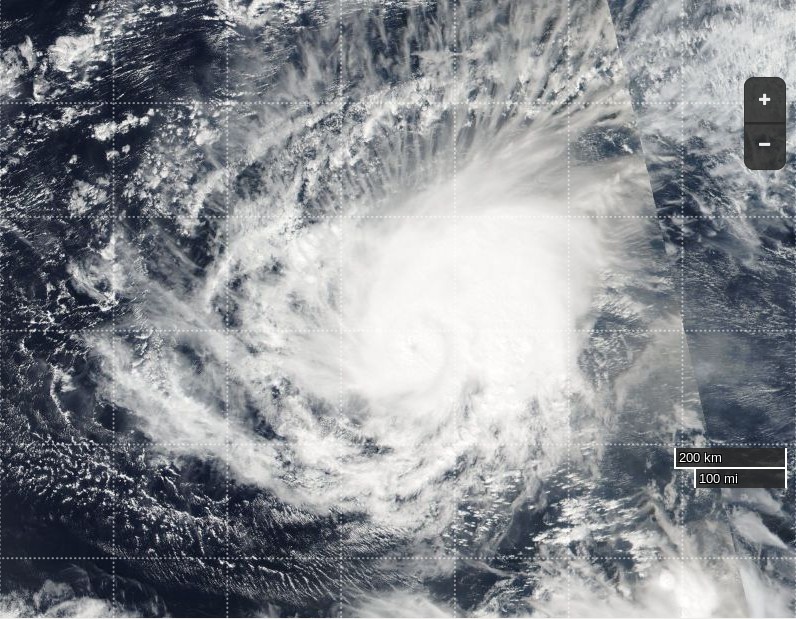
and here's how Corentin looked from NASA's Suomi satellite yesterday:

Filed under Climate by
January 21, 2016

Winter Storm Jonas Potentially Crippling for Washington DC

The "Blizzard Watch" we reported on this morning has now been upgraded to a "Blizzard Warning" by the United States' National Weather Service. The NWS home page currently warns that:

A potentially crippling winter storm is anticipated for portions of the mid-Atlantic Friday into early Saturday. Snowfall may approach two feet for some locations, including the Baltimore and Washington, DC, metro areas. Farther north, there is uncertainty in snowfall for the New York City-to-Boston corridor. Farther south, significant icing is likely for portions of Kentucky and North Carolina.

The latest update from NWS Washingtom DC states that:

URGENT – WINTER WEATHER MESSAGE
NATIONAL WEATHER SERVICE BALTIMORE MD/WASHINGTON DC
1209 PM EST THU JAN 21 2016

BLIZZARD WARNING IN EFFECT FROM 3 PM FRIDAY TO 6 AM EST SUNDAY.

THE NATIONAL WEATHER SERVICE IN BALTIMORE MD/WASHINGTON HAS ISSUED A BLIZZARD WARNING WHICH IS IN EFFECT FROM 3 PM FRIDAY TO 6 AM EST SUNDAY. THE BLIZZARD WATCH IS NO LONGER IN EFFECT.

* HAZARD TYPES…HEAVY SNOW AND WIND WITH BLOWING AND DRIFTING SNOW FRIDAY AFTERNOON THROUGH SATURDAY NIGHT. SLEET MAY MIX WITH THE SNOW FRIDAY NIGHT INTO SATURDAY MORNING EAST OF INTERSTATE 95 BEFORE CHANGING BACK TO ALL SNOW BY SATURDAY AFTERNOON.

* ACCUMULATIONS…SNOW ACCUMULATION OF 18 TO 24 INCHES IN THE EASTERN SUBURBS OF WASHINGTON DC AND 24 TO 30 INCHES IN THE WESTERN SUBURBS. THE CITY OF WASHINGTON DC IS EXPECTED TO RECEIVE AROUND 24 INCHES.

* TIMING…HEAVY SNOW WILL DEVELOP LATE FRIDAY AFTERNOON AND CONTINUE THROUGH SATURDAY NIGHT. CONDITIONS ARE EXPECTED TO DETERIORATE FRIDAY AFTERNOON WITH THE HEAVIEST SNOW. STRONGEST WINDS…AND POTENTIAL LIFE THREATENING CONDITIONS EXPECTED FRIDAY NIGHT THROUGH SATURDAY.

* IMPACTS…HEAVY SNOW AND BLOWING SNOW WILL CAUSE DANGEROUS CONDITIONS AND WILL BE A THREAT TO LIFE AND PROPERTY. TRAVEL IS EXPECTED TO BE SEVERELY LIMITED IF NOT IMPOSSIBLE DURING THE HEIGHT OF THE STORM FRIDAY NIGHT AND SATURDAY. VISIBILITY WILL BE REDUCED TO NEAR ZERO AT TIMES IN WHITEOUT CONDITIONS.

* WINDS…NORTHEAST 25 TO 35 MPH WITH GUSTS UP TO 50 MPH. BECOMING NORTH SATURDAY.

* TEMPERATURES…MID TO UPPER 20S.

PRECAUTIONARY/PREPAREDNESS ACTIONS…A BLIZZARD WARNING MEANS SEVERE WINTER WEATHER CONDITIONS ARE EXPECTED OR OCCURRING. FALLING AND BLOWING SNOW WITH STRONG WINDS AND POOR VISIBILITIES ARE LIKELY. THIS WILL LEAD TO WHITEOUT CONDITIONS, MAKING TRAVEL EXTREMELY DANGEROUS. DO NOT TRAVEL. IF YOU MUST TRAVEL HAVE A WINTER SURVIVAL KIT WITH YOU. IF YOU GET STRANDED STAY WITH YOUR VEHICLE. PREPARE FOR THE POSSIBILITY OF POWER OUTAGES DURING SNOWY AND COLD CONDITIONS.

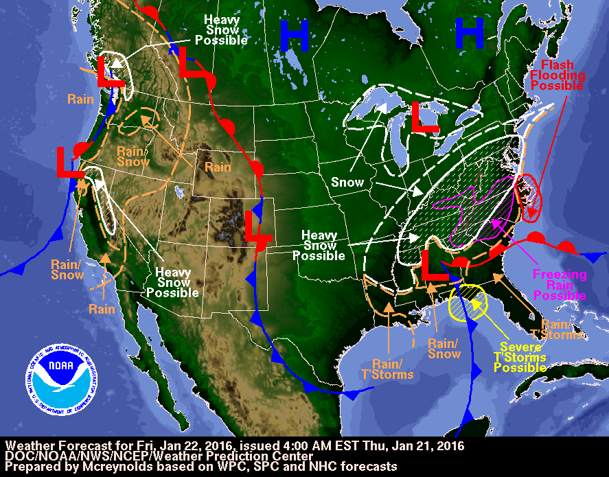
Here is the NWS Weather Prediction Center forecast map for tomorrow:

Note that apart from all the snow and freezing rain it forecasts "possible flash flooding" on the east coast.

Filed under Climate by

January 19, 2016

Two Pairs of Hurricane Force Storms

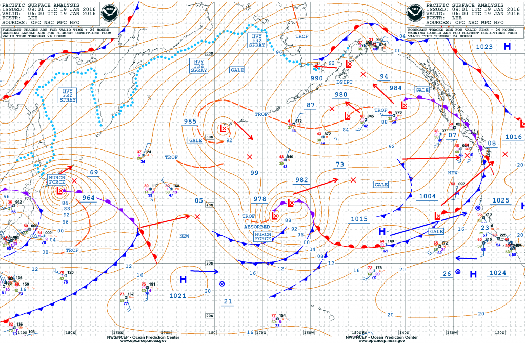
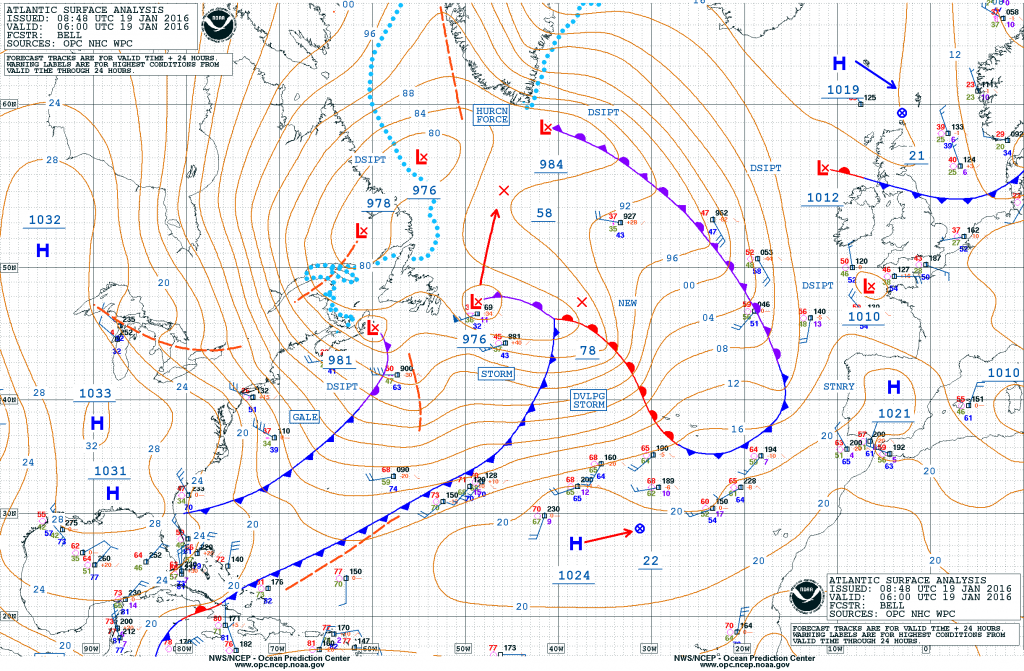
The Ocean Prediction Center of the United States' National Weather Service highlighted this unusual situation on their Twitter feed yesterday:

Four hurricane force lows in the two ocean basins within the next 24 hours!

Let's see how that prediction has worked out. Here's the OPC's current synopsis for the North Pacific:

and here's the equivalent for the North Atlantic:

There's obviously two hurricane force systems in the Pacific, but the OPC "high seas" bulletin for the Atlantic has this to say this morning:

HURRICANE FORCE WIND WARNING…

LOW 56N52W 982 MB MOVING NW 10 KT. FRONT EXTENDS FROM LOW CENTER TO 57N42W TO 56N35W.
FROM 58N TO 60N BETWEEN 42W AND 49W. WINDS 50 TO 65 KT. SEAS 21 TO 28 FT.
ELSEWHERE FROM 58N TO 60N BETWEEN 37W AND 52W WINDS 40 TO 50 KT. SEAS 19 TO 24 FT.
ALSO WITHIN 240 NM NW AND N OF THE FRONT WINDS 25 TO 40 KT. SEAS 12 TO 20 FT.

24 HOUR FORECAST LOW DISSIPATED. N OF A FRONT TO EXTEND FROM 60N44W TO 59N35W WINDS 25 TO 35 KT. SEAS 11 TO 18 FT.

48 HOUR FORECAST CONDITIONS DIMINISHED.

and also this:

HURRICANE FORCE WIND WARNING…

24 HOUR FORECAST NEW LOW 41N45W 990 MB. FRONT TO EXTEND FROM LOW CENTER TO 37N59W TO 36N67W. WITHIN 120 NM SE OF THE FRONT. WINDS 40 TO 50 KT. SEAS 18 TO 28 FT.
ELSEWHERE OVER FORECAST WATERS WITHIN 600 NM SE…1500 NM SW…AND 660 NM NW QUADRANTS. WINDS 25 TO 40 KT. SEAS 12 TO 24 FT.

48 HOUR FORECAST LOW 57N36W 956 MB. BETWEEN 60 NM AND 120 NM N AND S QUADRANTS WINDS 50 TO 65 KT. SEAS 17 TO 26 FT.
ELSEWHERE WITHIN 180 NM N AND S QUADRANTS WINDS 40 TO 50 KT. SEAS 16 TO 20 FT. ALSO WITHIN 300 NM OF CENTER…EXCEPT 180 NM SW QUADRANT WINDS 25 TO 40 KT. SEAS 15 TO 18 FT.

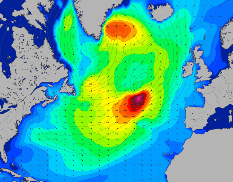
Two separate hurricane force systems then, but whether they'll be simultaneously producing winds of that strength remains to be seen. Nonetheless, here is Magic Seaweed's surf forecast for the North Atlantic on Thursday afternoon:

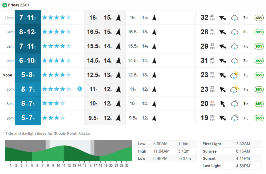
One large swell heading for Southern Greenland, and another one heading straight for Soggy South West England! Meanwhile over in the Pacific surfers in Alaska have this to look forward too later in the week:

As far as I can ascertain Magic Seaweed don't produce a surf forecast for Greenland!

Filed under Climate by

January 15, 2016

Hurricane Alex Heads for Greenland

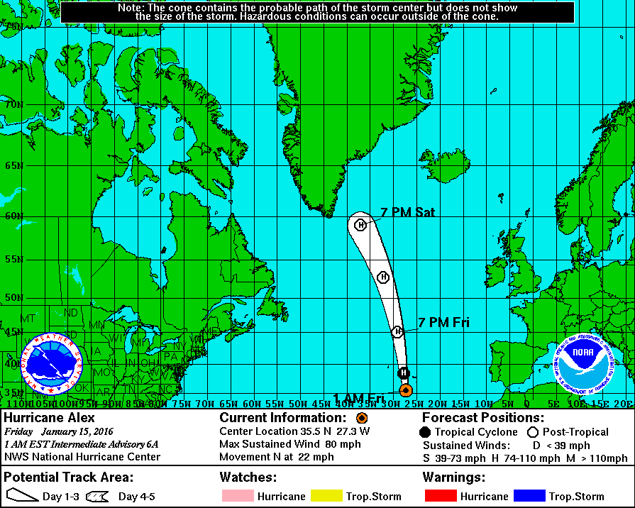
As we previously reported the extraordinary North Atlantic cyclone called Alex became a hurricane yesterday. This morning (UTC) we wake to discover that in their most recent update on his progress the National Hurricane Center are predicting that even though Alex has now weakened slightly he will carry his hurricane force winds all the way to Greenland:

According to their interim bulletin 6A:

CONDITIONS [ARE] DETERIORATING OVER THE CENTRAL AND EASTERN AZORES…
HURRICANE CONDITIONS EXPECTED OVER PORTIONS OF THE AZORES LATER
THIS MORNING…

SUMMARY OF 200 AM AST…0600 UTC…INFORMATION
———————————————-
LOCATION…35.5N 27.3W
ABOUT 220 MI…355 KM S OF TERCEIRA ISLAND IN THE CENTRAL AZORES
ABOUT 230 MI…365 KM SSE OF FAIAL ISLAND IN THE CENTRAL AZORES
MAXIMUM SUSTAINED WINDS…80 MPH…130 KM/H
PRESENT MOVEMENT…N OR 10 DEGREES AT 22 MPH…35 KM/H
MINIMUM CENTRAL PRESSURE…984 MB…29.06 INCHES

The more detailed discussion from 3 hours earlier points out that:

The cyclone should begin extratropical transition in the next few hours, and the global models suggest there will be enough baroclinic forcing to maintain hurricane-force winds through and after the transition despite the cold water.

Based on this and input from the Ocean Prediction Center, the new intensity forecast shows little change in strength until Alex is absorbed by a large extratropical low in about 72 hours.

Filed under Climate by

January 13, 2016

Subtropical Storm Alex Arrives in the North Atlantic

Further to our recent news about the unseasonally early formation of Hurricane Pali in the Pacific the National Hurricane Center has just announced that:

OUT OF SEASON SUBTROPICAL STORM FORMS OVER THE FAR EASTERN
ATLANTIC…

SUMMARY OF 500 PM AST…2100 UTC…INFORMATION
———————————————-
LOCATION…27.1N 30.8W
ABOUT 785 MI…1260 KM SSW OF THE AZORES
MAXIMUM SUSTAINED WINDS…50 MPH…85 KM/H
PRESENT MOVEMENT…NE OR 55 DEGREES AT 14 MPH…22 KM/H
MINIMUM CENTRAL PRESSURE…990 MB…29.24 INCHES

The NHC's forecast discussion concerning Alex adds that:

The cyclone is co-located with an upper-level low, and appears to have only a weak warm core, so it is being designated as a subtropical storm.

By 96 hours, the global models show the cyclone merging or becoming absorbed by another extratropical low at high latitudes.

Alex is the first tropical or subtropical storm to form in January since an unnamed system did so in 1978, and is only the fourth known to form in this month in the historical record that begins in 1851.

The NHC suggests that, unlike Pali, Alex may pass near some human habitations:

WATCHES AND WARNINGS
——————–
Interests in the Azores should monitor the progress of Alex.

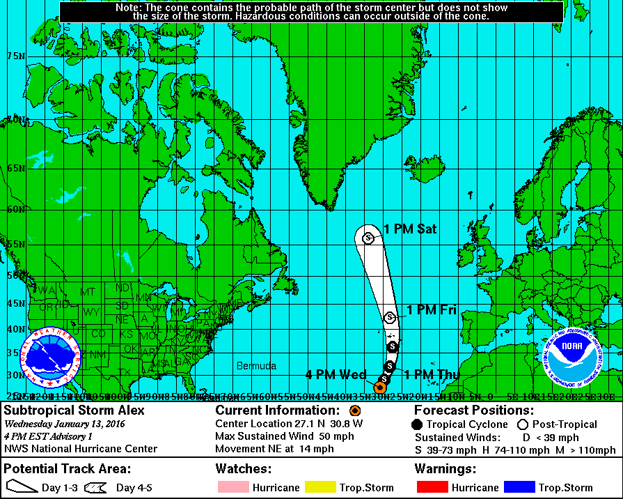
Here's Alex's current forecast track for the next 5 days:

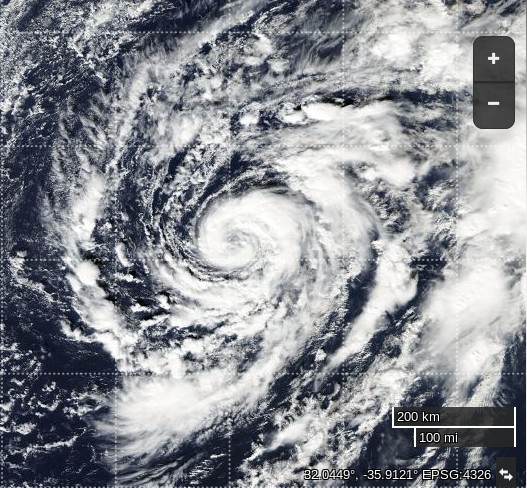
and here's an image of Alex courtesy of NASA's Aqua satellite, at the same scale as our picture of Pali yesterday:

Filed under Climate by
January 12, 2016

Pali in Early Start to 2016 Pacific Cyclone Season

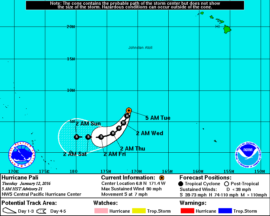
In an extremely early start to the 2016 Pacific Cyclone Season the Central Pacific Hurricane Center announced early this morning that Hurricane Pali had reached category 1 strength. They currently report that:

AT 500 AM HST…1500 UTC…THE CENTER OF HURRICANE PALI WAS LOCATED NEAR LATITUDE 6.8 NORTH…LONGITUDE 171.4 WEST. PALI IS MOVING TOWARD THE SOUTH NEAR 7 MPH. THIS MOTION IS EXPECTED TO CONTINUE TODAY…FOLLOWED BY A GRADUAL TURN TOWARD THE SOUTHWEST THROUGH THURSDAY MORNING.

MAXIMUM SUSTAINED WINDS ARE NEAR 90 MPH…150 KM/H…WITH HIGHER GUSTS. SLOW WEAKENING IS EXPECTED THROUGH THURSDAY MORNING.

HURRICANE FORCE WINDS EXTEND OUTWARD UP TO 25 MILES…35 KM…FROM THE CENTER…AND TROPICAL STORM FORCE WINDS EXTEND OUTWARD UP TO 105 MILES…165 KM.

THE ESTIMATED MINIMUM CENTRAL PRESSURE IS 979 MB…28.91 INCHES.

Here is Pali's forecast track over the next few days:

Fortunately that means the CPHC are able to add that:

HAZARDS AFFECTING LAND
———————-
NONE.

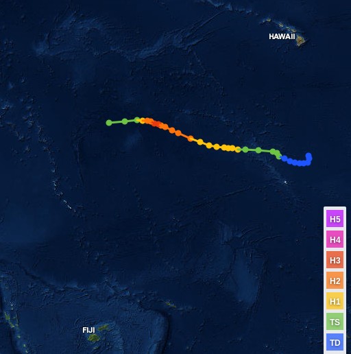
According to NOAA's database of hurricanes the previous earliest hurricane in the Central Pacific was Ekeka which achieved hurricane force on January 31st 1992:

In all the circumstances perhaps the CPHC need to update their website though? It currently states:

The Eastern Pacific Hurricane season runs from May 15 to November 30.
The Central North Pacific hurricane season officially ended on November 30th. We will resume issuing tropical weather outlooks starting on June 1st of 2016.

P.S. Here's a picture of Pali on the evening of January 12th, courtesy of NASA's Suomi satellite:

The latest CPHC update states:

SUMMARY OF 1100 AM HST…2100 UTC…INFORMATION
———————————————–
LOCATION…6.2N 171.3W
ABOUT 735 MI…1185 KM S OF JOHNSTON ISLAND
ABOUT 1375 MI…2210 KM SW OF HONOLULU HAWAII
MAXIMUM SUSTAINED WINDS…100 MPH…155 KM/H
PRESENT MOVEMENT…SSW OR 200 DEGREES AT 7 MPH…11 KM/H
MINIMUM CENTRAL PRESSURE…977 MB…28.85 INCHES

Filed under Climate by

August 31, 2015

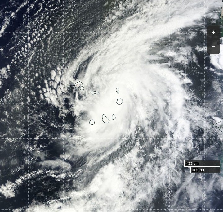
Hurricane Fred Threatens Cape Verde Islands

Way back on May 9th we reported on an unusually early start to the 2015 Atlantic Hurricane Season. Things have been fairly quiet since then. There have been a few named tropical storms, one of which became Hurricane Danny on August 20th. Danny didn't pose much threat to life and limb, but another unusual tropical storm is about to change that. At 06:00 UTC this morning the National Hurricane Centre advised that:

FRED BECOMES A HURRICANE AS IT MOVES CLOSER TO THE EASTERNMOST CAPE VERDE ISLANDS.

LOCATION…15.3N 22.5W

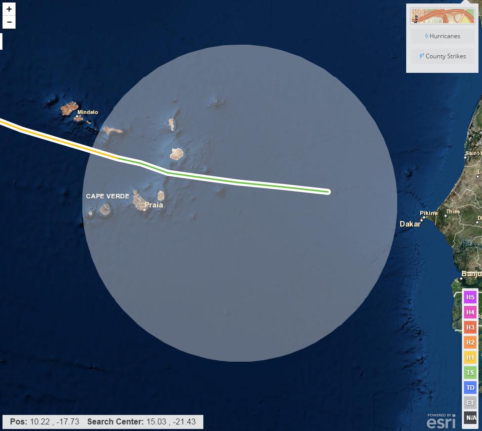
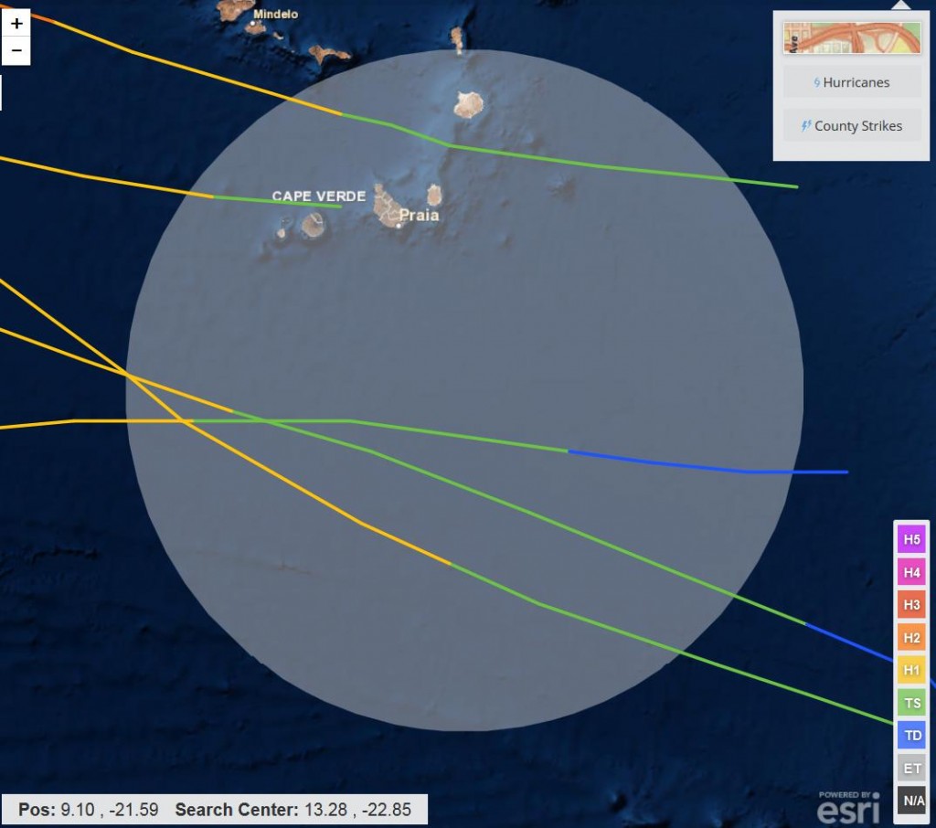
Fred is unusual because he's still so close to the African coast. It's very rare for an Atlantic hurricane to form at a longitude east of 35 degrees west. The only one that formed in the area that I can find in NOAA's historical records is an unnamed hurricane from September 1892 that reached hurricane force over the islands:

The 09:00 UTC bulletin from the NHC reports that:

HURRICANE FRED CONTINUES TO STRENGTHEN AS IT MOVES THROUGH THE EASTERNMOST CAPE VERDE ISLANDS…

LOCATION…15.6N 22.9W
ABOUT 35 MI…55 KM S OF RABIL IN THE CAPE VERDE ISLANDS
ABOUT 65 MI…100 KM NE OF PRAIA IN THE CAPE VERDE ISLANDS
MAXIMUM SUSTAINED WINDS…80 MPH…130 KM/H
PRESENT MOVEMENT…NW OR 305 DEGREES AT 12 MPH…19 KM/H
MINIMUM CENTRAL PRESSURE…989 MB…29.21 INCHES

A Hurricane Warning is in effect for the Cape Verde Islands

A Hurricane Warning means that hurricane conditions are expected
somewhere within the warning area, in this case within the next 6
to 12 hours. Preparations to protect life and property should be
rushed to completion.

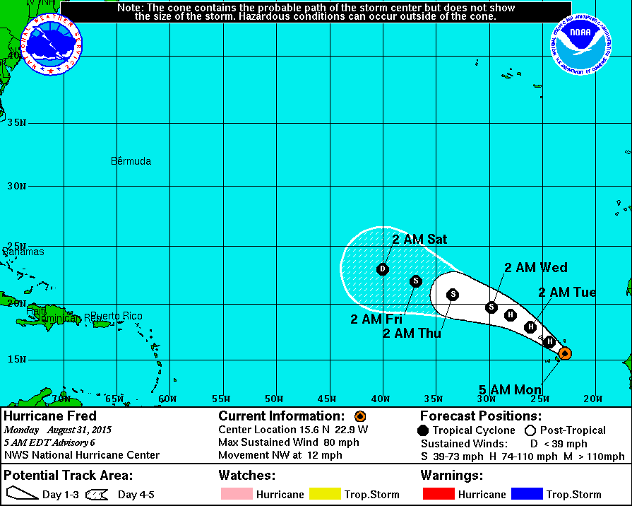
Here's Fred's current forecast track:

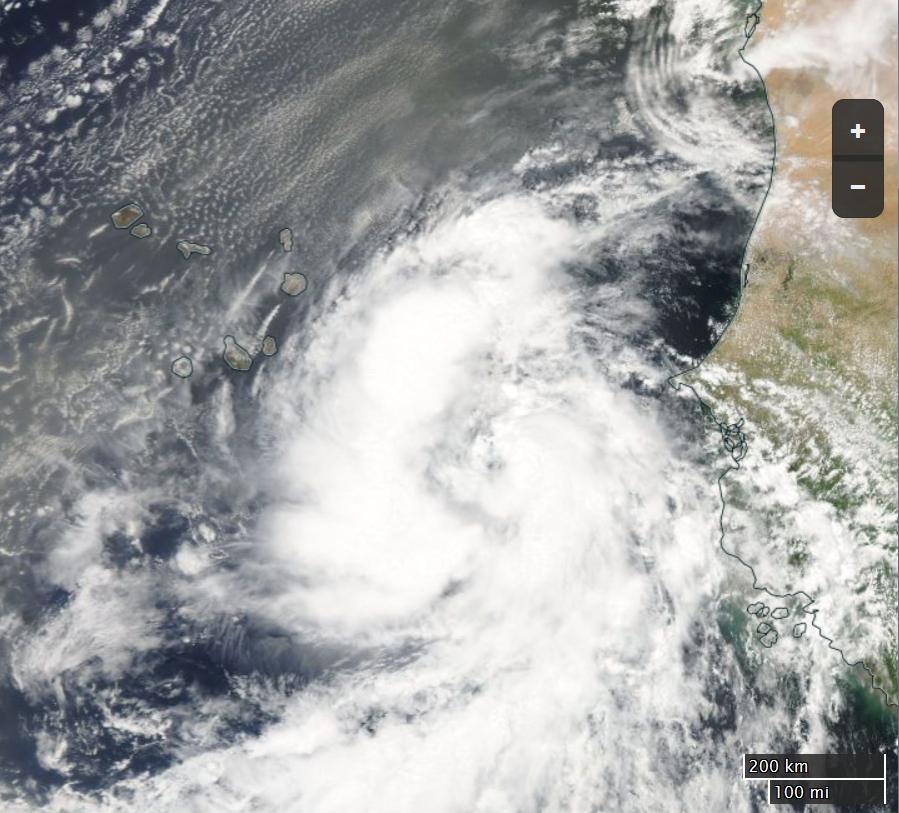
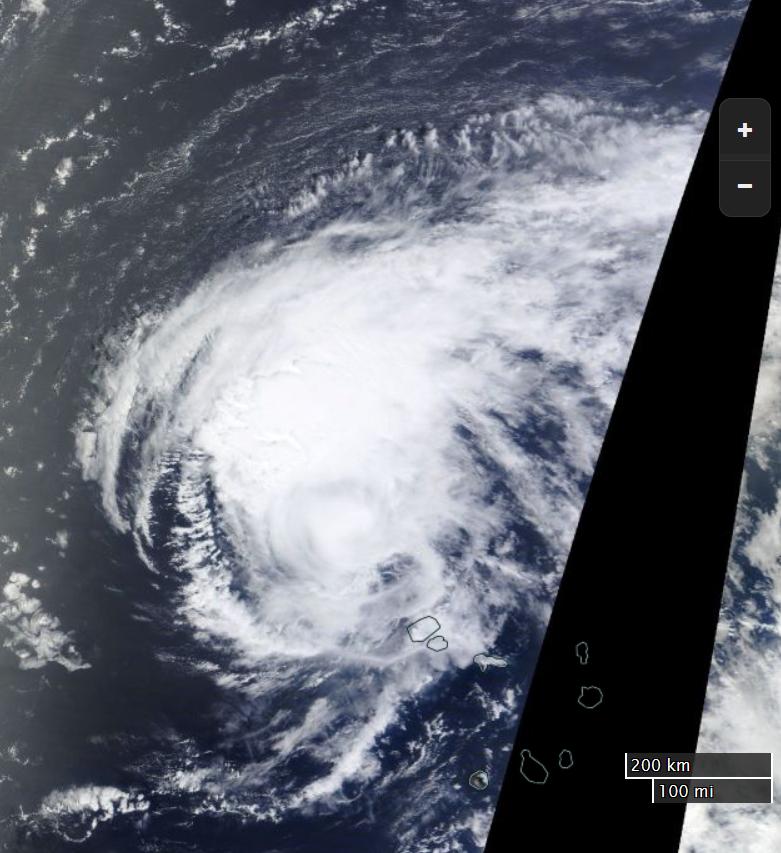
and here's how Fred looked from space yesterday:

[Edit – 14:45 UTC 31/08/2015]

The view of Fred from the Terra satellite today:

Here's a video of the effect Fred is having on Sal Island, which is the most northeasterly in the image above:

[Edit 01/09/2015]

Thanks to mosomoso for pointing out that in 1900 a hurricane formed east of the one in 1892, but still west of Fred:

The view of Fred from the International Space Station yesterday, courtesy of Scott Kelly:

The view of Fred from the Terra satellite today:

Filed under Climate by
July 26, 2015

Wet and Windy Weather is Bad For Our Beaches

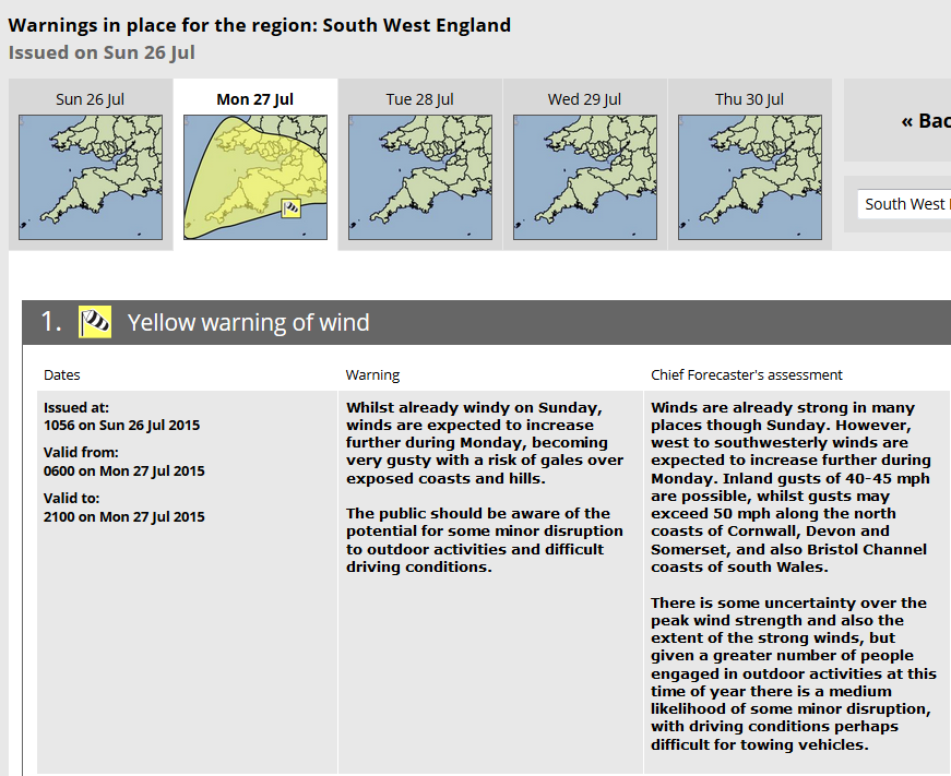
The Met Office currently has a yellow weather warning for wind in place for South West England for tomorrow:

saying that:

Winds are already strong in many places though Sunday. However, west to southwesterly winds are expected to increase further during Monday. Inland gusts of 40-45 mph are possible, whilst gusts may exceed 50 mph along the north coasts of Cornwall, Devon and Somerset

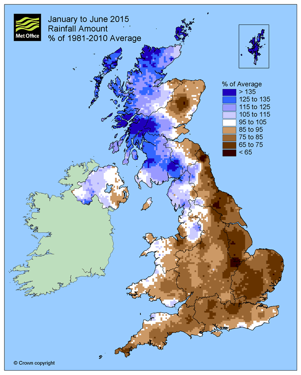
Not only that but they've also just published a blog post which shows that the summer of 2015 thus far hasn't been too bad for rain in this neck of the woods:

However the article also points out that:

Over January to June 2015 the pressure has been lower than normal to the north of Scotland but higher than normal to the south-west, resulting in a predominant westerly airflow over the UK, meaning that our weather has often been windy. Although during 2015 there have been some periods of high pressure, for example during March and early April, they have been relatively infrequent, particularly from May onwards.

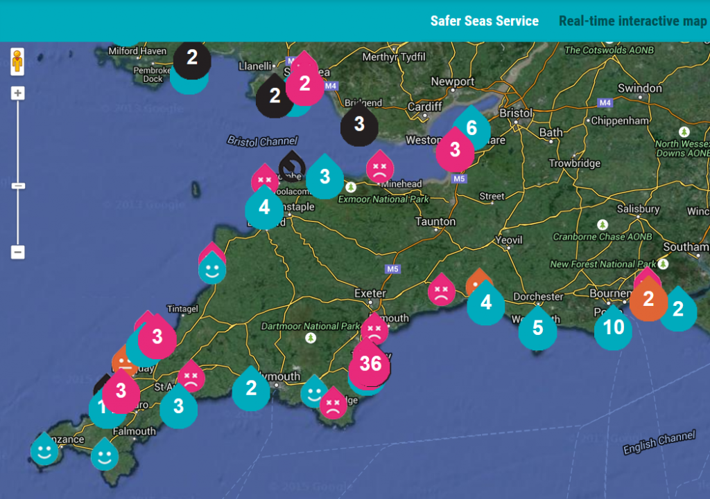
Despite the recent increasingly inclement conditions our Environment Agency flood widget currently shows no warnings. However please also take a look at the Surfers Against Sewage interactive map for South West England:

There are currently "short term pollution incidents" reported for lots of beaches across the South West peninsula, including some of our regular haunts including Woolacombe and Bude Summerleaze. Be careful out there just at the moment!

Filed under Climate by
May 10, 2015

Super Typhoon Noul Pounds the Philippines

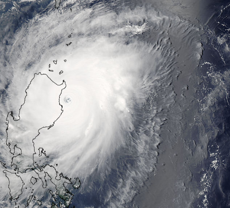
As Tropical Storm Ana makes landfall on the coast of the Carolinas as the first named tropical cyclone of the 2015 season in the Atlantic, in the western Pacific the 2015 typhoon season started back in January. Following three tropical cyclones and two full blown typhoons so far already in 2015 here's how things look over there at the moment:

NASA “true-color” image of Super Typhoon Noul on May 10th 2015, derived from bands 1, 4 and 3 of the MODIS sensor on the Aqua satellite

NASA “true-color” image of Super Typhoon Noul on May 10th 2015, derived from bands 1, 4 and 3 of the MODIS sensor on the Aqua satellite

As you can see super typhoon Noul is about to make landfall, in this case in Cayagan Province in the northeast of Luzon, the largest and most populous island in the Philippines. Here's what the latest bulletin about Noul from the Joint Typhoon Warning Center has to say:

WARNING POSITION:
100600Z — NEAR 17.9N 122.6E
MOVEMENT PAST SIX HOURS – 325 DEGREES AT 11 KTS
POSITION ACCURATE TO WITHIN 015 NM
POSITION BASED ON EYE FIXED BY SATELLITE
MAX SUSTAINED WINDS – 140 KT, GUSTS 170 KT
MAXIMUM SIGNIFICANT WAVE HEIGHT AT 100600Z IS 47 FEET.

As you can also now appreciate, Noul is a much stronger storm than Ana. Here's what the Philippines' National Disaster Risk Reduction and Management Council report in their 11:00 bulletin on May 10th, using their own name for the storm:

Typhoon Dogong has accelerated as it moves closer to Sta. Ana Point, Cayagan.
Maximum sustained winds of 185 kph near the centre and gustiness of up to 220 kph.
Forecast to move Northwest at 20 kph.
Wave Height (Open Sea) more than 14.0 meters.

For Northeastern Cagayan the projected effects of Noul include:

  • Very heavy damage to high risk structures
  • Heavy damage to medium risk structures
  • Moderate damage to low risk structures
  • Many houses of medium-built  materials are unroofed, some with collapsed walls; extensive damage to doors and windows
  • There is almost total damage to banana plantation
  • Most mango trees, ipil-ipil and similar types of large trees are downed or broken
  • Coconut plantation may suffer extensive damage
  • Rice and corn plantation may suffer severe losses

As we wait to discover the full extent of the damage to life, limb and property wrought by Noul, already waiting in the wings is "Dolphin".

Filed under Disasters by

May 9, 2015

Early Start to 2015 Atlantic Hurricane Season

The Atlantic hurricane season officially runs from June 1st until November 30th. Last year the first named storm of the season was called Arthur and he formed on July 1st. This year the first storm of the 2015 season is called Ana, and the United States National Hurricane Center first mentioned the as yet unnamed storm on May 3rd 2015:

A non-tropical area of low pressure is expected to form north of the Bahamas later this week. This system could gradually acquire some subtropical characteristics by Thursday or Friday as it moves slowly northward.

* Formation chance through 48 hours…low…near 0 percent
* Formation chance through 5 days…low…30 percent

Despite those low probabilities the NHC issued their first public advisory message for Ana late on May 7th:

SUBTROPICAL STORM ANA FORMS OFF THE SOUTHEAST U.S. COAST…

SUMMARY OF 1100 PM EDT…0300 UTC…INFORMATION
———————————————–
LOCATION…31.5N 77.6W
ABOUT 170 MI…275 KM SSE OF MYRTLE BEACH SOUTH CAROLINA
MAXIMUM SUSTAINED WINDS…45 MPH…75 KM/H
PRESENT MOVEMENT…N OR 350 DEGREES AT 2 MPH…4 KM/H
MINIMUM CENTRAL PRESSURE…1004 MB…29.65 INCHES

A TROPICAL STORM WATCH HAS BEEN ISSUED FROM EDISTO BEACH SOUTH CAROLINA TO CAPE LOOKOUT NORTH CAROLINA.

Ana formed unusually early, and is in fact the earliest named Atlantic tropical cyclone since another Ana in 2003. By this morning she had acquired the characteristics of a fully fledged tropical storm. According to the NHC once again:

ANA TRANSITIONS TO A TROPICAL STORM WHILE IT MOVES SLOWLY NORTH-NORTHWESTWARD TOWARD THE CAROLINAS…

SUMMARY OF 500 AM EDT…0900 UTC…INFORMATION
———————————————-
LOCATION…32.4N 77.6W
ABOUT 105 MI…170 KM SSE OF CAPE FEAR NORTH CAROLINA
ABOUT 115 MI…190 KM SE OF MYRTLE BEACH SOUTH CAROLINA
MAXIMUM SUSTAINED WINDS…60 MPH…95 KM/H
PRESENT MOVEMENT…NNW OR 340 DEGREES AT 3 MPH…6 KM/H
MINIMUM CENTRAL PRESSURE…998 MB…29.47 INCHES

A Tropical Storm Warning is in effect for: South Santee River South Carolina to Cape Lookout
A Tropical Storm Watch is in effect for: Edisto Beach South Carolina to South of South Santee River

HAZARDS AFFECTING LAND
———————-
WIND: Tropical storm conditions are expected within the warning area, and possible within the watch area, by this afternoon or evening.

STORM SURGE: The combination of storm surge and the tide will cause normally dry areas near the coast to be flooded by rising waters. The water could reach 1 to 2 ft above ground at times of high tide in coastal areas from Cape Hatteras, North Carolina southward through South Carolina. For information specific to your area, please see products issued by your local National Weather Service forecast office.

RAINFALL: Tropical Storm Ana is expected to produce rainfall accumulations of 1 to 3 inches, with isolated amounts of 5 inches, over eastern portions of North Carolina and South Carolina through Monday.

SURF: Swells generated by Ana are affecting portions of the southeastern U.S. coast. These swells will likely cause life-threatening surf and rip currents. Please see statements issued by your local National Weather Service forecast office.

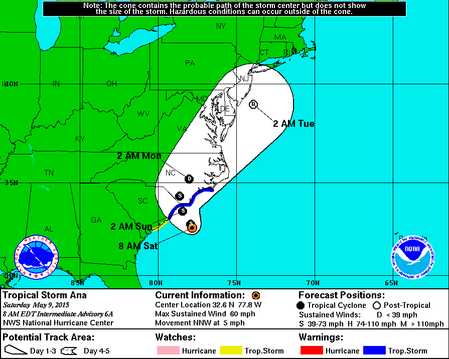
Here is Ana's current forecast track:

The NHC forecast track of Tropical Storm Ana issued at 08:00 EDT on Saturday May 9th, 2015

The NHC forecast track of Tropical Storm Ana issued at 08:00 EDT on Saturday May 9th, 2015

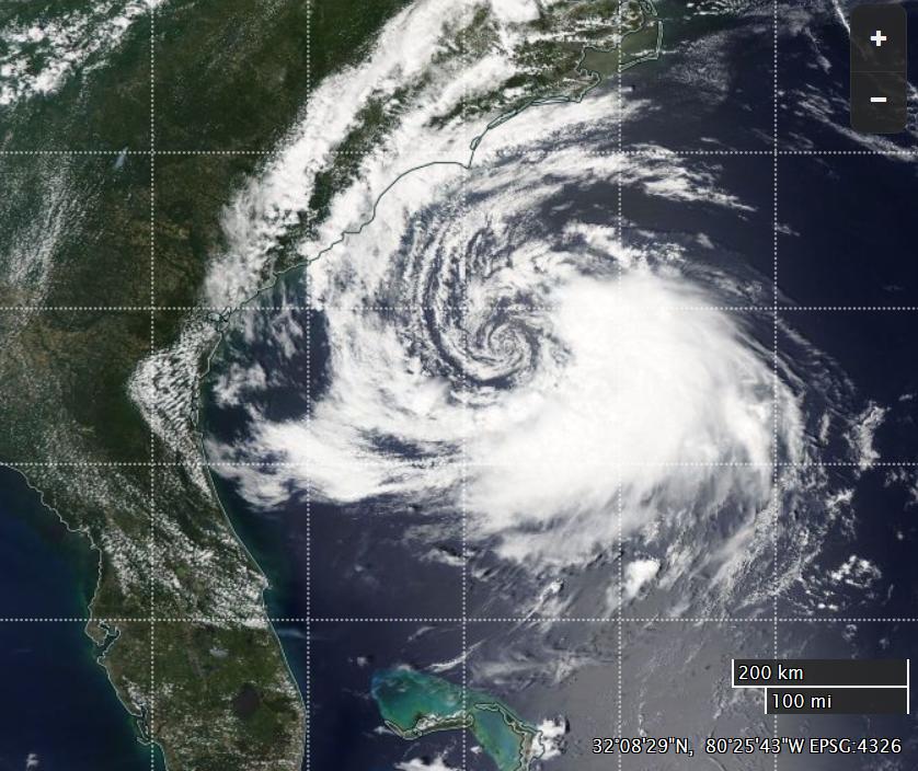
And here's what she looked like yesterday from on high, in a "true color" image derived from the MODIS instrument on the Aqua satellite:

NASA Worldview “true-color” image of Tropical Storm Ana on May 8th, derived from bands 1, 4 and 3 of the MODIS sensor on the Aqua satellite

NASA Worldview “true-color” image of Tropical Storm Ana on May 8th, derived from bands 1, 4 and 3 of the MODIS sensor on the Aqua satellite

If the forecasts are accurate Ana isn't going to turn into a hurricane, but nonetheless she is certainly going to cause a few problems for the inhabitants of the coast of the Carolinas.

Filed under Climate by