January 19, 2016
Two Pairs of Hurricane Force Storms
The Ocean Prediction Center of the United States' National Weather Service highlighted this unusual situation on their Twitter feed yesterday:
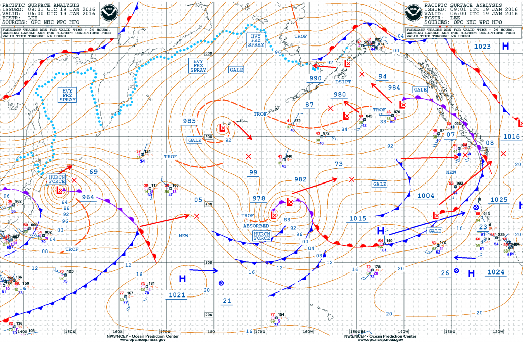
Four hurricane force lows in the two ocean basins within the next 24 hours!
Let's see how that prediction has worked out. Here's the OPC's current synopsis for the North Pacific:
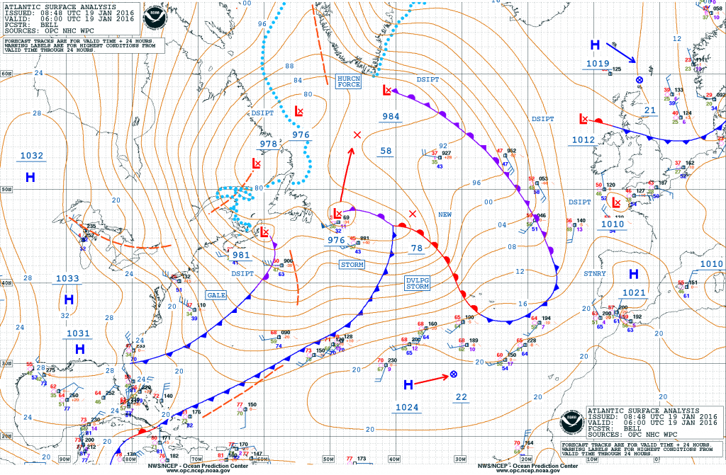
and here's the equivalent for the North Atlantic:
There's obviously two hurricane force systems in the Pacific, but the OPC "high seas" bulletin for the Atlantic has this to say this morning:
HURRICANE FORCE WIND WARNING…
LOW 56N52W 982 MB MOVING NW 10 KT. FRONT EXTENDS FROM LOW CENTER TO 57N42W TO 56N35W.
FROM 58N TO 60N BETWEEN 42W AND 49W. WINDS 50 TO 65 KT. SEAS 21 TO 28 FT.
ELSEWHERE FROM 58N TO 60N BETWEEN 37W AND 52W WINDS 40 TO 50 KT. SEAS 19 TO 24 FT.
ALSO WITHIN 240 NM NW AND N OF THE FRONT WINDS 25 TO 40 KT. SEAS 12 TO 20 FT.24 HOUR FORECAST LOW DISSIPATED. N OF A FRONT TO EXTEND FROM 60N44W TO 59N35W WINDS 25 TO 35 KT. SEAS 11 TO 18 FT.
48 HOUR FORECAST CONDITIONS DIMINISHED.
and also this:
HURRICANE FORCE WIND WARNING…
24 HOUR FORECAST NEW LOW 41N45W 990 MB. FRONT TO EXTEND FROM LOW CENTER TO 37N59W TO 36N67W. WITHIN 120 NM SE OF THE FRONT. WINDS 40 TO 50 KT. SEAS 18 TO 28 FT.
ELSEWHERE OVER FORECAST WATERS WITHIN 600 NM SE…1500 NM SW…AND 660 NM NW QUADRANTS. WINDS 25 TO 40 KT. SEAS 12 TO 24 FT.48 HOUR FORECAST LOW 57N36W 956 MB. BETWEEN 60 NM AND 120 NM N AND S QUADRANTS WINDS 50 TO 65 KT. SEAS 17 TO 26 FT.
ELSEWHERE WITHIN 180 NM N AND S QUADRANTS WINDS 40 TO 50 KT. SEAS 16 TO 20 FT. ALSO WITHIN 300 NM OF CENTER…EXCEPT 180 NM SW QUADRANT WINDS 25 TO 40 KT. SEAS 15 TO 18 FT.
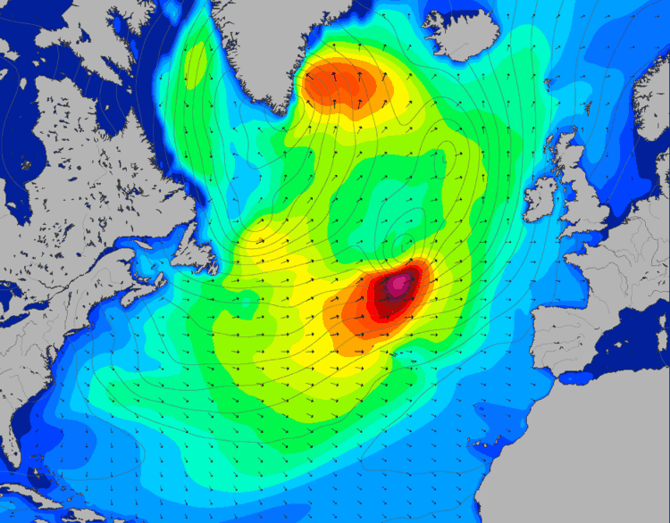
Two separate hurricane force systems then, but whether they'll be simultaneously producing winds of that strength remains to be seen. Nonetheless, here is Magic Seaweed's surf forecast for the North Atlantic on Thursday afternoon:
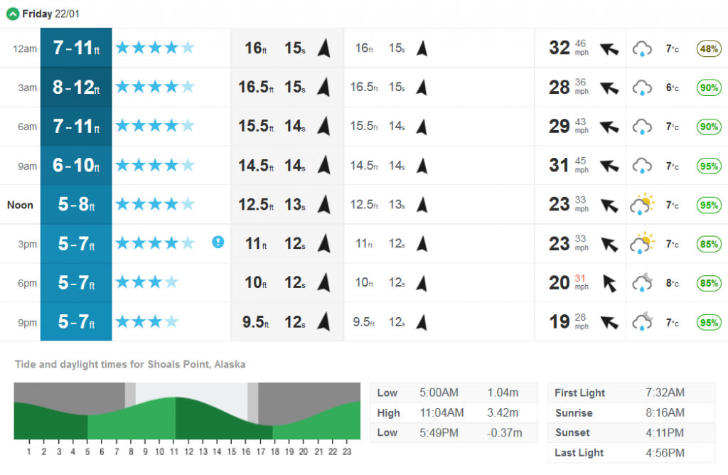
One large swell heading for Southern Greenland, and another one heading straight for Soggy South West England! Meanwhile over in the Pacific surfers in Alaska have this to look forward too later in the week:
As far as I can ascertain Magic Seaweed don't produce a surf forecast for Greenland!
Filed under Climate by


Comments on Two Pairs of Hurricane Force Storms »
Heading on to land just for a change, the NWS home page currently reads as follows:
The NWS's Weather Prediction Center chart for the United States on Friday looks like this:
Note that it shows both solid and liquid precipitation on both east and west coasts.
Back out at sea, here's the OPC's 12:00 UTC chart for today:
The low just north of Newfoundland is down to 953 hPa central pressure, and not too far away there are "developing hurricane force" winds once again. Here's the OPC's current forecast:
In their forecast this morning the NWS Ocean Prediction Center have two warnings for hurricane force winds in the North Atlantic once again:
Here's their Atlantic forecast for two days time:
which amongst many other things suggests that the Davis Strait to the west of Greenland will soon be experiencing much colder temperatures than of late. Here's the resulting Magic Seaweed North Atlantic surf forecast for today:
Let's not forget those storms still spinning in the North Pacific either. Here is today's MSW surf forecast for Alaska:
Finally, for the moment at least, here is the current NWS weather forecast for the United States' eastern seaboard:
Their Washingtom DC branch has issued a blizzard watch:
Here's the latest synoptic chart from the Ocean Prediction Center for the North-East Pacific:
Hurricane force winds around a 956 hPa central pressure low, about which the OPC have this to say: