HURRICANE MATTHEW TROPICAL CYCLONE UPDATE
NWS NATIONAL HURRICANE CENTER MIAMI FL AL142016
SUMMARY OF 1200 PM EDT…1600 UTC…INFORMATION
———————————————–
LOCATION…25.3N 78.0W
ABOUT 45 MI…70 KM WNW OF NASSAU BAHAMAS
ABOUT 160 MI…260 KM SE OF WEST PALM BEACH
MAXIMUM SUSTAINED WINDS…140 MPH…220 KM/H
PRESENT MOVEMENT…NW OR 325 DEGREES AT 14 MPH…22 KM/H
MINIMUM CENTRAL PRESSURE…940 MB…27.76 INCHES
The asterisk on the legend is explained by the NHC as follows:
*Displayed flooding values indicate the water height that has about a 1-in-10 (10%) chance of being exceeded.
Some of the red "Greater than 9 feet above ground" areas on the storm surge map are a long way inland. Maybe that explains why there are already mandatory evacuation orders in place for the Florida coast?
No doubt there will be a huge increase in power outages as Matthew gets ever closer, but currently Florida Power reports around 13,000 customers without electricity, with another 13,000 whose power has already been restored.
It's a long time since the 2016 Atlantic hurricane season started way back in January as Hurricane Alex headed for Greenland.
Today we bring you news of Hurricane Matthew, who swept through the Lesser Antilles into the Caribbean Sea as a mere tropical storm but has now turned north and strengthened into a major hurricane. Matthew briefly reached category 5 status yesterday with sustained wind speeds of 160 miles per hour, but those winds have dropped down to a mere 150 mph this morning. Like Alex, Matthew has several claims to fame, most notably as the southernmost category 5 hurricane ever recorded in the Atlantic, at 13.3° north. Here's the current forecast from the National Hurricane Center:
As you can see, there are hurricane warnings already in place for Jamaica, Cuba, and Haiti. There is always some uncertainty over the forecast track of any hurricane. In this case that can be gauged by looking at the current NOAA Geophysical Fluid Dynamics Laboratory ensemble forecast for Matthew:
At the moment it seems highly likely that Matthew's eye will pass over western Haiti before passing close to or over Eastern Cuba and then heading in the general direction of the east coast of the United States. It's far too early to say with certainty whether Matthew will make landfall on the mainland of the United States of America, but here is the Global Forecast System's best guess for 138 hours from 6 AM this morning:
Storm Katie is forecast to affect southern England and south Wales on Easter Monday
Anticipating the development of an area of low pressure, which will affect southern England and south Wales on Easter Monday, The Met Office has decided to name the storm Katie. This will be the 11th named storm since last autumn.
It's currently only Easter Saturday, but we've already had some fairly strong winds in South West England. Here's the Met Office's warning map for today:
The associated warning reads as follows:
A swathe of strong winds, accompanied by a band of heavy rain will move east across England and Wales during Saturday afternoon and early evening. This is expected to bring gusts of 40-50 mph to inland areas, perhaps 60 mph across exposed coasts and hills, as well as on the passage of the cold front, when heavy rain could also produce some very localised surface water flooding.
Please be aware of the possibility of localised low levels of disruption to Easter travel plans and other holiday activities.
Despite that final sentence there are currently no flood alerts or warnings in place for South West England. Moving on to Easter Monday, the wind warning for Storm Katie only covers Southern England:
Issued at: 1031 on Sat 26 Mar 2016
Valid from: 0115 on Mon 28 Mar 2016
Valid to: 1400 on Mon 28 Mar 2016
Winds will strengthen markedly across southern England and through the Bristol Channel from the start of Monday, with the potential for 50-60 mph gusts inland and 70 mph gusts around coasts exposed to the south. Whilst there is a low likelihood of all areas seeing these strong gusts for a time southern coastal counties from Hampshire eastwards look most likely to see the strongest winds. These will then ease from the southwest during the morning, clearing from the east early in the afternoon. Additional hazards may include large waves around exposed coasts as well as a period of heavy rain.
Please be aware of the potential for disruption to outdoor activities and travel, as well as the possibility of fallen trees and temporary interruptions to power supplies.
From the current forecast I can't see that there will be as many "temporary interruptions to power supplies" as "The storm with no name" produced earlier this month. However the Met Office's "Chief Forecaster's assessment" does say that:
There remains a fair amount of uncertainty over the track and timing of this system and so where and when the peaks of strongest winds will occur. However, there is a continuing signal for a period of disruptive winds, perhaps now more focussed towards southeastern parts of England. This alert will be updated on Sunday in light of further information.
More news from us on the forecast for Storm Katie tomorrow.
This morning the Met Office issued yet another severe weather warning for South West England. Here's their map for tomorrow:
The worst of the rain will be north-east of here, but regarding the winds the Met Office have this to say:
Widespread gales, and severe gales in more exposed areas, are expected to develop during the early hours of Wednesday bringing gusts of 50-60 mph to some inland areas and gusts to 70 mph to some coastal areas and higher ground. The winds will slowly ease during the afternoon. Combined with heavy rain these high winds are likely to produce some difficult driving conditions.
Please be aware of the risk of disruption to transport and possible disruption to power supplies, as well as high waves overtopping some coastal routes.
The "Chief Forecaster's assessment" adds that:
In spite of the exact track and intensity of this depression remaining subject to a little uncertainty, a period of very windy weather is on the cards for Wednesday early hours and morning.
Here's the Global Forecast System's prediction for wind gusts tomorrow morning, courtesy of MeteoCiel:
Thus far the Met Office haven't decided that the forecast winds are sufficiently strong to give this latest storm the official name of "Storm Katie". However given the forecast severe weather I cycled up to the top of Haldon Hill this afternoon to talk to the rangers at the Haldon Forest Park. Sure enough they told me that the park will be closed tomorrow. Things should be back to normal up there by Thursday, assuming that there aren't too many fallen trees to clear from the paths and bike trails.
Tropical Cyclone Winston has already headed east across the South Pacific past Fiji. Now he has suddenly reversed direction and is heading directly for Fiji where he is expected to arrive as a category 5 storm. Here is the current Joint Typhoon Warning Center forecast track for Winston:
The southern hemisphere tropical cyclone season normally runs from November to April and so far this season activity in the South Pacific Ocean has been relatively low. Just two tropical cyclones have formed which have reached the equivalent of hurricane strength – Ula and Victor.
Almost 10 days ago Tropical Storm Winston formed just to the east of Vanuatu in the South Pacific. The storm initially moved southwards passing to the west of Fiji with winds strengthening to more than 100 mph. Winston then started to weaken, but instead of continuing on a track towards higher latitudes, made an unusual turn north-eastwards. Despite weakening to a tropical storm as it did so Winston brought heavy rain to parts of Tonga earlier this week. Having stalled just south of Samoa, Winston then started to restrengthen and made another sharp turn towards the west.
The latest forecast track takes the centre of the cyclone initially across the smaller eastern islands of Fiji and eventually over its largest island of Viti Levu which includes the capital Suva. Winston is likely to maintain its current intensity and bring up to 400mm rain. The combination of strong winds, heavy rain and storm surge are likely to produce damage and destruction to the islands this weekend.
WARNING POSITION:
191200Z — NEAR 17.3S 177.5W
MOVEMENT PAST SIX HOURS – 275 DEGREES AT 15 KTS
POSITION ACCURATE TO WITHIN 020 NM
POSITION BASED ON EYE FIXED BY SATELLITE
MAX SUSTAINED WINDS – 125 KT, GUSTS 150 KT
TROPICAL CYCLONE (TC) 11P (WINSTON), LOCATED APPROXIMATELY 239 NM EAST OF SUVA, FIJI, HAS TRACKED WESTWARD AT 15 KNOTS OVER THE PAST SIX HOURS.
THE INITIAL INTENSITY IS ASSESSED AT 125 KNOTS BASED UPON DVORAK CURRENT INTENSITY ESTIMATES OF T6.5 (127 KNOTS) FROM MULTIPLE AGENCIES. UPPER LEVEL ANALYSIS INDICATES A FAVORABLE ENVIRONMENT WITH DUAL CHANNEL OUTFLOW AND WEAK (5 TO 10 KNOTS) VERTICAL WIND SHEAR (VWS).
THE SYSTEM IS CURRENTLY FORECAST TO MAKE LANDFALL ALONG THE EAST COAST OF FIJI AROUND TAU 24, WITH AN INTENSITY BETWEEN 125 AND 130 KNOTS. AFTER TAU 24, THE SYSTEM WILL BEGIN TO WEAKEN DUE TO LAND INTERACTIONS.
It's February 14th today, better known as Saint Valentine's Day. Much like last year the Great British nation is currently being exhorted to #ShowTheLove for the environment. Here what David Cameron pledged exactly one year ago today:
To seek a fair, strong, legally binding, global climate deal which limits temperature rises to below 2°C.
To work together, across party lines, to agree [UK] carbon budgets”, which are required by law but which caused serious cabinet clashes in 2011.
To accelerate the transition to a competitive, energy-efficient low-carbon economy and to end the use of unabated coal for power generation.
Has any of that happened? If so I must have blinked and missed it!
You will note that at approx. 1 minute 25 seconds Jeremy Irons says that:
One day Mia, if we don't care for it, this good Earth of ours will be as arid and lifeless as the moon. Have you ever seen a picture of Earth from Space?
Heavy rain affected the northern part of the Caribbean island of Hispaniola between 09 and 11 February 2016, resulting in flooding in parts of both Dominican Republic and Haiti.
After a long period of intense drought, Puerto Plata Province on the northern coast of Dominican Republic saw 216 mm of rain in 24 hours in Puerto Plata station, between 10 and 11 February 2016.
According to local media, the San Marcos River and the Camú River overflowed, causing flooding in the municipalities of Puerto Plata, Montellano and Villa Isabela. Several houses are reported to be affected by local inundations in La Sabana, Las Cruces de Martín Alonso, Tasajera, Estrecho Abajo, El Estrecho, Ranchito de los Vargas communities.
The northern coast of Haiti has also been affected by heavy and prolonged rainfall which occurred between 9 to 11 February 2016.
Major cities including Port-de-Paix and Cap-Haïtien have been affected by the severe weather and more than 200 houses have been damaged, forcing families to leave their home. Several neighbourhoods of Cap-Haïtien, including Carénage, Cité Lescot, Sainte Philomène and Charrier, suffered flooding on the 11 February.
Flooding blocked roads and caused traffic problems. The heavy rain also caused a mudslide which blocked the main road in the district of Bel-Air, according to local media.
With wide areas of standing water, contaminated flood water and streets littered with waste and garbage, focus has turned to health concerns. Haiti public health authorities have called for people to be aware of the threat of the spread of cholera and other water-borne diseases, and to take necessary preventative measures in flood-affected areas of Cap-Haïtien and Port-de-Paix.
In other recent news, this time about the drought in Haiti, the United Nations World Food Program said on February 9th that:
Haiti's third consecutive year of drought, exacerbated by the global El Niño weather phenomenon, has driven people deeper into poverty and hunger, and doubled the severely food-insecure population, the United Nations World Food Programme (WFP) said today.
Some 3.6 million Haitians are facing food insecurity, among them more than 1.5 million people who are severely food insecure. This is a key finding from an emergency food security assessment conducted by WFP, the UN Food and Agriculture Organization (FAO) and National Food Security Coordination.
The main harvest in 2015 fell below average, with losses of up to 70 per cent in some areas. This is severely threatening food security in Haiti, where agriculture employs half of the working population and 75 per cent of people live on less than $2 per day.
In addition, the current El Niño phenomenon, which began in early 2015, is one of the strongest on record and is affecting the food security of vulnerable people around the globe, including in Haiti.
In some areas of the country, up to 70 per cent of the population is facing hunger and a recent study conducted by the UN Children's Fund (UNICEF) and the Government of Haiti revealed that malnutrition rates are above emergency levels in several communes.
Wendy Bigham, WFP's Deputy Country Director in Haiti, said in a news release that:
Without rain for the 2016 spring season, farmers will lose their fourth consecutive harvest on which they normally depend to feed their families. We need to help them meet their immediate needs and help build up their resilience.
Storm Imogen arrived overnight, announcing her appearance with thunder and lightning here in the Haldon Hills. Now that the sun has risen, here's how the surf on the north coast looks at Woolacombe, courtesy of Trev Lumley of Eyeball Surfcheck:
The Eyeball live surfcam isn't completely lathered in spray like most of the others, and you can see it shaking in the gusting winds. Here's a snapshot:
Trev's eminently sound advice is:
Completely and utterly BLOWN-OUT folks, with gale to severe gale onshore Westerly winds.
Don't even think about it dudes as in I hope it goes without saying that such conditions are rare and extreme caution needs to be taken before even thinking about entering even the most extreme sheltered breaks.
Meanwhile further out into the North Atlantic Ocean some buoys are bobbing about in the incoming swell, as is the Sevenstones lightship. Here's what she's reporting at the moment, courtesy of Magic Seaweed:
Moving on to those winds, here is the latest weather report from RAF Culdrose, just down the North Devon coast from Woolacombe, courtesy of Weather Underground:
Finally, for the moment at least, there are currently 27 flood warnings and 74 flood alerts across Soggy South-West England.
It's now just after 19:00 hours on Sunday February 7th 2016, and I suppose it's time to start battening down our hatches? Here's how our handy South-West England flood widget looks at present:
Here's the Magic Seaweed surf forecast for the British Isles for midnight tonight:
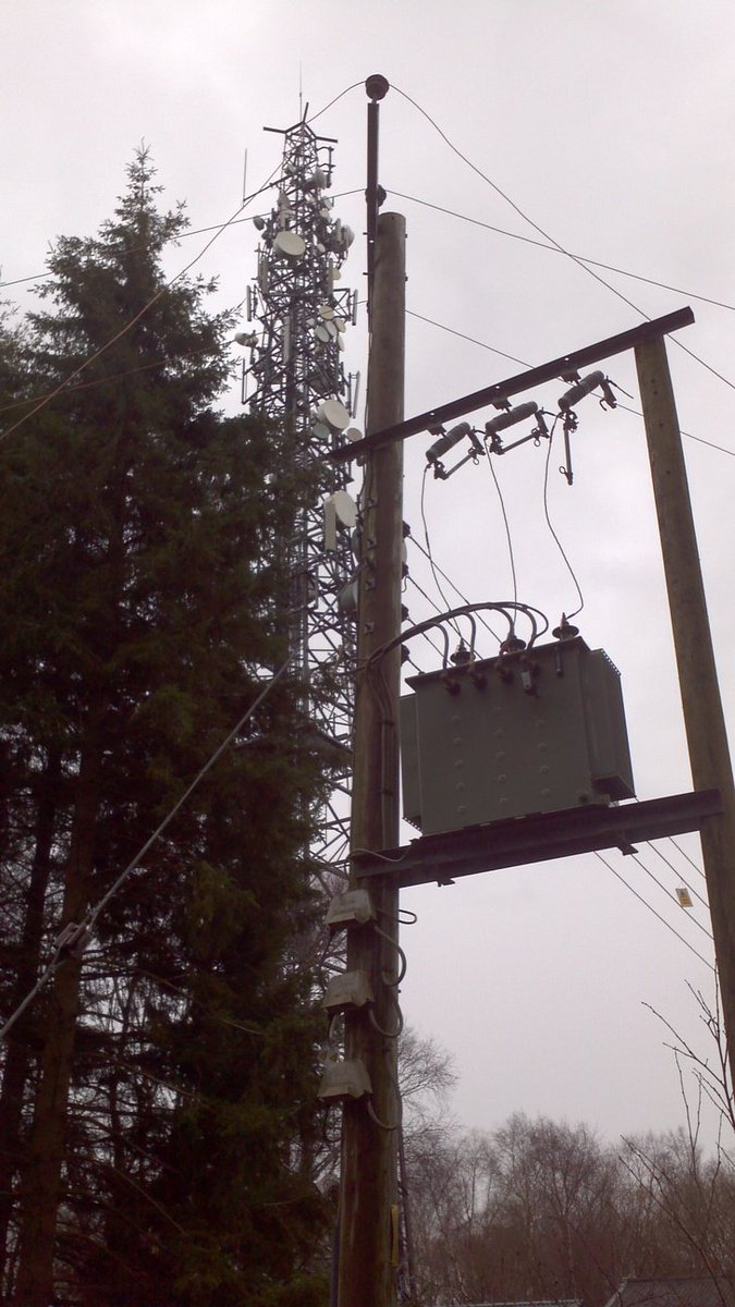
Just in case you're wondering the scale is in km/h, not mph! Nonetheless I have a torch and a large supply of candles and matches handy, in part because on my pre Imogen bike ride around the infrastructure of the Haldon Hills this afternoon I couldn't help but notice this:
If you suffered a mobile telecommunications breakdown anywhere near Telegraph Hill earlier today that's probably because a tree fell across the wires carrying electricity to the telecoms mast on the Haldon ridge.
The Environment Agency have just issued their first red "severe flood warning" of the day, for Portreath in Cornwall:
The Portreath tunnel trash screen is now overtopping and flood waters are impacting Portreath. Conditions at Portreath are deteriorating quickly and the situation is expected to deteriorate with further rainfall expected. Road access to Portreath through Bridge is likely to be dangerous so drivers should avoid driving through this location.
12:00 on 06 Feb 2016
Here's how the River Dart near Dartington looked an hour or so ago:
River levels are continuing to rise following the heavy rain experienced this morning. Further rainfall is expected throughout Saturday with widespread rainfall totals of 30mm – 40mm anticipated in the area. River levels will continue to rise throughout Saturday morning, increasing throughout the day and into the early evening. River levels are likely to fall during Sunday with lower rainfall totals forecast. Flooding is likely to affect properties close the river. We will continue to monitor the situation and update this message if the situation changes
10:42 on 06 Feb 2016
Please do bear in mind that according to the Environment Agency:
Flood Warning – Flooding is expected. Immediate action required Severe Flood Warning – Severe flooding. Danger to life.
[Edit – 12:45]
Here's a picture of the "flooding down the main road through Portreath, Cornwall":
I was in a series of meetings halfway up a London skyscraper listening to the remnants of Blizzard/Winter Storm Jonas last week, so my news of Storm Gertrude is slightly belated. Before Gertie arrived one of our number had to jump on a train back to the North of England to deal with a personal flooding problem thanks to the amount of precipitation that ex Jonas deposited on the already sodden soil up there. He wasn't the only one affected:
Hot on the heels of Jonas, Storm Gertrude arrived from across the North Atlantic, with the United Kingdom's Met Office helpfully providing some moving pictures to explain that:
Very cold air is spilling southwards out of Arctic Canada and meeting much milder air across parts of the Western Atlantic forming a very strong temperature gradient, and that forces a very strong jet stream which spins these systems up.
Storm Gertrude is sweeping across parts of the UK with winds of more than 100mph causing damage to buildings, travel disruption and power cuts.
In Edinburgh, a man was hospitalised after being struck by flying debris, and a rare Met Office "danger to life" wind warning is in place for Shetland.
At least 4,000 homes are without power in Scotland and Northern Ireland. Trains, flights and ferries have been cancelled and roads and bridges shut.
There are flood warnings across the UK.
Gertrude then continued on towards Scandinavia, where she morphed into "Storm Tor". As "Norway Today" reported yesterday:
The hurricane tore loose ships and roofs
A huge supply vessel under construction was torn loose in the hurricane that ravaged in Sunnmøre Friday night. In Ålesund the hurricane was the cause of flying objects, which made it dangerous to go outside.
It must be one of the largest ships under construction in the country, but because there are no people on board, we will not get involved, the JRCC for southern Norway states to NTB.
The ship is well over 190 meters and has been torn loose and lies across the bay.
Now comes news that the Met Office have officially given the name "Henry" to the next deep low pressure system racing our way, which is due to arrive overnight. Here is their surface level pressure forecast for lunchtime tomorrow:
The German climate scientist Stefan Rahmstorf outlined his theory about the reason for the current conveyor belt of strong storms over at "Real Climate":
I will argue that this warmth (as well as the cold blob in the subpolar Atlantic) is partly due to a slowdown of the Atlantic Meridional Overturning Circulation (AMOC), sometimes referred to as the Gulf Stream System, in response to global warming. There are two points to this argument:
(1) The warm sea surface temperatures are not just some short-term anomaly but are part of a long-term observed warming trend, in which ocean temperatures off the US east coast are warming faster than global average temperatures.
(2) Climate models show a “cold blob” in the subpolar Atlantic as well as enhanced warming off the US east coast as a characteristic response pattern to a slowdown of the AMOC.
A week is a long time in weather forecasting, especially in the North Atlantic just at the moment, but next on the Met Office's list of names for dangerous storms is "Imogen"!
Whilst we wait to discover what swells are sweeping across the North Atlantic next weekend, here is the Magic Seaweed surf forecast for tomorrow:


