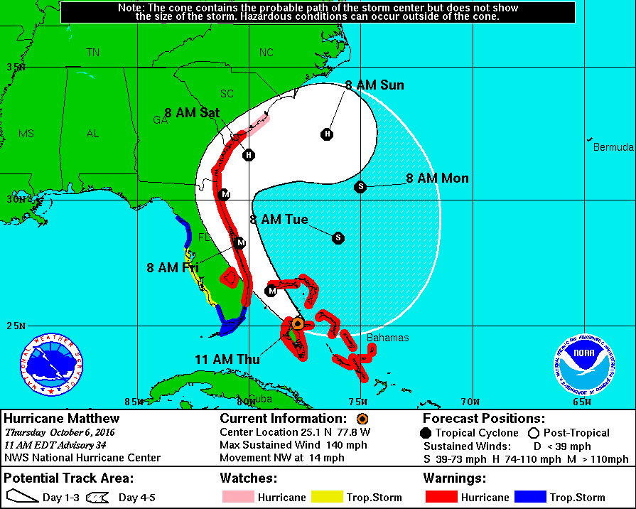
Hurricane Matthew has already caused death and devastation across the Caribbean and Bahamas, and now he's heading for Florida. Firstly here's the latest National Hurricane Center track forecast:

together with the current NOAA Geophysical Fluid Dynamics Laboratory ensemble forecast for Matthew:
More on Hurricane Matthew's Storm Surge Threatens Florida
Filed under Disasters by Jim Hunt
Way back on May 9th we reported on an unusually early start to the 2015 Atlantic Hurricane Season. Things have been fairly quiet since then. There have been a few named tropical storms, one of which became Hurricane Danny on August 20th. Danny didn't pose much threat to life and limb, but another unusual tropical storm is about to change that. At 06:00 UTC this morning the National Hurricane Centre advised that:
More on Hurricane Fred Threatens Cape Verde Islands
Filed under Climate by Jim Hunt
The Atlantic hurricane season officially runs from June 1st until November 30th. Last year the first named storm of the season was called Arthur and he formed on July 1st. This year the first storm of the 2015 season is called Ana, and the United States National Hurricane Center first mentioned the as yet unnamed storm on May 3rd 2015:
More on Early Start to 2015 Atlantic Hurricane Season
Filed under Climate by Jim Hunt
The Met Office has published a joint article with the Environment Agency about what it refers to as "super tides":
There has been a lot of media coverage about the potential impact of so-called ‘super tides’ which are due from today (Friday, 20 February) through to Monday.
More on Britain Expects a Battering From a "Super Swell"
Filed under Climate by Jim Hunt
A report from the Australian Government Bureau of Meteorology Tropical Cyclone Warning Centre in Brisbane this morning warns that:
SEVERE TROPICAL CYCLONE ITA, CATEGORY 4, poses a serious threat to communities along the far north Queensland coast. It is expected to continue to move in a general south-southwest direction and make landfall near Cape Flattery tonight with VERY DESTRUCTIVE WINDS to 275 kilometres per hour near the core and GALES extending out to 185 kilometres from the centre.
More on Severe Tropical Cyclone Ita Heads For Australia
Filed under Disasters by Jim Hunt
According to the latest advisory bulletin issued by the United States Navy's Joint Typhoon Warning Center (JTWC for short), based at Pearl Harbour in Hawaii, Tropical Storm Bopha has now developed hurricane force winds, and is therefore now classified as a typhoon:
More on Typhoon Bopha Has Her Eye on the Philippines
Filed under Disasters by Jim Hunt
Last summer we speculated about what might happen if the winds and/or storm surge from Hurricane Irene happened to hit the Brunswick nuclear plant in North Carolina head on. As luck would have it Irene weakened and veered to the north, but did she did go on to cause the shut down of the Oyster Creek nuclear reactor in New Jersey, amongst numerous other problems.
More on US Nuclear Plants Issue "Alerts" Following Sandy Storm Surge
Tags: Entergy, Exelon Corp., Indian Point, Limerick, Nine Mile Point, NRC, Nuclear, Oyster Creek, PSEG, Salem, Sandy 2012, SCRAM, Storm Surge
Filed under Disasters by Jim Hunt
Hurricane Sandy turned sharp left as (ultimately) predicted, and crossed the eastern coast of the United States last night rather earlier than anticipated earlier in the day. Advisory bulletins on "Post-tropical Cyclone Sandy" are now being issued by the HPC instead of the NHC. Their first one says that:
More on Sandy "Plunges New York City Into Darkness"
Filed under Disasters by Jim Hunt
Monday morning has dawned, and it's raining again here in not so sunny South West England. Over on the other side of the Atlantic the news about Hurricane Sandy hasn't improved overnight. Here's how the latest National Hurricane Center prediction looks at the moment:
More on Sandy Predicted to Morph Into a Post-Tropical Cyclone
Filed under Disasters by Jim Hunt
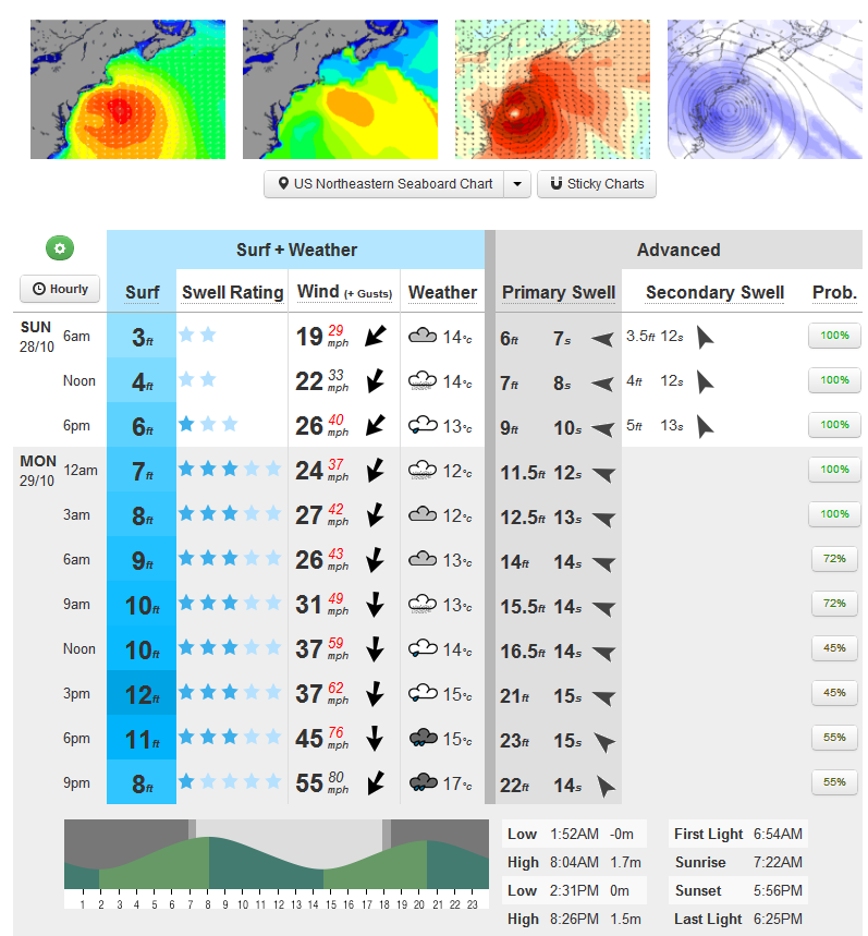
Much as we did last year as Hurricane Irene bore down on New York City, we hereby present the surf forecast for the entrance to New York Bay, courtesy of MagicSeaweed:

MagicSeaweed surf forecast for The Cove on Monday October 29th 2012
More on Storm Surge Shuts the Subway in New York
Filed under Disasters by Jim Hunt

