April 11, 2014
Severe Tropical Cyclone Ita Heads For Australia
A report from the Australian Government Bureau of Meteorology Tropical Cyclone Warning Centre in Brisbane this morning warns that:
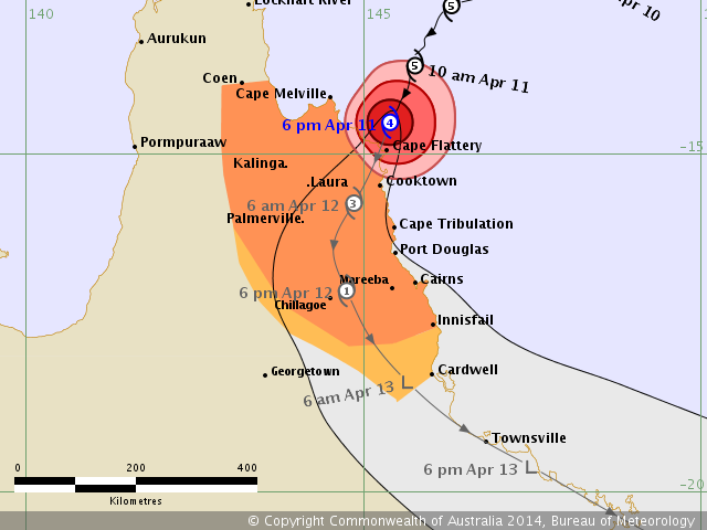
SEVERE TROPICAL CYCLONE ITA, CATEGORY 4, poses a serious threat to communities along the far north Queensland coast. It is expected to continue to move in a general south-southwest direction and make landfall near Cape Flattery tonight with VERY DESTRUCTIVE WINDS to 275 kilometres per hour near the core and GALES extending out to 185 kilometres from the centre.
DESTRUCTIVE WINDS with wind gusts in excess of 125 kilometres per hour are currently occurring at Cape Flattery and should develop elsewhere between Cape Melville and Cooktown this evening, extending south to Cape Tribulation overnight and possibly to Port Douglas during Saturday morning. GALES are occurring between Cape Melville and Cooktown and should extend south to Cape Tribulation this evening and inland to Laura and Palmerville overnight. Gales may extend south to Cairns and Innisfail and inland to Chillagoe during Saturday, and possibly to Cardwell later in the evening.
There remains the small possibility that Ita could track south close to the coast tonight and maintain an intensity capable of generating destructive wind gusts to 150 kilometres per hour in Cairns during Saturday.
Here is the current forecast track for Severe Tropical Cyclone Ita,
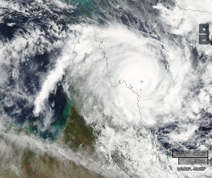
As you can see Ita has recently reduced in intensity from Category 5. Here's the view of Ita from the Aqua satellite at the moment, where you can just make out the "eye of the cyclone" just offshore when the image was recorded:
Regarding the potential storm surge and flooding, the Bureau of Meteorology had this to say:
Coastal residents between Cape Melville and Cape Tribulation, including Cooktown are specifically warned of the dangerous storm tide as the cyclone crosses the coast tonight. The sea is likely to rise steadily up to a level which will be significantly above the normal tide, with damaging waves, strong currents and flooding of low-lying areas extending some way inland. People living in areas likely to be affected by this flooding should take measures to protect their property as much as possible and be prepared to follow instructions regarding evacuation of the area if advised to do so by the authorities.
Very heavy rain, which may lead to flash flooding, is developing about parts of the Peninsula and North Tropical Coast and Tablelands districts and should gradually contract southwards with the system over the weekend.
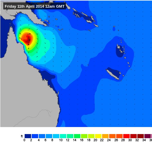
Here is the current swell forecast for Queensland, courtesy of the MagicSeaweed surf forecasting web site:
Filed under Disasters by


Comments on Severe Tropical Cyclone Ita Heads For Australia »
The latest Australian Government Bureau of Meteorology tropical cyclone advice bulletin about Ita, issued at 7:52 pm EST on Friday 11 April 2014, says that:
The latest Australian Government Bureau of Meteorology advice bulletin about severe tropical cyclone Ita, issued at 9:11 pm EST on Friday 11 April 2014, says that:
The latest Australian Government Bureau of Meteorology high seas weather warning, issued at 13:02 UTC on Friday 11 April 2014, says that there is a:
The Cairns Local Disaster Management Group have advised:
Storm tide surge evacuation maps are available from:
http://www.cairns.qld.gov.au/cyclone-emergency-information/evacuation
Up to the minute information can be viewed on the Cairns Disaster Coordination Centre Facebook page.
https://www.facebook.com/CairnsDCC