Hurricane Sandy turned sharp left as (ultimately) predicted, and crossed the eastern coast of the United States last night rather earlier than anticipated earlier in the day. Advisory bulletins on "Post-tropical Cyclone Sandy" are now being issued by the HPC instead of the NHC. Their first one says that:
More on Sandy "Plunges New York City Into Darkness"
Filed under Disasters by Jim Hunt
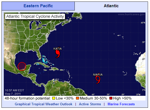
The September 7th overview of the North Atlantic from the National Hurricane Centre shows two red storms apart from Hurricane Katia:

North Atlantic tropical cyclone activity at 10:57 AM on Wednesday September 7th 2011
More on Maria Makes Her Appearance. Death Tolls Rise Elsewhere.
Filed under Disasters by Jim
Back in January the Association of Surfing Professionals announced their controversial decision to hold:
The first-ever ASP World Tour stop on the East Coast of the United States, set to take place on Long Island’s Long Beach from September 4-15. The event will offer a $1 million dollar prize purse to competitors, an amount unprecedented in professional surfing.
According to the initial press release:
More on Surfing Professionals at Long Beach Look Forward to Katia's Swell
Filed under Disasters by Jim
Yesterday I became involved in a debate over on the Economist website about "hurricane hype". The article is entitled "The Storm-clouds clear" and was based on the premise that Hurricane Irene didn't turn out to be as bad as predicted. I was definitely on the side of those expressing the view that you should:
More on Katia Forecast to Become a Major Hurricane by Sunday
Filed under Disasters by Jim
This morning's first public advisory bulletin from the National Hurricane Center places the eye of Hurricane Irene "About 195 miles south-southwest of New York City" and warns that:
AN EXTREMELY DANGEROUS STORM SURGE WILL RAISE WATERLEVELS BY AS MUCH AS 4 TO 8 FEET ABOVE GROUND LEVEL WITHIN THE HURRICANE WARNING AREA FROM THE NORTH CAROLINA/VIRGINIA BORDER NORTHWARD TO CAPE COD INCLUDING SOUTHERN PORTIONS OF THE CHESAPEAKE BAY AND ITS TRIBUTARIES. NEAR THE COAST THE SURGE WILL BE ACCOMPANIED BY LARGE DESTRUCTIVE AND LIFE-THREATENING WAVES. HIGHER THAN NORMAL ASTRONOMICAL TIDES ARE OCCURRING THIS WEEKEND. COASTAL AND RIVER FLOODING WILL BE HIGHEST IN AREAS WHERE THE PEAK SURGE OCCURS AROUND THE TIME OF HIGH TIDE. STORM TIDE AND SURGE VALUES ARE VERY LOCATION-SPECIFIC AND USERS ARE URGED TO CONSULT PRODUCTS ISSUED BY THEIR LOCAL NATIONAL WEATHER SERVICE OFFICES.
More on Storm Surge and Tornados From Hurricane Irene Threaten New York
Filed under Disasters by Jim
