Storm Imogen arrived overnight, announcing her appearance with thunder and lightning here in the Haldon Hills. Now that the sun has risen, here's how the surf on the north coast looks at Woolacombe, courtesy of Trev Lumley of Eyeball Surfcheck:
More on Storm Imogen Brings Winds and Swells to SW England
Filed under Climate by Jim Hunt
It's now just after 19:00 hours on Sunday February 7th 2016, and I suppose it's time to start battening down our hatches? Here's how our handy South-West England flood widget looks at present:
More on The Calm Before Storm Imogen
Filed under Climate by Jim Hunt
The Ocean Prediction Center of the United States' National Weather Service highlighted this unusual situation on their Twitter feed yesterday:
Four hurricane force lows in the two ocean basins within the next 24 hours!
More on Two Pairs of Hurricane Force Storms
Filed under Climate by Jim Hunt
Further to our recent news about the unseasonally early formation of Hurricane Pali in the Pacific the National Hurricane Center has just announced that:
OUT OF SEASON SUBTROPICAL STORM FORMS OVER THE FAR EASTERN
ATLANTIC…
More on Subtropical Storm Alex Arrives in the North Atlantic
Filed under Climate by Jim Hunt
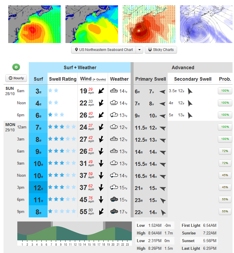
Much as we did last year as Hurricane Irene bore down on New York City, we hereby present the surf forecast for the entrance to New York Bay, courtesy of MagicSeaweed:

MagicSeaweed surf forecast for The Cove on Monday October 29th 2012
More on Storm Surge Shuts the Subway in New York
Filed under Disasters by Jim Hunt
In the good old days I used to pore over atmospheric pressure charts kindly provided online by the likes of the European Centre for Medium-Range Weather Forecasts (ECMWF for short) before making a decision on exactly where and when to go surfing. Here's what they are revealing to me today:
More on How Global Warming Causes Bugs on British Beaches
Tags: Arctic, Bude, e-coli, ECMWF, Floods, Jennifer Francis, Met Office, MSW, NCEP, NOAA, SAS, Surfing, Videos, Woolacombe
Filed under Climate by Jim Hunt
Unfortunately the weekend's forecast for the future of Hurricane Jova seems to be have been quite accurate. According to Reuters this morning:
Jova will make landfall on Tuesday afternoon or evening to the northwest of Manzanillo near the resort towns of Melaque and Barra de Navidad, on a stretch of coast dotted with beaches south of Puerto Vallarta.
More on Hurricane Jova to Pound Tourists and Mexico's Biggest Container Port
Filed under Disasters by Jim
Back in January the Association of Surfing Professionals announced their controversial decision to hold:
The first-ever ASP World Tour stop on the East Coast of the United States, set to take place on Long Island’s Long Beach from September 4-15. The event will offer a $1 million dollar prize purse to competitors, an amount unprecedented in professional surfing.
According to the initial press release:
More on Surfing Professionals at Long Beach Look Forward to Katia's Swell
Filed under Disasters by Jim
In their 8 AM EDT public advisory bulletin the National Hurricane Centre say that the:
CENTER OF IRENE NEARING NEW YORK CITY
whilst the warnings they issued at 2 AM remain much the same. The models used by surf forecasting website MagicSeaweed suggest that the eye of the storm is currently passing almost directly over New York City, accompanied by strong onshore winds:
More on Centre of Irene Nearing New York City – Oyster Creek Reactor Shut Down
Filed under Disasters by Jim
This morning's first public advisory bulletin from the National Hurricane Center places the eye of Hurricane Irene "About 195 miles south-southwest of New York City" and warns that:
AN EXTREMELY DANGEROUS STORM SURGE WILL RAISE WATERLEVELS BY AS MUCH AS 4 TO 8 FEET ABOVE GROUND LEVEL WITHIN THE HURRICANE WARNING AREA FROM THE NORTH CAROLINA/VIRGINIA BORDER NORTHWARD TO CAPE COD INCLUDING SOUTHERN PORTIONS OF THE CHESAPEAKE BAY AND ITS TRIBUTARIES. NEAR THE COAST THE SURGE WILL BE ACCOMPANIED BY LARGE DESTRUCTIVE AND LIFE-THREATENING WAVES. HIGHER THAN NORMAL ASTRONOMICAL TIDES ARE OCCURRING THIS WEEKEND. COASTAL AND RIVER FLOODING WILL BE HIGHEST IN AREAS WHERE THE PEAK SURGE OCCURS AROUND THE TIME OF HIGH TIDE. STORM TIDE AND SURGE VALUES ARE VERY LOCATION-SPECIFIC AND USERS ARE URGED TO CONSULT PRODUCTS ISSUED BY THEIR LOCAL NATIONAL WEATHER SERVICE OFFICES.
More on Storm Surge and Tornados From Hurricane Irene Threaten New York
Filed under Disasters by Jim
