October 4, 2013
US Gulf Coast on Hurricane Watch
The National Hurricane Center is one of the few US Government agencies still working normally during the current "shutdown". As they point out on their web site:
Due to the Federal Government shutdown, NOAA.gov and most associated web sites are unavailable. However, because the information this site provides is necessary to protect life and property, it will be updated and maintained during the Federal Government shutdown.
In a public advisory bulletin issued at 13:00 UTC yesterday the NHC reported that Tropical Storm Karen had formed. In their most recent bulletin about Karen at 09:00 UTC this morning they say about her that:
LOCATION: 24.9N 89.8W, ABOUT 295 MI (470 KM) S OF THE MOUTH OF THE MISSISSIPPI RIVER.
MAXIMUM SUSTAINED WINDS: 60 MPH (95 KM/H)
PRESENT MOVEMENT: NW OR 325 DEGREES AT 10 MPH (17 KM/H)
MINIMUM CENTRAL PRESSURE: 1002 MB (29.59 INCHES)A HURRICANE WATCH IS IN EFFECT FOR…
* GRAND ISLE LOUISIANA TO WEST OF DESTIN FLORIDAA TROPICAL STORM WARNING IS IN EFFECT FOR…
* GRAND ISLE LOUISIANA TO THE MOUTH OF THE PEARL RIVERA TROPICAL STORM WATCH IS IN EFFECT FOR…
* WEST OF GRAND ISLE TO EAST OF MORGAN CITY LOUISIANA
* METROPOLITAN NEW ORLEANS
* LAKE MAUREPAS
* LAKE PONTCHARTRAIN
* DESTIN TO INDIAN PASS FLORIDAINTERESTS ELSEWHERE IN THE NORTHERN AND NORTHEASTERN COASTS OF THE
GULF OF MEXICO SHOULD MONITOR THE PROGRESS OF KAREN.
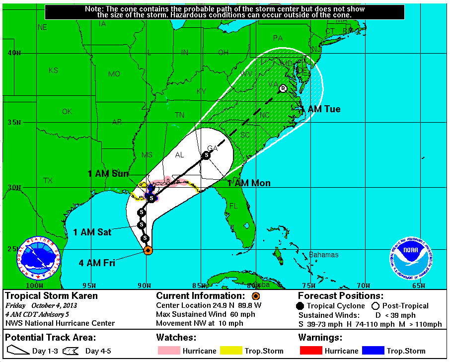
Here's Karen's current forecast track for the next 5 days:
As you can see, at the moment she is forecast to cross the Gulf coast without quite reaching hurricane intensity. Nevertheless, the NHC bulletin goes on to say:
HURRICANE CONDITIONS ARE POSSIBLE WITHIN PORTIONS OF THE HURRICANE WATCH AREA ON SATURDAY OR SATURDAY NIGHT. TROPICAL STORM CONDITIONS ARE EXPECTED WITHIN PORTIONS OF THE TROPICAL STORM WARNING AREA BY TONIGHT OR SATURDAY MORNING.
THE COMBINATION OF STORM SURGE AND THE TIDE WILL CAUSE NORMALLY DRY AREAS NEAR THE COAST TO BE FLOODED BY RISING WATERS.
KAREN IS EXPECTED TO PRODUCE RAINFALL AMOUNTS OF 4 TO 8 INCHES OVER PORTIONS OF THE CENTRAL AND EASTERN GULF COAST THROUGH SUNDAY NIGHT…MAINLY NEAR AND TO THE RIGHT OF THE PATH OF THE CENTER. ISOLATED STORM TOTAL AMOUNTS OF 12 INCHES ARE POSSIBLE.
Filed under Disasters by

Comments on US Gulf Coast on Hurricane Watch »
This morning (UTC) the Hurricane Watch has been removed, and the predicted effects of Karen's passage over the Gulf states are now less severe. According to the latest NHC bulletin about Karen:
This afternoon (UTC) the National Hurricane Center issued their last public advisory bulletin for Karen. they say that:
Weather.gov currently says that: