October 27, 2012
Hurricane Sandy Morphs Into The Bride of Frankenstorm
Since we first reported on Hurricane Sandy she slightly surprisingly left the north coast of Cuba as a category 2 hurricane, with maximum sustained winds of 105 mph. According to Associated Press she then:
Raged through the Bahamas early Friday after leaving 38 people dead across the Caribbean
Here's their "raw video" of what happened in the Bahamas:
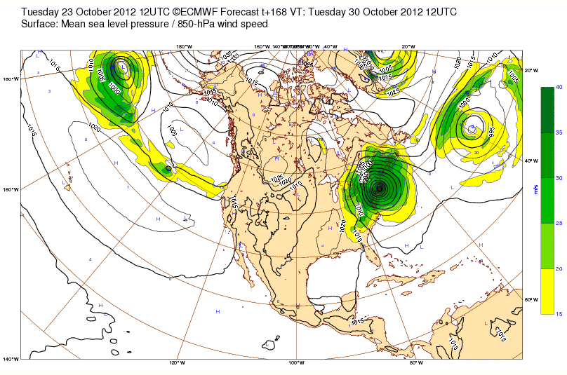
Last Wednesday the various models used by the forecasters weren't in agreement about what was likely to happen next week. The official forecast from the National Hurricane Center suggested that Sandy would head harmlessly off across the North Atlantic, whereas the European Centre for Medium-Range Weather Forecasts model seemed convinced that Sandy was headed for the east coast of the United States:
However by yesterday the NHC were agreeing that the US Atlantic coast should expect a hefty pounding, with the most likely outcome being the eye of a hurricane arriving on the Delmarva Peninsula at around 2 AM on Tuesday morning:
By this morning (UK time) the BBC are reporting that:
Hurricane Sandy could merge with a winter storm to create what they have dubbed "Frankenstorm" as it churns towards the US, forecasters warn. Sandy has weakened to a category one hurricane, but is still packing maximum sustained winds of 75mph (120km/h). The storm is projected to hit the US late on Monday, a week before the presidential election.
States of emergency have been declared in Maryland, New York, Pennsylvania, Virginia, Washington and a coastal county in North Carolina. The US Navy base in Norfolk, Virginia was reportedly sending a whole fleet of ships out to sea to avoid the storm.
In New York City, officials are already considering closing down mass transit before the storm hits. Mayor Michael Bloomberg urged calm, after activating the city's coastal storm plan.
The BBC and the forecasters they mention seem to be slightly confused about a number of things, not least of which is Sandy's gender. He is in fact a she, since NASA seem more than happy to point out that:
The storm is expected to couple with a powerful cold front and Arctic air to bring that heavy rainfall to the Mid-Atlantic and northeastern U.S. Some forecasters are calling this combination of weather factors "Frankenstorm" because of the close proximity to Halloween. However, Sandy is a woman's name, the storm could be considered a "bride of Frankenstorm."
Meanwhile, overnight the blushing bride weakened to tropical storm force, but according to the latest public advisory bulletin from the NHC:
AIR FORCE AIRCRAFT FINDS HURRICANE-FORCE WINDS AGAIN. SANDY HAS MAXIMUM SUSTAINED WINDS NEAR 75 MPH, WITH HIGHER GUSTS. LITTLE OVERALL CHANGE IN STRENGTH IS FORECAST DURING THE NEXT FEW DAYS.
SANDY IS A VERY LARGE TROPICAL CYCLONE. HURRICANE FORCE WINDS EXTEND OUTWARD UP TO 100 MILES PRIMARILY SOUTHWEST OF THE CENTER, AND TROPICAL STORM FORCE WINDS EXTEND OUTWARD UP TO 450 MILES FROM THE CENTER.
For yet another view of exactly where Sandy might be heading next week you may wish to peruse the NOAA's GOES-R/JPSS blog, which is currently analysing Sandy on the basis of some images from the "The future of weather satellites!". Following:
The model mayhem we have all been hearing about or observing
they suggest that:
The North Atlantic has gotten more complicated as the higher latitude blocking is in full swing. [An] expanding area of upper-level high pressure or ridge is setting up this “blocky pattern”. The traffic jam has started and the large, complex ocean storm with two significant shortwaves will shift southeast over the weekend, then sit and spin. . .for a while. This helps to strengthen the ridge to the north and will lead to a road-block with subsequent detour for Sandy. So, blame Greenland for being a favored location for things like this!
Filed under Disasters by


Leave a Comment