October 11, 2011
Hurricane Jova to Pound Tourists and Mexico's Biggest Container Port
Unfortunately the weekend's forecast for the future of Hurricane Jova seems to be have been quite accurate. According to Reuters this morning:
Jova will make landfall on Tuesday afternoon or evening to the northwest of Manzanillo near the resort towns of Melaque and Barra de Navidad, on a stretch of coast dotted with beaches south of Puerto Vallarta.
"We expect it to be really strong," said Irma Joya, owner of a souvenir shop on the main boardwalk in Puerto Vallarta, a popular tourist destination where residents braced for waves up to 13 feet high. "We have experience with hurricanes so there is a culture of prevention here," she said as she boarded up her shop with wooden planks on Monday evening.
Authorities planned to evacuate low-lying areas.
Manzanillo, Mexico's main point of arrival for cargo containers, has been closed since late Sunday and about 13 container ships are stuck in the port.
An official said shipments that were held up because of the lock-down, included 15,000 tonnes of sugar from Colombia, 16,000 tonnes of imported rolled steel and a shipment of iron pellets for domestic use.
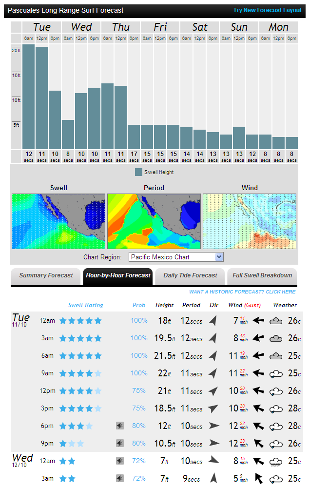
According to the latest forecast from the MagicSeaweed surf forecasting website the waves later today will be even bigger than Irma is anticipating:
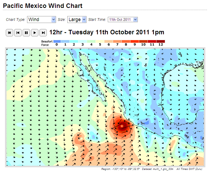
and here is MSW's forecast for the winds later today:

MagicSeaweed wind forecast for the Pacific coast of Mexico at 12:00 UTC on Tuesday October 11th 2011
In their most recent public advisory bulletin the National Hurricane Center put the prognosis this way:
JOVA TAKING AIM ON SOUTHWEST MEXICO.
A HURRICANE WARNING IS IN EFFECT FOR…
* PUNTA SAN TELMO NORTHWARD TO CABO CORRIENTES MEXICOA TROPICAL STORM WARNING IS IN EFFECT FOR…
* LAZARO CARDENAS NORTHWARD TO SOUTH OF PUNTA SAN TELMO MEXICO
* NORTH OF CABO CORRIENTES TO EL ROBLITO MEXICOHAZARDS AFFECTING LAND
———————-
WIND – TROPICAL STORM CONDITIONS ARE EXPECTED TO REACH THE COAST OF MEXICO WITHIN THE SOUTHERN PORTION OF THE WARNING AREA THIS MORNING. HURRICANE CONDITIONS ARE FORECAST TO REACH THE COAST WITHIN THE HURRICANE WARNING AREA BY THIS AFTERNOON.STORM SURGE – A DANGEROUS STORM SURGE IS EXPECTED TO PRODUCE SIGNIFICANT COASTAL FLOODING NEAR AND TO THE EAST OF WHERE THE CENTER MAKES LANDFALL. NEAR THE COAST THE SURGE WILL BE ACCOMPANIED BY LARGE AND DESTRUCTIVE WAVES.
RAINFALL – JOVA IS EXPECTED TO PRODUCE TOTAL RAINFALL ACCUMULATIONS OF 6 TO 12 INCHES OVER THE STATES OF MICHOACAN, COLIMA, JALISCO AND NAYARIT, WITH POSSIBLE ISOLATED MAXIMUM AMOUNTS OF 20 INCHES. THESE RAINS COULD CAUSE LIFE-THREATENING FLASH FLOODS AND MUD SLIDES OVER MOUNTAINOUS TERRAIN.
SURF – SWELLS GENERATED BY JOVA ARE AFFECTING PORTIONS OF THE COAST OF SOUTHWESTERN MEXICO. THESE SWELLS ARE LIKELY TO CAUSE LIFE-THREATENING SURF AND RIP CURRENT CONDITIONS.
If you would like to watch events unfold later today on the Pacific coast of Mexico from a safe distance, here is a live view (currently at least) of the beach at Puerto Vallarta. If that is a luxury you and your family cannot afford, please take very great care over the next 24 hours.
Filed under Disasters by

Leave a Comment