May 9, 2015
Early Start to 2015 Atlantic Hurricane Season
The Atlantic hurricane season officially runs from June 1st until November 30th. Last year the first named storm of the season was called Arthur and he formed on July 1st. This year the first storm of the 2015 season is called Ana, and the United States National Hurricane Center first mentioned the as yet unnamed storm on May 3rd 2015:
A non-tropical area of low pressure is expected to form north of the Bahamas later this week. This system could gradually acquire some subtropical characteristics by Thursday or Friday as it moves slowly northward.
* Formation chance through 48 hours…low…near 0 percent
* Formation chance through 5 days…low…30 percent
Despite those low probabilities the NHC issued their first public advisory message for Ana late on May 7th:
SUBTROPICAL STORM ANA FORMS OFF THE SOUTHEAST U.S. COAST…
SUMMARY OF 1100 PM EDT…0300 UTC…INFORMATION
———————————————–
LOCATION…31.5N 77.6W
ABOUT 170 MI…275 KM SSE OF MYRTLE BEACH SOUTH CAROLINA
MAXIMUM SUSTAINED WINDS…45 MPH…75 KM/H
PRESENT MOVEMENT…N OR 350 DEGREES AT 2 MPH…4 KM/H
MINIMUM CENTRAL PRESSURE…1004 MB…29.65 INCHESA TROPICAL STORM WATCH HAS BEEN ISSUED FROM EDISTO BEACH SOUTH CAROLINA TO CAPE LOOKOUT NORTH CAROLINA.
Ana formed unusually early, and is in fact the earliest named Atlantic tropical cyclone since another Ana in 2003. By this morning she had acquired the characteristics of a fully fledged tropical storm. According to the NHC once again:
ANA TRANSITIONS TO A TROPICAL STORM WHILE IT MOVES SLOWLY NORTH-NORTHWESTWARD TOWARD THE CAROLINAS…
SUMMARY OF 500 AM EDT…0900 UTC…INFORMATION
———————————————-
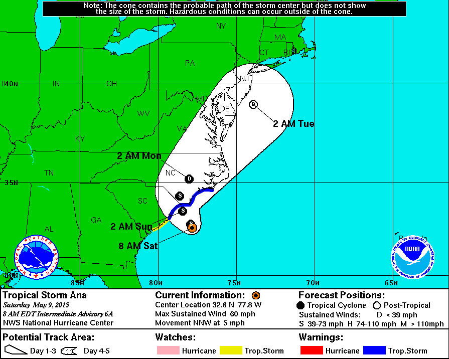
LOCATION…32.4N 77.6W
ABOUT 105 MI…170 KM SSE OF CAPE FEAR NORTH CAROLINA
ABOUT 115 MI…190 KM SE OF MYRTLE BEACH SOUTH CAROLINA
MAXIMUM SUSTAINED WINDS…60 MPH…95 KM/H
PRESENT MOVEMENT…NNW OR 340 DEGREES AT 3 MPH…6 KM/H
MINIMUM CENTRAL PRESSURE…998 MB…29.47 INCHESA Tropical Storm Warning is in effect for: South Santee River South Carolina to Cape Lookout
A Tropical Storm Watch is in effect for: Edisto Beach South Carolina to South of South Santee RiverHAZARDS AFFECTING LAND
———————-
WIND: Tropical storm conditions are expected within the warning area, and possible within the watch area, by this afternoon or evening.STORM SURGE: The combination of storm surge and the tide will cause normally dry areas near the coast to be flooded by rising waters. The water could reach 1 to 2 ft above ground at times of high tide in coastal areas from Cape Hatteras, North Carolina southward through South Carolina. For information specific to your area, please see products issued by your local National Weather Service forecast office.
RAINFALL: Tropical Storm Ana is expected to produce rainfall accumulations of 1 to 3 inches, with isolated amounts of 5 inches, over eastern portions of North Carolina and South Carolina through Monday.
SURF: Swells generated by Ana are affecting portions of the southeastern U.S. coast. These swells will likely cause life-threatening surf and rip currents. Please see statements issued by your local National Weather Service forecast office.
Here is Ana's current forecast track:
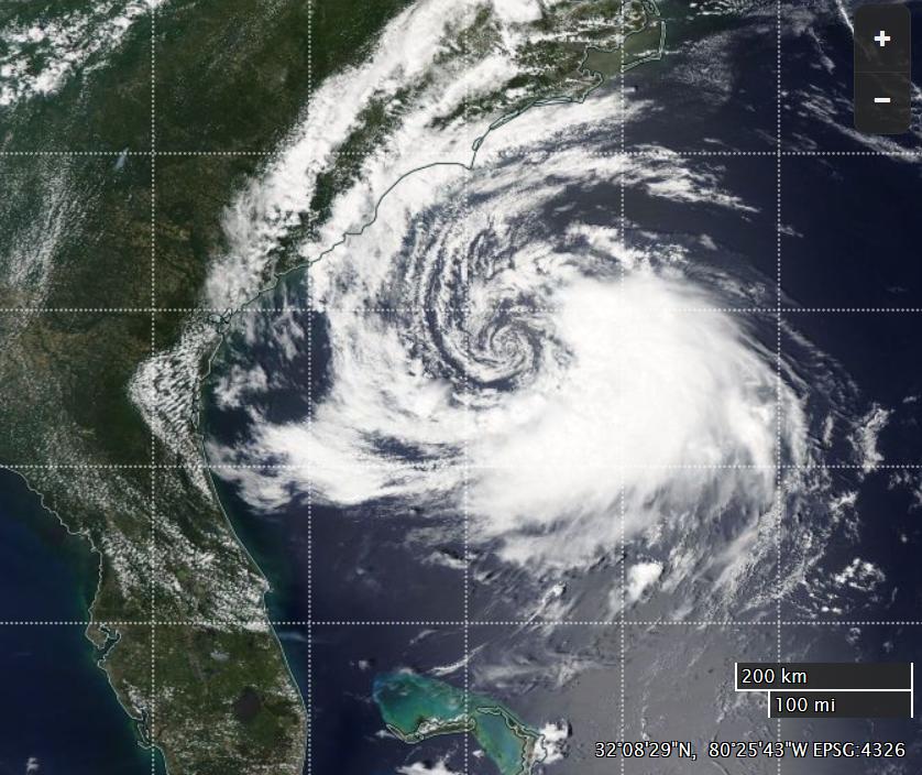
And here's what she looked like yesterday from on high, in a "true color" image derived from the MODIS instrument on the Aqua satellite:

NASA Worldview “true-color” image of Tropical Storm Ana on May 8th, derived from bands 1, 4 and 3 of the MODIS sensor on the Aqua satellite
If the forecasts are accurate Ana isn't going to turn into a hurricane, but nonetheless she is certainly going to cause a few problems for the inhabitants of the coast of the Carolinas.
Filed under Climate by

Comments on Early Start to 2015 Atlantic Hurricane Season »
Ana has now made landfall between Myrtle Beach and North Myrtle Beach on the coast of South Carolina. According to the NHC at 06:00 EDT:
According to a "tweet" that I've just read:
I felt compelled to quibble with that assertion:
https://twitter.com/jim_hunt/status/597378279323136000
Here's why: