August 28, 2011
Storm Surge and Tornados From Hurricane Irene Threaten New York
This morning's first public advisory bulletin from the National Hurricane Center places the eye of Hurricane Irene "About 195 miles south-southwest of New York City" and warns that:
AN EXTREMELY DANGEROUS STORM SURGE WILL RAISE WATERLEVELS BY AS MUCH AS 4 TO 8 FEET ABOVE GROUND LEVEL WITHIN THE HURRICANE WARNING AREA FROM THE NORTH CAROLINA/VIRGINIA BORDER NORTHWARD TO CAPE COD INCLUDING SOUTHERN PORTIONS OF THE CHESAPEAKE BAY AND ITS TRIBUTARIES. NEAR THE COAST THE SURGE WILL BE ACCOMPANIED BY LARGE DESTRUCTIVE AND LIFE-THREATENING WAVES. HIGHER THAN NORMAL ASTRONOMICAL TIDES ARE OCCURRING THIS WEEKEND. COASTAL AND RIVER FLOODING WILL BE HIGHEST IN AREAS WHERE THE PEAK SURGE OCCURS AROUND THE TIME OF HIGH TIDE. STORM TIDE AND SURGE VALUES ARE VERY LOCATION-SPECIFIC AND USERS ARE URGED TO CONSULT PRODUCTS ISSUED BY THEIR LOCAL NATIONAL WEATHER SERVICE OFFICES.
IRENE IS EXPECTED TO PRODUCE RAINFALL ACCUMULATIONS OF 6 TO 12 INCHES WITH ISOLATED MAXIMUM AMOUNTS OF 20 INCHES FROM EASTERN NORTH CAROLINA NORTHWARD THROUGH THE MID-ATLANTIC STATES INTO EASTERN NEW YORK AND INTERIOR NEW ENGLAND. THESE RAINS COMBINED WITH HEAVY RAINS OVER THE PAST FEW WEEKS COULD CAUSE WIDESPREAD FLOODING,LIFE-THREATENING FLASH FLOODS AND SIGNIFICANT UPROOTING OF TREES DUE TO RAIN-SOFTENED GROUNDS.
ISOLATED TORNADOES ARE POSSIBLE OVER SOUTHERN DELAWARE, EASTERN NEW JERSEY, SOUTHEASTERN NEW YORK AND EXTREME SOUTHERN NEW ENGLAND THROUGH THIS MORNING.
WINDS AFFECTING THE UPPER FLOORS OF HIGH-RISE BUILDINGS WILL BE SIGNIFICANTLY STRONGER THAN THOSE NEAR GROUND LEVEL.
According to The Independent newspaper:
Mandatory evacuations have been ordered for 370,000 New Yorkers who live mostly in low-lying areas. The unprecedented orders, which affect New Yorkers from Manhattan and out to the beaches of Brooklyn and Queens, dealt the congested metropolis a formidable logistical challenge that raised more questions than it resolved.
Some questioned where all the people in New York's flood-prone areas were supposed to go and, more pointedly, how they were going to get there since many do not own a car.
According to New York Mayor, Michael Bloomberg, he was confident people would get out of the storm's way:
We do not have the manpower to go door-to-door and drag people out of their homes," he said. "Nobody's going to get fined. Nobody's going to go to jail. But if you don't follow this, people might die.
However Texas meteorologist John Nielsen-Gammon didn't sound as sure as Mayor Bloomberg about that:
It's possible to evacuate without going very far. The big wild card for New York is the fact that nobody there is used to a hurricane and can't rely on common sense or past experience as a guide. And what we learned from evacuations in Houston is that people rely on their friends and their own experience as much as, or more than, they rely on public officials.
Should any of your friends ask you whether staying around to watch is a good idea, I suggest that you recommend that they listen carefully to Michael Bloomberg and if at all possible comply with his suggestions. This is what hurricanes can do:
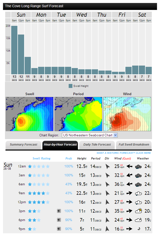
and here is the surf forecast for New York City for today, courtesy of MagicSeaweed:
Finally, here is AP's most recent video on the current emergency:
Filed under Disasters by

Leave a Comment