October 2, 2016

Hurricane Matthew Aims At Haiti

It's a long time since the 2016 Atlantic hurricane season started way back in January as Hurricane Alex headed for Greenland.

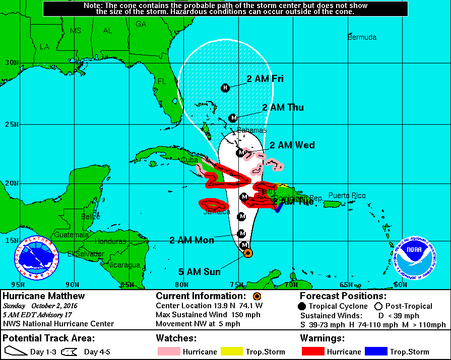
Today we bring you news of Hurricane Matthew, who swept through the Lesser Antilles into the Caribbean Sea as a mere tropical storm but has now turned north and strengthened into a major hurricane. Matthew briefly reached category 5 status yesterday with sustained wind speeds of 160 miles per hour, but those winds have dropped down to a mere 150 mph this morning. Like Alex, Matthew has several claims to fame, most notably as the southernmost category 5 hurricane ever recorded in the Atlantic, at 13.3° north. Here's the current forecast from the National Hurricane Center:

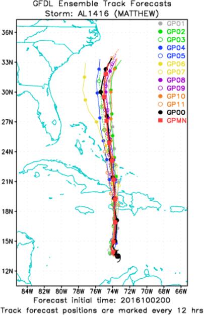
As you can see, there are hurricane warnings already in place for Jamaica, Cuba, and Haiti. There is always some uncertainty over the forecast track of any hurricane. In this case that can be gauged by looking at the current NOAA Geophysical Fluid Dynamics Laboratory ensemble forecast for Matthew:

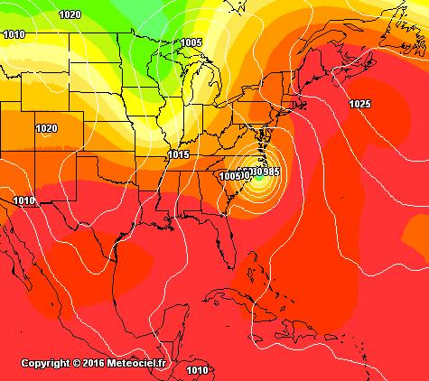
At the moment it seems highly likely that Matthew's eye will pass over western Haiti before passing close to or over Eastern Cuba and then heading in the general direction of the east coast of the United States. It's far too early to say with certainty whether Matthew will make landfall on the mainland of the United States of America, but here is the Global Forecast System's best guess for 138 hours from 6 AM this morning:

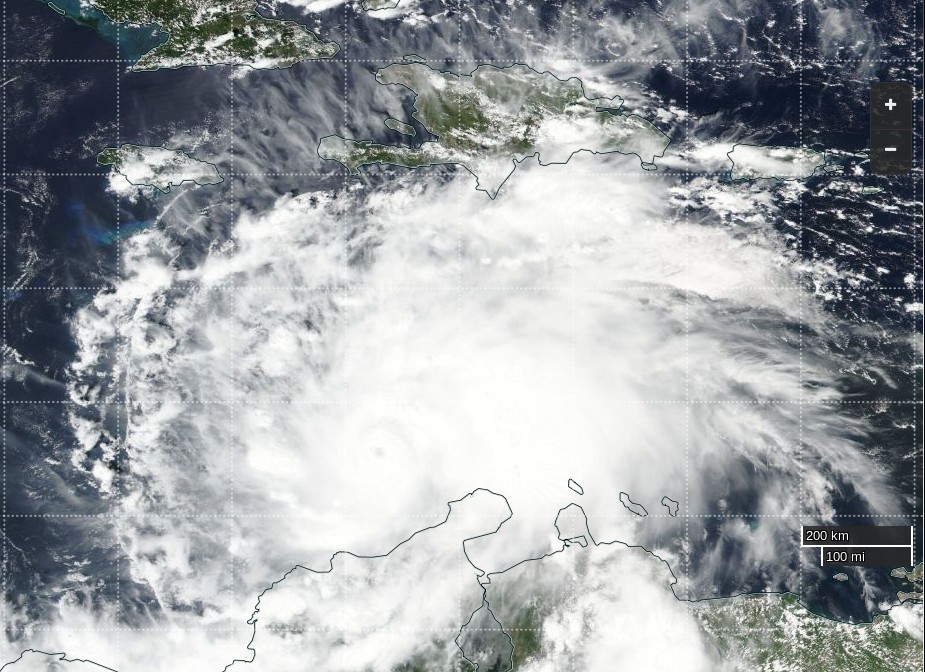
Here's how Matthew looked from the Suomi satellite yesterday afternoon:

Filed under Disasters by
Comments on Hurricane Matthew Aims At Haiti »

October 2, 2016

Jim Jim @ 1:48 pm

Here's the latest Matthew ensemble:

He's edging closer to the eastern seaboard.

Jim Jim @ 5:49 pm

The latest image of Matthew from space, this time courtesy of the MODIS instrument aboard the Terra satellite:

Jim Jim @ 9:49 pm

The latest NHC forecast track for Matthew:

and the latest GFDL ensemble forecast:

October 3, 2016

Jim Jim @ 8:54 am

Hurricane Matthew has passed over a NOAA buoy in the Caribbean:

I make 27.87 inches of mercury equal to 944 hPa. Here too are the latest NHC forecast track:

and GFDL ensemble forecast:

This morning the mainstream media have started to mention Haiti in their headlines. According to the BBC:

One of the most powerful Atlantic hurricanes in recent years has been moving across the Caribbean towards Jamaica, Haiti and eastern Cuba.

Parts of Jamaica have already been lashed by rain and strong winds, with flood waters blocking roads in the capital, Kingston.

A hurricane warning is in place for Haiti, which is expected to be more seriously affected.

The category-four hurricane is due to bring up to 64 cm (25 inches) of rain.

That in turn could trigger life-threatening landslides and floods.

The Haitian authorities have urged people to stock up on food and water and secure their homes. Thousands are still living in tents following the huge earthquake in 2010.

Jim Jim @ 4:33 pm

The latest updates reveal an increased likelihood that the eye of Matthew may just miss Western Haiti, but make landfall in North Carolina:

Even if Haiti escapes a direct hit from Matthew, the forecast is still awful:

1100 AM EDT MON OCT 03 2016

…POWERFUL HURRICANE MATTHEW EXPECTED TO BRING LIFE-THREATENING RAIN…WIND…AND STORM SURGE TO PORTIONS OF HAITI…

SUMMARY OF 1100 AM EDT…1500 UTC…INFORMATION
———————————————–
LOCATION…15.6N 75.0W
ABOUT 275 MI…440 KM SW OF PORT AU PRINCE HAITI
ABOUT 205 MI…330 KM SE OF KINGSTON JAMAICA
MAXIMUM SUSTAINED WINDS…140 MPH…220 KM/H
PRESENT MOVEMENT…N OR 360 DEGREES AT 6 MPH…9 KM/H
MINIMUM CENTRAL PRESSURE…941 MB…27.79 INCHES

SUMMARY OF WATCHES AND WARNINGS IN EFFECT:

A Hurricane Warning is in effect for…
* Jamaica
* Haiti
* Cuban provinces of Guantanamo, Santiago de Cuba, Holguin, Granma, and Las Tunas
* Southeastern Bahamas, including the Inaguas, Mayaguana, Acklins, Crooked Island, Long Cay, and Ragged Island

A Hurricane Watch is in effect for…
* Cuban province of Camaguey
* Turks and Caicos Islands
* Central Bahamas, including Long Island, Exuma, Rum Cay, San Salvador, and Cat Island

A Tropical Storm Warning is in effect for…
* Dominican Republic from Barahona westward to the border with Haiti

A Tropical Storm Watch is in effect for…
* Dominican Republic from Puerto Plata westward to the border with Haiti

RAINFALL: Matthew is expected to produce total rainfall amounts in the following areas:

Southern Haiti and southwestern Dominican Republic…15 to 25 inches, isolated 40 inches
Eastern Cuba and northwestern Haiti…8 to 12 inches, isolated 20 inches
Eastern Jamaica…5 to 10 inches, isolated 15 to 20 inches

Life-threatening flash floods and mudslides are likely from this rainfall in southern and northwestern Haiti, the southwestern Dominican Republic, and eastern Cuba.

STORM SURGE: The combination of a dangerous storm surge and large and destructive waves could raise water levels by as much as the following amounts above normal tide levels…

Southern Coast of Cuba east of Cabo Cruz…7 to 11 feet
South Coast of Haiti…7 to 10 feet

Jim Jim @ 9:51 pm

The latest forecasts show Matthew's track edging ever closer to Florida:

October 4, 2016

Jim Jim @ 9:07 am

The latest public advisory bulletin from the NHC states that:

At 500 AM EDT (0900 UTC), the center of Hurricane Matthew was located near latitude 17.8 North, longitude 74.4 West. Matthew is moving toward the north near 9 mph (15 km/h) and this general motion is expected to continue today. A turn toward the north-northwest is expected by Wednesday, followed by a northwest turn Wednesday night. On the forecast track, the center of Matthew will pass near or over southwestern Haiti during the next few hours, move near eastern Cuba later today, and move near or over portions of the southeastern and central Bahamas tonight and Wednesday, and approach the northwestern Bahamas Wednesday night

Maximum sustained winds are near 145 mph (230 km/h) with higher gusts. Some fluctuations in intensity are possible during the next couple of days, but Matthew is expected to remain a powerful hurricane through at least Wednesday night.

Hurricane-force winds extend outward up to 40 miles (65 km) from the center and tropical-storm-force winds extend outward up to 185 miles (295 km).

The estimated minimum central pressure is 934 mb (27.58 inches).

The latest track forecasts suggest that the United States should now also expect some severe weather, and possibly also landfall:

Jim Jim @ 2:13 pm

Interim update 25A from the NHC reports that:

800 AM EDT TUE OCT 04 2016

…EYE OF EXTREMELY DANGEROUS HURRICANE MATTHEW MADE LANDFALL NEAR LES ANGLAIS IN WESTERN HAITI AT 7 AM EDT THIS MORNING…

LOCATION…18.4N 74.2W
ABOUT 10 MI…15 KM E OF TIBURON HAITI
ABOUT 125 MI…200 KM S OF THE EASTERN TIP OF CUBA
MAXIMUM SUSTAINED WINDS…145 MPH…230 KM/H
PRESENT MOVEMENT…N OR 5 DEGREES AT 9 MPH…15 KM/H
MINIMUM CENTRAL PRESSURE…934 MB…27.58 INCHES

A report on Matthew's arrival in Haiti from Al Jazeera:

October 5, 2016

Jim Jim @ 10:45 am

Last night's update 27A from the NHC reported:

800 PM EDT TUE OCT 04 2016

THE EYE OF POWERFUL HURRICANE MATTHEW MAKING LANDFALL NEAR THE EASTERN TIP OF CUBA

LOCATION…20.1N 74.3W
ABOUT 15 MI…20 KM SW OF THE EASTERN TIP OF CUBA
ABOUT 55 MI…90 KM ENE OF GUANTANAMO CUBA
MAXIMUM SUSTAINED WINDS…140 MPH…220 KM/H
PRESENT MOVEMENT…N OR 360 DEGREES AT 9 MPH…15 KM/H
MINIMUM CENTRAL PRESSURE…949 MB…28.03 INCHES

A Hurricane Warning is in effect for…
* Haiti
* Cuban provinces of Guantanamo, Santiago de Cuba, Holguin, Granma, and Las Tunas
* Southeastern Bahamas, including the Inaguas, Mayaguana, Acklins, Crooked Island, Long Cay, and Ragged Island
* Central Bahamas, including Long Island, Exuma, Rum Cay, San Salvador, and Cat Island
* Northwestern Bahamas, including the Abacos, Andros Island, Berry Islands, Bimini, Eleuthera, Grand Bahama Island, and New Providence

Here's a satellite image of Matthew taken shortly after his eye had crossed the far west of Haiti:

Jim Jim @ 6:13 pm

Interim update 30A from the NHC reports that:

200 PM EDT WED OCT 05 2016

SEVERE HURRICANE MATTHEW BEARING DOWN ON THE BAHAMAS AND AIMING
TOWARD FLORIDA…

LOCATION…22.1N 75.3W
ABOUT 70 MI…115 KM NNE OF CABO LUCRECIA CUBA
ABOUT 70 MI…115 KM S OF LONG ISLAND BAHAMAS
MAXIMUM SUSTAINED WINDS…120 MPH…195 KM/H
PRESENT MOVEMENT…NW OR 325 DEGREES AT 12 MPH…19 KM/H
MINIMUM CENTRAL PRESSURE…963 MB…28.44 INCHES

A Hurricane Warning is in effect for…
* Cuban provinces of Guantanamo, Santiago de Cuba, Holguin, Granma, and Las Tunas
* Southeastern Bahamas, including the Inaguas, Mayaguana, Acklins, Crooked Island, Long Cay, and Ragged Island
* Central Bahamas, including Long Island, Exuma, Rum Cay, San Salvador, and Cat Island
* Northwestern Bahamas, including the Abacos, Andros Island, Berry Islands, Bimini, Eleuthera, Grand Bahama Island, and New Providence
* North of Golden Beach to the Flagler/Volusia county line
* Lake Okeechobee

The latest NHC forecast track:

and GFDL ensemble forecast:

now suggest that Matthew may hug the US coast all the way from Florida to the Outer Banks of North Carolina.

Meanwhile ShelterBox report from Haiti that:

The category 4 storm hit Haiti with 145mph winds and torrential rains. It is the most powerful storm to affect the island in more than 50 years.

Haiti is one of the world's poorest countries and is only just starting to recover from the catastrophic earthquake. Many homes are made from flimsy materials that can't withstand extreme weather.

The level of damage is not yet know, as some parts of the country are totally cut off, with no means of communication, but initial reports suggest that at least 10,000 people are without proper shelter.

October 7, 2016

Jim Jim @ 10:26 am

According to an ITN news report:

The death toll in Haiti as a result of the most powerful Caribbean storm in a decade has soared to more than 300.

As we have previously reported, cholera is an ever present danger in Haiti. Expect deaths from the disease to far exceed those from the direct consequences of Matthew's passage over the coming months.

October 8, 2016

Jim Jim @ 2:47 pm

According to an Al Jazeera news report:

The number of people killed in Haiti by Hurricane Matthew has risen sharply to at least 842, but that figure is likely to rise as rescue teams access more remote areas.

Government and UN officials estimate that some 350,000 people need urgent help.

One of the biggest fears is the spread of cholera. Thousands of people have already died because of this disease. In this room there are 12 people with cholera. 5 of them are children. This Friday morning one of them died.

Here's the situation on the ground in Jérémie, the "City of Poets":

Here are the latest annual cholera statistics from the Haitian Ministry of Health, dated September 25th 2016:

Total Deaths: 9434

Leave a Comment

Fields marked by an asterisk (*) are required.

Subscribe without commenting