October 28, 2012
Storm Surge Shuts the Subway in New York
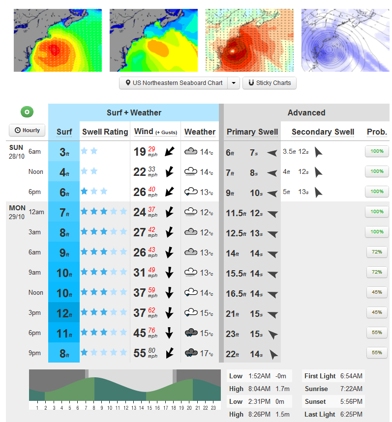
Much as we did last year as Hurricane Irene bore down on New York City, we hereby present the surf forecast for the entrance to New York Bay, courtesy of MagicSeaweed:
As you can see, the forecast at the moment is for swell 23 feet high arriving at the same time as high tide tomorrow evening. Roughly the same predicted height as last year, but with the swell direction more directly onshore and a somewhat longer period.
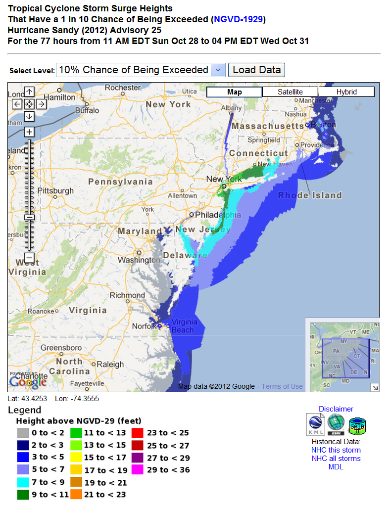
The National Hurricane Center also provides some data on what the Atlantic Ocean is likely to be doing in the same place at the same time tomorrow. Here's how their storm surge height "forecast" looks at the moment:
Note that I put the word "forecast" in quotes, because this isn't the sort of forecast you're probably used to. If you follow the link and zoom in you'll discover that (for the moment at least) the NHC's models suggest there is a 10% chance that a storm surge greater than 11 feet will hit Manhattan at some point over the next three days. By all means try experimenting with the various probabilities.
The latest NHC public advisory bulletin for Hurricane Sandy currently says that:
SANDY EXPECTED TO BRING LIFE-THREATENING STORM SURGE FLOODING TO THE MID-ATLANTIC COAST, INCLUDING LONG ISLAND SOUND AND NEW YORK HARBOR.
IN ADDITION HURRICANE-FORCE WINDS ARE EXPECTED ALONG PORTIONS OF THE COAST BETWEEN CHINCOTEAGUE VIRGINIA AND CHATHAM MASSACHUSETTS. THIS INCLUDES THE MIDDLE AND UPPER CHESAPEAKE BAY, DELAWARE BAY AND THE COASTS OF THE NORTHERN DELMARVA PENINSULA, NEW JERSEY, THE NEW YORK CITY AREA, LONG ISLAND, CONNECTICUT AND RHODE ISLAND.
Putting all this information together the authorities in the area are taking a variety of actions. According to the BBC:
New York City's public transport system is to be suspended ahead of the arrival on Monday of Hurricane Sandy. Governor Andrew Cuomo said the subway, bus and train services would shut down from 19:00 (23:00 GMT) on Sunday.
New York Mayor Michael Bloomberg said people needed to start taking action immediately. He said the worst of the storm would hit New York on Monday, but warned that a storm surge expected later on Sunday could do "plenty of damage". The mayor said 375,000 people living in low-lying areas should leave on Sunday.
Here's a speech that US President Barack Obama gave to the Federal Emergency Management Agency earlier today:
Note that at around 00:10 in the video Mr. Obama says that:
This is a serious and big storm. My first message is to all the people across the eastern seaboard and Mid-Atlantic going north, that you need to take this very seriously.
My message to President Obama is to ask, and not for the first time:
When are you going to start taking climate change seriously? Why keep tempting fate? Why don't you "respond big, and respond fast"?
cc: Mitt Romney
Filed under Disasters by


Leave a Comment