March 26, 2016
Storm Katie is Heading Our Way
The Met Office announced yesterday that:
Storm Katie is forecast to affect southern England and south Wales on Easter Monday
Anticipating the development of an area of low pressure, which will affect southern England and south Wales on Easter Monday, The Met Office has decided to name the storm Katie. This will be the 11th named storm since last autumn.
A National Severe Weather Warning for strong winds has been issued, covering much of Easter Monday.
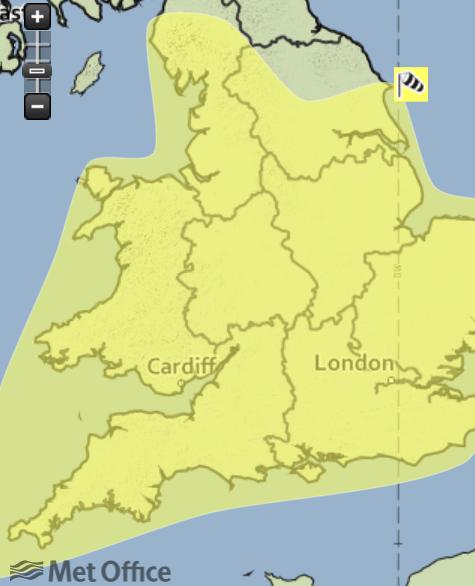
It's currently only Easter Saturday, but we've already had some fairly strong winds in South West England. Here's the Met Office's warning map for today:
The associated warning reads as follows:
A swathe of strong winds, accompanied by a band of heavy rain will move east across England and Wales during Saturday afternoon and early evening. This is expected to bring gusts of 40-50 mph to inland areas, perhaps 60 mph across exposed coasts and hills, as well as on the passage of the cold front, when heavy rain could also produce some very localised surface water flooding.
Please be aware of the possibility of localised low levels of disruption to Easter travel plans and other holiday activities.
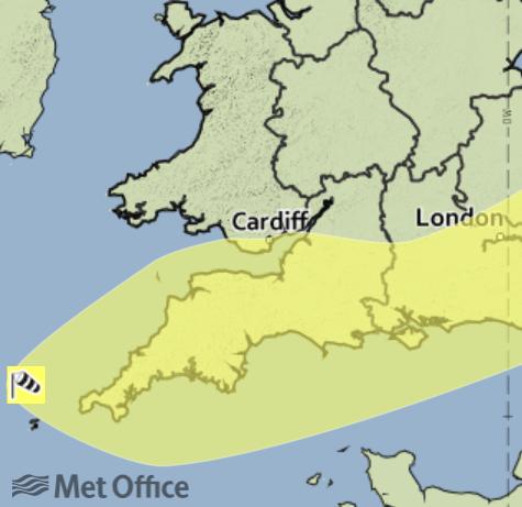
Despite that final sentence there are currently no flood alerts or warnings in place for South West England. Moving on to Easter Monday, the wind warning for Storm Katie only covers Southern England:
Issued at: 1031 on Sat 26 Mar 2016
Valid from: 0115 on Mon 28 Mar 2016
Valid to: 1400 on Mon 28 Mar 2016Winds will strengthen markedly across southern England and through the Bristol Channel from the start of Monday, with the potential for 50-60 mph gusts inland and 70 mph gusts around coasts exposed to the south. Whilst there is a low likelihood of all areas seeing these strong gusts for a time southern coastal counties from Hampshire eastwards look most likely to see the strongest winds. These will then ease from the southwest during the morning, clearing from the east early in the afternoon. Additional hazards may include large waves around exposed coasts as well as a period of heavy rain.
Please be aware of the potential for disruption to outdoor activities and travel, as well as the possibility of fallen trees and temporary interruptions to power supplies.
From the current forecast I can't see that there will be as many "temporary interruptions to power supplies" as "The storm with no name" produced earlier this month. However the Met Office's "Chief Forecaster's assessment" does say that:
There remains a fair amount of uncertainty over the track and timing of this system and so where and when the peaks of strongest winds will occur. However, there is a continuing signal for a period of disruptive winds, perhaps now more focussed towards southeastern parts of England. This alert will be updated on Sunday in light of further information.
More news from us on the forecast for Storm Katie tomorrow.
Filed under Climate by


Comments on Storm Katie is Heading Our Way »
It's now Easter Sunday, and the Met Office has also published a severe weather warning for rain from Storm Katie:
The "Chief Forecaster's assessment" adds that:
The Met Office's severe weather warning for wind hasn't changed significantly from yesterday, although the "Chief Forecaster's assessment" now says that:
The latest GFS forecast via MeteoCiel also suggests that the worst of the winds from Storm Katie will be east of here:
Currently there are still no flood alerts for South West England.
It's now 17:45 BST on Easter Sunday. As Storm Katie approaches there are now 8 flood alerts for South West England:
They include the rivers Dart, Exe, Clyst, Culm, Otter, Sid and Axe.
The latest GFS wind forecast also shows stronger gusts over South Devon than previously. This one's for 5AM on Easter Monday:
The first red flood warning for South West England due to Storm Katie has now been issued, for the River Yarty from Yarcombe to Axminster:
There are now also a total of 22 flood alerts, and almost 1,000 properties have already suffered a power cut:
Storm Katie has now passed over us and according to BBC Radio Devon the road along the ridge of Haldon Hill is currently closed due to fallen trees:
Katie has also done more damage further east. To begin with, there are currently 18 flood warnings across South West England:
Here's Western Power Distribution's current power cut map:
Further east here's Scottish and Southern Energy Power Distribution's power cut map:
and here's one from UK Power Networks' for South East England:
Unlike WPD, SSEPD and UKPN don't publish real time tables of the number of properties without power. SSEPD do however "Live Tweet" about the problems the winds have caused their network: