July 17, 2013
The Arctic Joule Calling
If you recall, the Arctic Joule is a boat that is currently being rowed from Inuvik in northern Canada through the Canadian Arctic Archipelago to Pond Inlet on the north of Baffin Island by a team of four intrepid adventurers, including Kevin Vallely. Earlier this evening I had a long conversation with Kevin, courtesy of the wonders of a satellite telephone. Kevin was in the Arctic Joule's cabin with Frank Wolf, whilst Paul Gleeson and Denis Barnett were rowing. I was sat in an armchair in England!
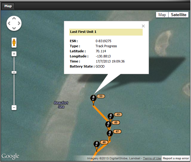
Amongst the many questions I asked was "where are you at the moment?!", since the GPS tracking map on their web site hadn't updated their position for quite some time. Kevin told me they were heading for Cape Dalhousie, and promised to turn on the GPS for a while to confirm that. It seems the system is only turned on intermittently, to leave plenty of joules in the Arctic Joule's batteries for other purposes. Here's what soon popped up on the screen of my laptop:
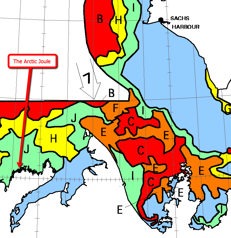
Having established where they were, I enquired about where they were going and how quickly, particularly since there seemed to be considerable quantities of sea ice in their path. Kevin told me their progress had again been hindered by strong northeasterly winds, but that they weren't currently in a desperate rush since all that sea ice would need to clear from Franklin Bay and the start of the Amundsen Gulf before they could attempt to proceed beyond Cape Bathurst. Here's how the Canadian Ice Service map of the Amundsen Gulf looks at the moment, with the approximate position of the Arctic Joule added:
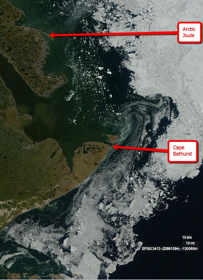
As you can see, the red areas labelled 'C' for 90% concentration of sea ice over 1.2m thick are right in the rowers' path, and currently predicted to drift even further south. You will also note that the Arctic Joule is currently in an area coloured green on the map and labelled 'J' for about 20% concentration. As luck would have it the skies were clear above Cape Bathurst today, so it's also possible to take a look at a satellite's eye view of that sea ice. This image is courtesy of NASA Worldview:
Needless to say I asked Kevin if he'd actually seen any of that sea ice. He told me that whilst they were seeing "ice in the distance more and more" there hadn't been a lot nearby, although the boat had received "an eye-opening thump" from a "partially submerged chunk the size of a dinner table". This naturally led me to ask how the Arctic Joule had coped with this encounter. It seems the vessel survived unscathed, having being sturdily built and shaped similarly to Roald Amundsen's Gjøa, the first ship to successfully navigate the Northwest Passage, to ensure that it would ride up over encroaching sea ice rather than being crushed by it. It seems there is a downside to this method of construction though. The Arctic Joule weighs around 1200 kg, which makes it tough to manhandle through shallow water, or over land or ice. By way of example:
Pushing the rowboat into Tuktoyuktuk – July 12 2013 from Mainstream Last First on Vimeo.
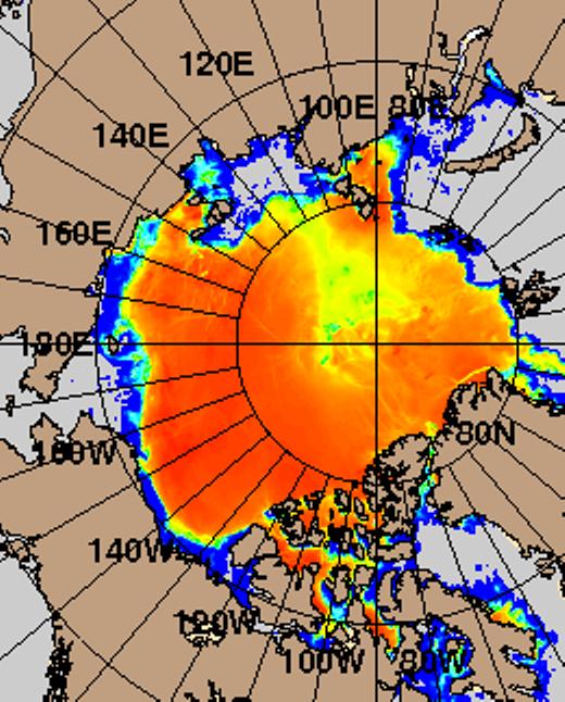
Hoping it might be some sort of a consolation I pointed out that the sort of "wide angle" Arctic sea ice forecasts I look at on a regular basis suggest that the ice in their way would soon be gone:
Assuming that the twin hurdles of wind and ice will soon be crossed, I then asked Kevin about the team's planned route through the Canadian Archipelago, and how quickly they hoped to travel along it. After stopping at Cambridge Bay, the shortest route takes the Arctic Joule north past the western side of King William Island. However if ice conditions there prove too difficult plan 'B' involves taking a longer route via Gjøa Haven. Moving on from direction to speed, I was assured that "on a good day we can cover 75 or even 100 km, but on a bad day we might struggle to do 20 km".
It struck me that a few more "bad days" like those they had already experienced might mean that the long Arctic night would be drawing in by the time they were approaching their ultimate destination. Kevin told me that it's perfectly feasible to keep rowing through the night as long as the moon is out. When it gets too dark just drop anchor!
Kevin and I also discussed a variety of other topics, including fitness, food and drink. More on all that in another article on another day, but for the moment I'll merely add "Bon voyage, Arctic Joule!".
Filed under Adventure by


Comments on The Arctic Joule Calling »
The winds in the Eastern Beaufort Sea are forecast to change to strong westerlies in the near future. Here's the ECMWF wind forecast for next Wednesday, courtesy of MeteoCiel:
If the forecast holds good, there's a big cyclone in store for the Beaufort Sea! At this point in time let's just hope that any winds that do materialise prove strong enough to give the Artic Joule an overdue push in the right direction, but not any stronger.
The westerly winds have kicked in, and the Arctic Joule has now made it across Liverpool Bay.
Their position earlier this morning was 70.06677 N, 128.41635 W