January 13, 2016

Subtropical Storm Alex Arrives in the North Atlantic

Further to our recent news about the unseasonally early formation of Hurricane Pali in the Pacific the National Hurricane Center has just announced that:

OUT OF SEASON SUBTROPICAL STORM FORMS OVER THE FAR EASTERN
ATLANTIC…

SUMMARY OF 500 PM AST…2100 UTC…INFORMATION
———————————————-
LOCATION…27.1N 30.8W
ABOUT 785 MI…1260 KM SSW OF THE AZORES
MAXIMUM SUSTAINED WINDS…50 MPH…85 KM/H
PRESENT MOVEMENT…NE OR 55 DEGREES AT 14 MPH…22 KM/H
MINIMUM CENTRAL PRESSURE…990 MB…29.24 INCHES

The NHC's forecast discussion concerning Alex adds that:

The cyclone is co-located with an upper-level low, and appears to have only a weak warm core, so it is being designated as a subtropical storm.

By 96 hours, the global models show the cyclone merging or becoming absorbed by another extratropical low at high latitudes.

Alex is the first tropical or subtropical storm to form in January since an unnamed system did so in 1978, and is only the fourth known to form in this month in the historical record that begins in 1851.

The NHC suggests that, unlike Pali, Alex may pass near some human habitations:

WATCHES AND WARNINGS
——————–
Interests in the Azores should monitor the progress of Alex.

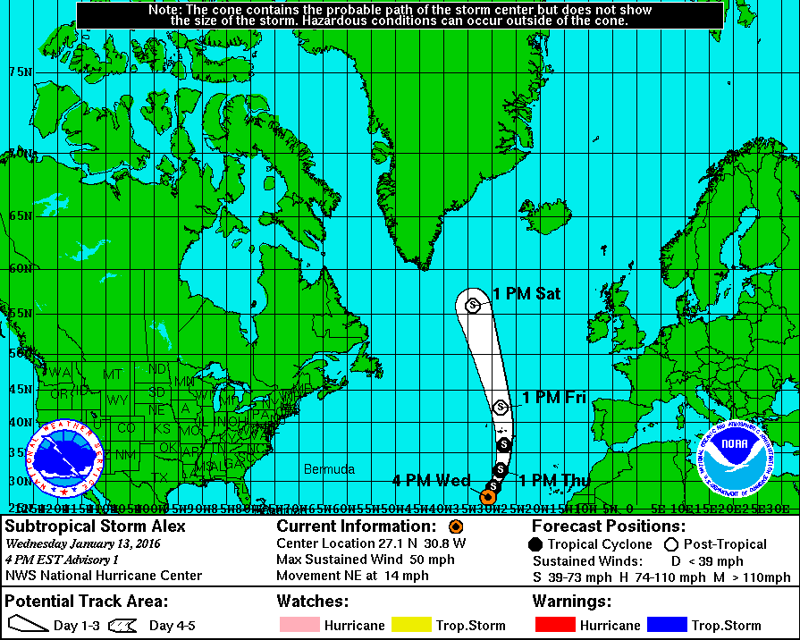
Here's Alex's current forecast track for the next 5 days:

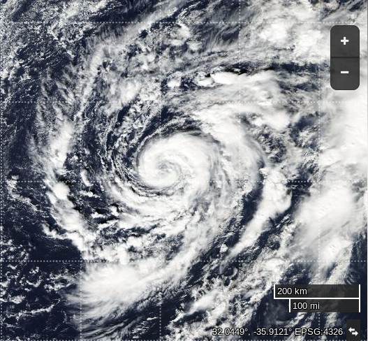
and here's an image of Alex courtesy of NASA's Aqua satellite, at the same scale as our picture of Pali yesterday:

Filed under Climate by
Comments on Subtropical Storm Alex Arrives in the North Atlantic »

January 13, 2016

Reginald Perrin @ 9:51 pm

I have a feeling things may soon become weird

January 14, 2016

Jim Jim @ 10:03 am

Things are gradually getting weirder Reggie.

Slightly to the south of Alex "Disturbance 1" has now turned red on the NHC's map, with:

A 70% chance of cyclone formation in 48 hours.

As Alex continues to head towards Greenland:

the latest NHC bulletin says:

…ALEX CONTINUES TO STRENGTHEN…
…EXPECTED TO AFFECT THE AZORES TONIGHT AND FRIDAY…

SUMMARY OF 500 AM AST…0900 UTC…INFORMATION
———————————————-
LOCATION…30.1N 29.3W
ABOUT 560 MI…905 KM SSW OF THE AZORES
MAXIMUM SUSTAINED WINDS…70 MPH…110 KM/H
PRESENT MOVEMENT…NNE OR 20 DEGREES AT 18 MPH…30 KM/H
MINIMUM CENTRAL PRESSURE…984 MB…29.06 INCHES

Meanwhile even as we speak an even larger storm is also heading toward Greenland:

The swell created by all this frantic activity in the North Atlantic is currently forecast by Magic Seaweed to arrive at my local beachbreak on Sunday:

Jim Jim @ 4:35 pm

In the latest news from the NHC Alex has been upgraded to a category 1 hurricane:

ALEX BECOMES A HURRICANE…
HURRICANE WARNING ISSUED FOR THE AZORES…

SUMMARY OF 1100 AM AST…1500 UTC…INFORMATION
———————————————–
LOCATION…31.5N 28.4W
ABOUT 490 MI…790 KM S OF FAIAL ISLAND IN THE CENTRAL AZORES
MAXIMUM SUSTAINED WINDS…85 MPH…140 KM/H
PRESENT MOVEMENT…NNE OR 20 DEGREES AT 20 MPH…31 KM/H
MINIMUM CENTRAL PRESSURE…981 MB…28.97 INCHES

Here's today's view from on high, courtesy of NASA's Terra satellite:

Jim Jim @ 6:03 pm

In their interim bulletin 4A, issued at 18:00 UTC, the NHC summarise the state of play in the North Atlantic as follows:

ALEX HEADED FOR THE AZORES…

LOCATION…32.6N 28.0W
ABOUT 415 MI…670 KM S OF FAIAL ISLAND IN THE CENTRAL AZORES
MAXIMUM SUSTAINED WINDS…85 MPH…140 KM/H

A Hurricane Warning is in effect for…
* Faial, Pico, Sao Jorge, Graciosa, and Terceira in the central
Azores

A Tropical Storm Warning is in effect for…
* Sao Miguel and Santa Maria in the eastern Azores

Their "discussion" goes on to say that:

On the forecast track, the center of Alex will move near or over portions of the Azores Friday morning.

Maximum sustained winds are near 85 mph (140 km/h) with higher gusts. Little change in strength is forecast through Friday.

Hurricane force winds extend outward up to 25 miles (35 km) from the center and tropical storm force winds extend outward up to 150 miles (240 km).

The estimated minimum central pressure is 981 mb (28.97 inches).

Alex is expected to produce total rain accumulations of 3 to 5 inches over the Azores through Friday, with possible isolated maximum amounts of 7 inches. These rains could produce life-threatening flash floods and mud slides.

A dangerous storm surge is expected to produce significant coastal flooding near and to the east of the center of Alex. Near the coast, the surge will be accompanied by large and destructive waves.

Reginald Perrin @ 7:56 pm

Remember all the #missing_heat?

Reggie believes it is coming out of the oceans and 2016 will not be kind to what is left of the #arctic_ice

2012 will be repeated #deja_vu_all_over_again

Jim Jim @ 9:02 pm

I'm inclined to agree with you about all that heat Reggie. See e.g.:

http://GreatWhiteCon.info/2016/01/new-year-2016-arctic-meltdown-update/#comment-213161

et seq.

Jim Jim @ 9:07 pm

The latest NHC discussion about Hurricane Alex states that

Alex is expected to maintain hurricane strength while passing near or over the Azores. In 24 hours or so, the global models show a distinct warm front over the northeast portion of the circulation. This suggests extratropical transition, and the official forecast reflects this. Later in the forecast period, the global models show the system merging with another extratropical cyclone over the northern Atlantic.

FORECAST POSITIONS AND MAX WINDS

INIT 14/2100Z 33.6N 27.8W 75 KT 85 MPH
12H 15/0600Z 36.4N 27.5W 75 KT 85 MPH
24H 15/1800Z 41.8N 27.9W 70 KT 80 MPH…POST-TROP/EXTRATROP
36H 16/0600Z 49.5N 29.7W 65 KT 75 MPH…POST-TROP/EXTRATROP
48H 16/1800Z 56.5N 34.0W 60 KT 70 MPH…POST-TROP/EXTRATROP
72H 17/1800Z…MERGED WITH ANOTHER EXTRATROPICAL CYCLONE

For much more on that topic see also:

Is the Son of Storm Frank Heading for the Arctic?

Expect another interim bulletin from the NHC in 3 hours time.

January 15, 2016

Jim Jim @ 12:05 am

This evening's interim bulletin from the NHC still forecasts hurricane force winds and an associated storm surge for the Azores on Friday:

ALEX MOVING NORTHWARD TOWARD THE AZORES…
HURRICANE CONDITIONS EXPECTED OVER PORTIONS OF THE AZORES BY EARLY FRIDAY

SUMMARY OF 800 PM AST…0000 UTC…INFORMATION
———————————————-
LOCATION…33.9N 27.8W
ABOUT 330 MI…530 KM S OF FAIAL ISLAND IN THE CENTRAL AZORES
MAXIMUM SUSTAINED WINDS…85 MPH…140 KM/H
PRESENT MOVEMENT…N OR 5 DEGREES AT 22 MPH…35 KM/H
MINIMUM CENTRAL PRESSURE…981 MB…28.97 INCHES

Leave a Comment

Fields marked by an asterisk (*) are required.

Subscribe without commenting