September 4, 2011

Surfing Professionals at Long Beach Look Forward to Katia's Swell

Back in January the Association of Surfing Professionals announced their controversial decision to hold:

The first-ever ASP World Tour stop on the East Coast of the United States,  set to take place on Long Island’s Long Beach from September 4-15. The event will offer a $1 million dollar prize purse to competitors, an amount unprecedented in professional surfing.

According to the initial press release:

September 4-15 is one of the most consistent time periods for sizeable surf in the region. In addition, independent local feedback supports these findings, with September typically averaging 3+ hurricane swells, typically with at least one 3-4 day swell.

As things have turned out Quiksilver, the commercial sponsors of the event, have received rather more in the way of  hurricane swells than they initially bargained for. In a news release last week in the wake of Hurricane Irene they announced that:

Quiksilver is working closely with the City of Long Beach to preserve the heart of the ASP World Tour surf contest scheduled to start on Sunday, September 4 in light of the impact of Hurricane Irene and concerns for the Long Beach community, which suffered significant damage from the storm.

The situation has been changing daily, and we recognize that City resources are focused on hurricane restoration and clean up as first priority.  In that context, we have been informed by the City that the festival and music components of the event are no longer achievable.

The Quiksilver Pro NY is first and foremost about the surf contest and Long Beach has an incredible surfing tradition and spirit.  We are committed to holding the ASP tour event at Long Beach so that together we can promote the sport by bringing together the best surfers in the world to this terrific community.

Surf forecasters across the globe are currently examining their charts closely and announcing their predictions for the effect Hurricane Katia will have on the swell at Long Beach over the contest period. According to Surfline, the World Championship Tour's official forecaster:

The forecast track and strength of Katia is favorable to send surf to Long Island next week. We will see SE swell forerunners to show during the second half of the day on Sunday. Pulsy SE swell is expected to come up on Monday, filling in a little more into Tuesday. With Katia expected to strengthen we do anticipate medium to solid SE swell for mid/late next week. This outlook is dependent on the eventual track and strength of Katia over the next several days.

According to UK surf website MagicSeaweed:

The latest model numbers for swell are remarkably consistent from Florida right up to the Quik contest site at Long Beach, we’re in the 6-10ft@14 seconds range at peak and this is taken from our normal swell model which tends to run cool on these small, intense storms. Additionally the relatively slow moving storm is going to generate a more slowly building swell that looks like it could plausibly give almost a full week of swell against the short lived ‘surfing in the storm’ style swell that Hurricane Irene delivered.

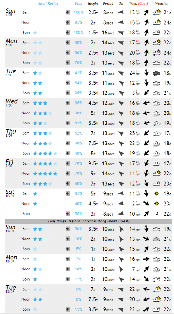
Here's their current surf forecast for the New York area for the next 10 days or so:

MagicSeaweed surf forecast for Long Beach on Sunday September 4th 2011

MagicSeaweed surf forecast for Long Beach on Sunday September 4th 2011

For comparison purposes you might wish to read our discussion of the MagicSeaweed surf forecast for New York a week ago. If you would also like to watch what the best surfers in the world can achieve in whatever swell Katia ultimately delivers to New York over the next ten days then the contest starts today, and you can watch the event live courtesy of Quiksilver's web site.

Filed under Disasters by
September 3, 2011

Tropical Storm Lee Drenches Louisiana

The Gulf of Mexico "Area 1" we mentioned on Thursday has now developed into the thirteenth named Northern Hemisphere Tropical Cyclone. According to the National Hurricane Center's latest public advisory bulletin about Tropical Storm Lee:

TROPICAL STORM LEE STRENGTHENING. HEAVY RAINS OCCURRING OVER SOUTHERN LOUISIANA WITH TROPICAL STORM CONDITIONS CONTINUING ALONG THE COAST. LOCATION ABOUT 15 MILES SSE OF INTRACOASTAL CITY LOUISIANA. MAXIMUM SUSTAINED WINDS 60 MPH.

TROPICAL STORM LEE IS EXPECTED TO PRODUCE TOTAL RAIN ACCUMULATIONS OF 10 TO 15 INCHES OVER SOUTHERN LOUISIANA, SOUTHERN MISSISSIPPI, AND SOUTHERN ALABAMA THROUGH SUNDAY NIGHT, WITH
POSSIBLE ISOLATED MAXIMUM AMOUNTS OF 20 INCHES. THESE RAINS ARE EXPECTED TO CAUSE EXTENSIVE FLOODING. RAINFALL AMOUNTS OF 4 TO 8 INCHES WILL BE POSSIBLE OVER THE FLORIDA PANHANDLE THROUGH SUNDAY NIGHT.

A STORM SURGE WILL RAISE WATER LEVELS BY AS MUCH AS 3 TO 5 FEET ABOVE GROUND LEVEL ALONG THE LOUISIANA COAST, AND BY AS MUCH AS 2 TO 4 FEET ABOVE GROUND LEVEL ALONG THE MISSISSIPPI AND
ALABAMA COASTS INCLUDING MOBILE BAY.

In view of this prognosis we have added the Gulf states in Lee's vicinity to our continuing power outage survey. Currently 16,495 customers are reported as being without electric power in the region.

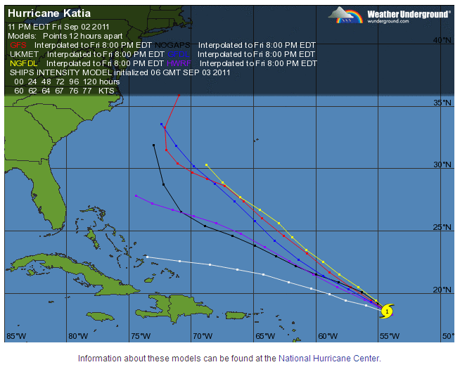
In the meantime Hurricane Katia seems unlikely to affect New Orleans this time around, although Lee most certainly will. Katia (the Russian diminutive of Yekaterina) would have been called Katrina in previous storm naming cycles, but has been renamed "for obvious reasons of sensitivity".  The Weather Underground map of predictions of Katia's  track over the next few days according to a variety of different computerised models show her possibly going to a number of different places, none of which are currently in the Gulf of Mexico:

Weather Underground Computer Model Hurricane Forecasts for Hurricane Katia on Saturday September 3rd 2011

Computer Model Hurricane Forecasts for Hurricane Katia on Saturday September 3rd 2011

Filed under Projects by

September 1, 2011

Hurricane Katia Heads West. Typhoon Nanmadol Kills 29 in the Far East.

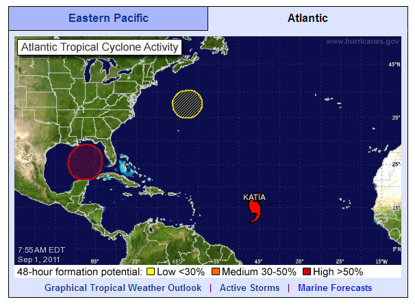
Here's the latest NHC overview of  North Atlantic tropical cyclone activity. As predicted Katia is now officially a category 1 hurricane, and is still forecast to become category 3 over the coming Labor Day weekend.

North Atlantic tropical cyclone activity at 7:55 AM on Thursday September 1st 2011

North Atlantic tropical cyclone activity at 7:55 AM on Thursday September 1st 2011

According to the NHC's latest public advisory bulletin:

KATIA IS MOVING TOWARD THE WEST NEAR 20 MPH. A GENERAL MOTION TOWARD THE WEST-NORTHWEST AND A DECREASE IN FORWARD SPEED ARE EXPECTED DURING THE NEXT COUPLE OF DAYS.

MAXIMUM SUSTAINED WINDS ARE NEAR 75 MPH, WITH HIGHER GUSTS. SOME STRENGTHENING IS FORECAST DURING THE NEXT 48 HOURS AND KATIA COULD BECOME A MAJOR HURRICANE BY THE WEEKEND.

HURRICANE FORCE WINDS EXTEND OUTWARD UP TO 25 MILES FROM THE CENTER AND TROPICAL STORM FORCE WINDS EXTEND OUTWARD UP TO 125 MILES.

In addition there is a new "Area 1", color coded red, in the Gulf of Mexico. According to the NHC once more:

A TROUGH OF LOW PRESSURE LOCATED OVER THE CENTRAL GULF OF MEXICO IS PRODUCING A LARGE AREA OF CLOUDINESS AND THUNDERSTORMS AND GUSTY WINDS MAINLY ON ITS EAST SIDE. UPPER-LEVEL WINDS ARE CURRENTLY UNFAVORABLE FOR DEVELOPMENT. HOWEVER CONDITIONS ARE FORECAST TO BECOME MORE CONDUCIVE LATER TODAYAND. THIS SYSTEM HAS A HIGH CHANCE, 70 PERCENT, OF BECOMING A TROPICAL CYCLONE DURING THE NEXT 48 HOURS AS IT MOVES SLOWLY NORTHWESTWARD. INTERESTS ALONG THE ENTIRE NORTHERN GULF OF MEXICO COAST SHOULD MONITOR THE PROGRESS OF THIS DISTURBANCE.

Meanwhile in the Far East the National Disaster Risk Reduction and Management Council in the Philippines said in its latest bulletin on the effects of  Typhoon Nanmadol that:

  • The total number of population affected is 84,114 families (348,473 people).
  • The total number of population served inside 18 evacuation centers is 725 families / 3,169 persons and outside those centers is 10,590 families / 41,437 persons.
  • Casualties include 29 dead, 37 injured and 5 still missing.

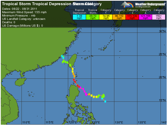
Here's the record of how Nanmadol came to produce those statistics, courtesy of Weather Underground:

Weather Underground track of Typhoon Nanmadol on Wednesday August 31st 2011

Track of Typhoon Nanmadol on Wednesday August 31st 2011

As you can see, according to Weather Underground:

US damage: $0 million

However according to the NDRRMC:

Overall cost of assistance so far amounts to PhP 10,720,504.50

The initial cost of damages to infrastructure (roads and bridges, schools) and agriculture (crops, HVCC, livestock, fisheries, and Agri-infra) amounted to PhP 1,409,464,973.39

This morning the English language version of the People's Daily Online in China reports that:

Typhoon Nanmadol turned into a tropical storm over the West Pacific and strengthened into an ultra strong typhoon landing at Jinjiang city of Fujian province at 2:20 a.m. on Aug. 31.

More than 560,000 residents of Fujian province were victims of rainstorms and building collapses caused by the landing of Typhoon Nanmadol.

According to the data from the Office of Flood Control in Fujian province, more than 207,000 victims were transported out and no casualties have occurred as of 5 p.m. on Aug. 31.

Filed under Disasters by
August 30, 2011

Katia Forecast to Become a Major Hurricane by Sunday

Yesterday I became involved in a debate over on the Economist website about "hurricane hype". The article is entitled "The Storm-clouds clear" and was based on the premise that Hurricane Irene didn't turn out to be as bad as predicted. I was definitely on the side of those expressing the view that you should:

Never underestimate a hurricane.

Some other points of view included:

I wonder if people will take future hurricane warnings, such as mandatory evacuations, as seriously in the future. Many people feel like at least the media, if not the politicians as well, "cried wolf."

I believe that producers and editors of TV & print media are exquisitely sensitive to what catches the attention of their audience, both actual and potential. They adjust content and coverage to maximize views and revenues.

Using "opportunity cost" analysis, the government should do (almost) nothing to prepare for hurricanes. The idea that because hurricanes are hard to predict, so let's just evacuate every coastal city, is nonsense. Government needs to let the hurricanes do what they will, and then quickly fix any damage that might have been done. The cost of all the preparations far exceed any damage Irene did or might have done.

The models that predict a hurricane's path and strength are tweaked by the insurance companies, or their hired experts, to err strongly on the more dangerous side. Then these models are used to justify increases in the price of hurricane insurance.

This was a practice run, BUT WHAT ARE THE RULING CLASS PREPARING US FOR?

Hype on top of hype? Whilst the debate raged Connecticut Light & Power were reporting that:

At the peak, the storm left more than 622,000 CL&P customers without power. This sets a record, surpassing the 477,000 CL&P customers who lost power from Hurricane Gloria in 1985.

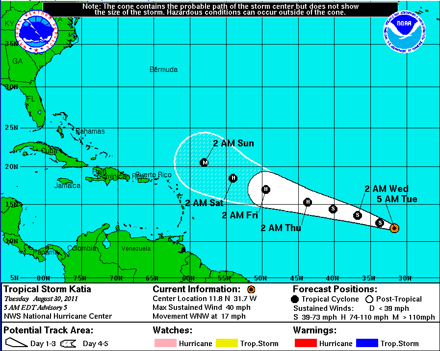
Please forgive me for adding yet more wind to this media storm, but another set of storm clouds are now gathering on the distant horizon. As I suggested yesterday "Area 1" has now morphed into "Tropical Storm Katia". Here are the NHC's current projections:

5 day forecast for Tropical Storm Katia at 5 AM EDT on Tuesday August 30th 2011

5 day forecast for Tropical Storm Katia at 5 AM EDT on Tuesday August 30th 2011

If you look closely you can see that "Tropical Storm" Katia is currently heading in the direction of the eastern seaboard of the United States on a track slightly to the north of Irene's, and that she is forecast to become a major hurricane by 2 AM on Sunday morning. Are the ruling class preparing us for something? Are the NHC's computer models tweaked by the insurance companies' hired experts. Is the current forecast in any way predictive of what will ultimately happen? Does anyone want to place their bets now?

Filed under Disasters by
August 29, 2011

What Would Happen if Wall Street Were Under Water?

In their most recent public advisory bulletin at 11:00 PM EDT last night the National Hurricane Centre said that:

IRENE BECOMES POST-TROPICAL NEAR THE U.S./CANADIAN BORDER. THE TROPICAL STORM WARNING FOR THE EAST COAST OF THE UNITED STATES HAS BEEN DISCONTINUED.

ELEVATED WATER LEVELS ALONG THE COAST OF NEW ENGLAND WILL SUBSIDE OVERNIGHT AND ON MONDAY.

HEAVY RAINS ARE DIMINISHING OVER NORTHERN NEW ENGLAND. ANY ADDITIONAL ACCUMULATIONS SHOULD AMOUNT TO LESS THAN ONE INCH.

WINDS OF TROPICAL STORM FORCE, ESPECIALLY IN GUSTS, COULD STILL OCCUR ACROSS PORTIONS OF EASTERN NEW ENGLAND, NEW
BRUNSWICK AND NOVA SCOTIA OVERNIGHT. SIGNIFICANTLY HIGHER WINDSPEEDS ARE LIKELY OVER AREAS OF ELEVATED TERRAIN IN NORTHERN NEW ENGLAND AND EASTERN CANADA.

The "mandatory" evacuation of low lying areas of New York City has now been lifted. Here's how the crisis map looks this morning:

New York City evacuation map at 2:45 AM EDT on August 29th 2011

New York City evacuation map at 2:45 AM EDT on August 29th 2011

More on What Would Happen if Wall Street Were Under Water?

Filed under Disasters by
August 28, 2011

Irene Weakens to Tropical Storm Force, but Millions of Lights are Still Out

In their interim 9 AM EDT public advisory bulletin the National Hurricane Centre said that:

CENTER OF IRENE MOVES OVER NEW YORK CITY

REPORTS FROM AN AIR FORCE HURRICANE HUNTER AIRCRAFT AND NATIONAL WEATHER SERVICE DOPPLER RADAR INDICATE THAT THE CENTER OF IRENE MOVED OVER NEW YORK CITY AROUND 900 AM EDT, 1300 UTC. IRENE HAS WEAKENED TO A TROPICAL STORM AND THE ESTIMATED INTENSITY AT LANDFALL WAS 65 MPH

By 11 AM the NHC were reporting that:

MAXIMUM SUSTAINED WINDS ARE NEAR 60 MPH WITH HIGHER GUSTS. IRENE IS FORECAST TO WEAKEN AND BECOME A POST-TROPICAL CYCLONE BY TONIGHT.

TROPICAL STORM FORCE WINDS EXTEND OUTWARD UP TO 320 MILES FROM THE CENTER. ESTIMATED MINIMUM CENTRAL PRESSURE IS 966 MB…28.53 INCHES. CENTRAL PARK IN NEW YORK CITY REPORTED 966.5 MB…28.54 AS THE CENTER PASSED THIS MORNING.

The danger is now dissipating over southern New England, but millions of people are still without power, and a long wait to have it restored will now ensue for many of them. A hasty trawl around the utilities websites reveals the following statistics:

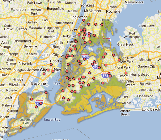
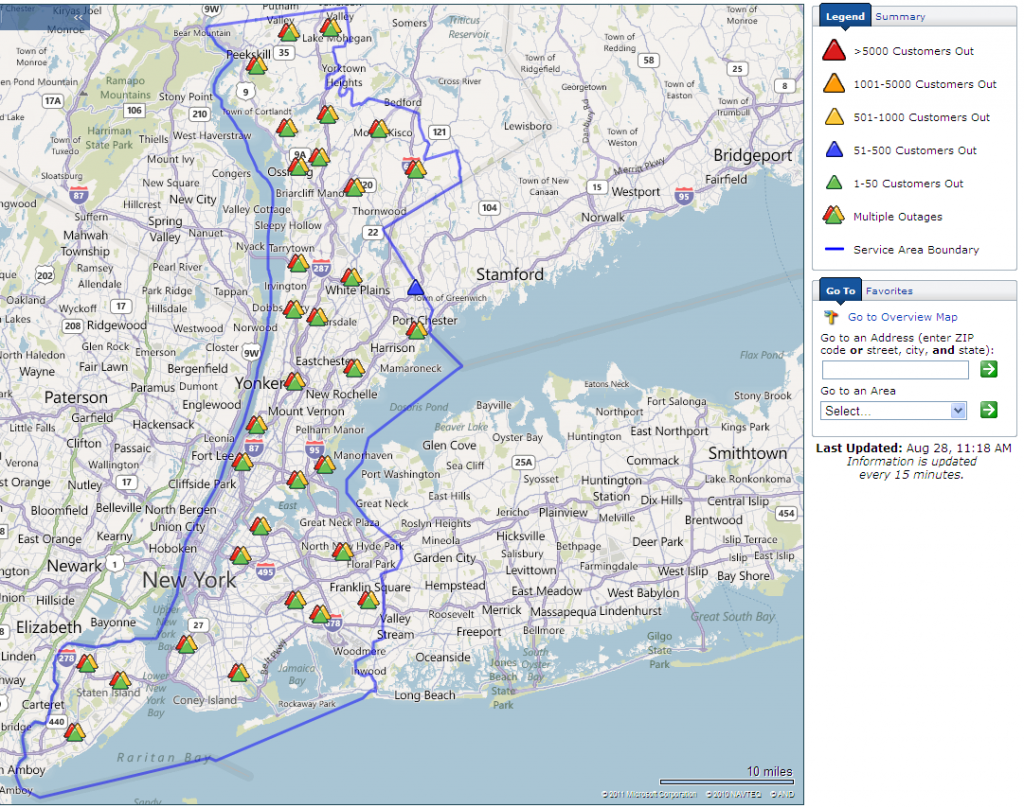
At 7:00 AM today Con Edison reported that:

72,000 customers in New York City and Westchester County have lost electrical service because of severe winds resulting from Hurricane Irene.  As the weather system continues to move toward New York, the number of affected customers is expected to grow.

Con Edison New York City Power Outage Map at 11:29 AM on Sunday August 28th 2011

New York City Power Outage Map at 11:29 AM on Sunday August 28th 2011

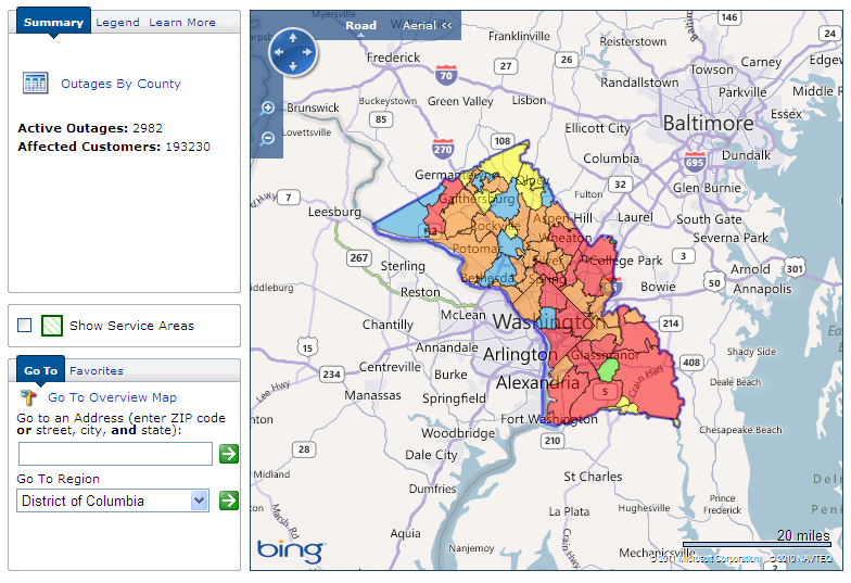
At 7:30 AM today Pepco reported that in Washington:

Damage to the electrical infrastructure has been extensive up and down the East Coast. As of 7:30 a.m., approximately 194,000 Pepco customers were without power. This is reduced from 220,000 customers without power earlier during the storm.

Pepco Washington D.C. Power Outage Map at 11:29 AM on Sunday August 28th 2011

Washington D.C. Power Outage Map at 11:29 AM on Sunday August 28th 2011

At 9:00 AM today Progress Energy reported that in North Carolina:

Progress Energy has restored service to thousands of customers who lost power in the wake of Hurricane Irene, and more than 1,200 utility workers and tree crews – now four times the normal complement – are taking aim on approximately 176,000 customers still without power as of 9 a.m.

The highest number of outages at any one time was estimated at approximately 280,000 around 2 p.m. Saturday. The actual number of customers who experienced outages at one time or another during the storm was significantly higher. In fact, since noon on Friday, Aug. 26, as the first bands of Hurricane Irene reached the Carolinas, more than 440,000 customers have lost power for varying periods.

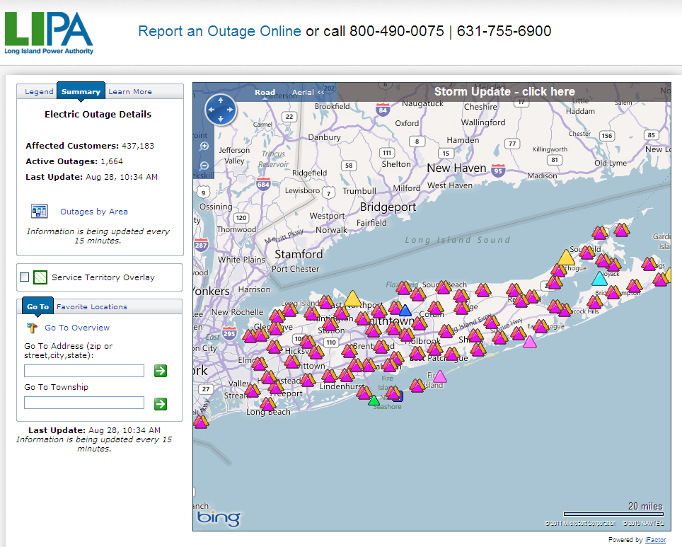
At 10:34 AM today the Long Island Power Authority outage map showed "437,183 affected customers".

Long Island Power Authority Outage Map at 10:34 AM on Sunday August 28th 2011

Long Island Power Outage Map at 10:34 AM on Sunday August 28th 2011

At 10:30 AM today Dominion reported that in Virginia and North Carolina:

Dominion crews in Virginia and North Carolina are assessing damage and working with local emergency personnel today to return electrical service to 1.2 million customers, focusing first on public health and safety facilities. The Hurricane Irene restoration effort is the company's second largest behind only Hurricane Isabel.

and also released this video:

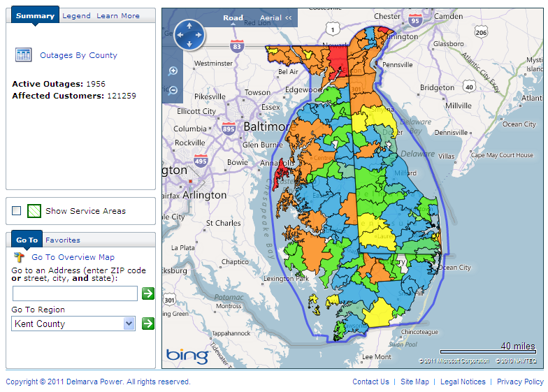
At 10:51 AM today the Delmarva Power outage map showed "121,253 affected customers" in Delaware and Maryland.

Delmarva Power Outage Map for Maryland/Delaware at 10:51 AM on Sunday August 28th 2011

Maryland/Delaware Power Outage Map at 10:51 AM on Sunday August 28th 2011

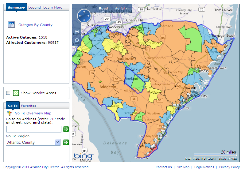
At 11:30 AM today the Atlantic City Electric outage map showed "90,987 affected customers" in southern New Jersey.

Atlantic City Electric power outage map for southern New Jersey at 11:30 AM on Sunday August 28th 2011

Southern New Jersey power outage map at 11:30 AM on Sunday August 28th 2011

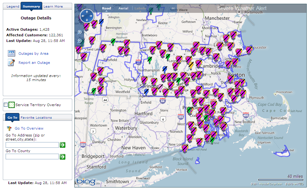
At 11:58 AM today the National Grid outage map showed "122,361 affected customers" in Massachusetts.

National Grid power outage map for Massachusetts at 11:58 AM on Sunday August 28th 2011

Massachusetts power outage map at 11:58 AM on Sunday August 28th 2011

During my initial "straw poll" some of the utilities websites I tried appeared not to be functioning properly, perhaps suffering under the weight of requests. Those that did respond reveal a total of 2,413,784 customers without power. The total number of people without power along the eastern seaboard of the United States of America this afternoon is obviously very much larger than that.

A proportion of those outages may in part be due to an "unusual event" which occurred at Constellation Energy's Calvert Cliffs nuclear power plant in Maryland. According to Constellation's press release earlier today

The Calvert Cliffs Nuclear Plant Unit 1 operated by Constellation Energy Nuclear Group (CENG) automatically went off line late Saturday after a piece of aluminum siding propelled by wind gusts hit the nuclear facility's main transformer. Calvert Cliffs Unit 2 remains at 100 percent power.

All safety systems operated as designed when Unit 1 automatically went off line. As required by federal regulations, CENG declared an Unusual Event (UE) at 11:02 p.m. Saturday; a UE is the lowest of four emergency classifications established by the U.S. Nuclear Regulatory Commission. The UE presents no threat to public health or safety.

Currently Associated Press is reporting that:

Hurricane Irene had led to the deaths of 14 people in six states as of Sunday morning.

Filed under Disasters by
Centre of Irene Nearing New York City – Oyster Creek Reactor Shut Down

In their 8 AM EDT public advisory bulletin the National Hurricane Centre say that the:

CENTER OF IRENE NEARING NEW YORK CITY

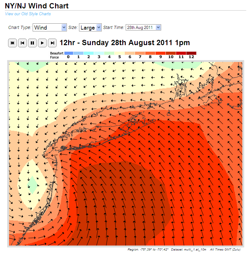
whilst the warnings they issued at 2 AM remain much the same. The models used by surf forecasting website MagicSeaweed suggest that the eye of the storm is currently passing almost directly over New York City, accompanied by strong onshore winds:

Wind forecast for New York City for 13:00 UTC on Sunday August 28th 2011

Wind forecast for New York City for 13:00 UTC on Sunday August 28th 2011

Those winds look set to swing strong offshore fairly soon, and those same winds and waves have only recently passed Exelon Corporation's Oyster Creek nuclear reactor. In anticipation of these events Exelon issued a press release last night stating that:

Operators at Oyster Creek Generating Station manually took the station’s generator off line at about 5 p.m. tonight.

Operators began a controlled shut-down of the reactor at 8 a.m. today due to the expected hurricane force winds from Hurricane Irene.

By procedure, Oyster Creek is required to shut down if sustained winds reach a certain level during a hurricane.  For this reason operators proactively, deliberately and slowly began the shutdown in anticipation of the storm’s arrival to ensure the plant was in a safe condition.

“Although we cannot predict with certainty whether we will see those wind speeds on the plant site, based on current weather projections and because of Oyster Creek’s proximity to Barnegat Bay and the Atlantic Ocean, it is prudent to safely shut down the plant in advance,” said Site Vice President Michael Massaro.

Whilst the Exelon website does mention that:

Oyster Creek began operating in December 1969 as the first large-scale commercial nuclear power plant in the United States.

for some reason neither their website overview of the reactor or that press release mentions that the reactor in question uses a GE Mark I containment vessel, the same type used at the Fukushima nuclear plant in Japan.

For some reason the press release issued by Progress Energy yesterday morning also neglected to mention that their Brunswick nuclear plant also uses a GE Mark I containment vessel.

Filed under Disasters by

Storm Surge and Tornados From Hurricane Irene Threaten New York

This morning's first public advisory bulletin from the National Hurricane Center places the eye of Hurricane Irene "About 195 miles south-southwest of New York City" and warns that:

AN EXTREMELY DANGEROUS STORM SURGE WILL RAISE WATERLEVELS BY AS MUCH AS 4 TO 8 FEET ABOVE GROUND LEVEL WITHIN THE HURRICANE WARNING AREA FROM THE NORTH CAROLINA/VIRGINIA BORDER NORTHWARD TO CAPE COD INCLUDING SOUTHERN PORTIONS OF THE CHESAPEAKE BAY AND ITS TRIBUTARIES. NEAR THE COAST THE SURGE WILL BE ACCOMPANIED BY LARGE DESTRUCTIVE AND LIFE-THREATENING WAVES. HIGHER THAN NORMAL ASTRONOMICAL TIDES ARE OCCURRING THIS WEEKEND. COASTAL AND RIVER FLOODING WILL BE HIGHEST IN AREAS WHERE THE PEAK SURGE OCCURS AROUND THE TIME OF HIGH TIDE. STORM TIDE AND SURGE VALUES ARE VERY LOCATION-SPECIFIC AND USERS ARE URGED TO CONSULT PRODUCTS ISSUED BY THEIR LOCAL NATIONAL WEATHER SERVICE OFFICES.

IRENE IS EXPECTED TO PRODUCE RAINFALL ACCUMULATIONS OF 6 TO 12 INCHES WITH ISOLATED MAXIMUM AMOUNTS OF 20 INCHES FROM EASTERN NORTH CAROLINA NORTHWARD THROUGH THE MID-ATLANTIC STATES INTO EASTERN NEW YORK AND INTERIOR NEW ENGLAND. THESE RAINS COMBINED WITH HEAVY RAINS OVER THE PAST FEW WEEKS COULD CAUSE WIDESPREAD FLOODING,LIFE-THREATENING FLASH FLOODS AND SIGNIFICANT UPROOTING OF TREES DUE TO RAIN-SOFTENED GROUNDS.

ISOLATED TORNADOES ARE POSSIBLE OVER SOUTHERN DELAWARE, EASTERN NEW JERSEY, SOUTHEASTERN NEW YORK AND EXTREME SOUTHERN NEW ENGLAND THROUGH THIS MORNING.

WINDS AFFECTING THE UPPER FLOORS OF HIGH-RISE BUILDINGS WILL BE SIGNIFICANTLY STRONGER THAN THOSE NEAR GROUND LEVEL.

According to The Independent newspaper:

Mandatory evacuations have been ordered for 370,000 New Yorkers who live mostly in low-lying areas. The unprecedented orders, which affect New Yorkers from Manhattan and out to the beaches of Brooklyn and Queens, dealt the congested metropolis a formidable logistical challenge that raised more questions than it resolved.

Some questioned where all the people in New York's flood-prone areas were supposed to go and, more pointedly, how they were going to get there since many do not own a car.

According to New York Mayor, Michael Bloomberg, he was confident people would get out of the storm's way:

We do not have the manpower to go door-to-door and drag people out of their homes," he said. "Nobody's going to get fined. Nobody's going to go to jail. But if you don't follow this, people might die.

However Texas meteorologist John Nielsen-Gammon didn't sound as sure as Mayor Bloomberg about that:

It's possible to evacuate without going very far. The big wild card for New York is the fact that nobody there is used to a hurricane and can't rely on common sense or past experience as a guide. And what we learned from evacuations in Houston is that people rely on their friends and their own experience as much as, or more than, they rely on public officials.

Should any of your friends ask you whether staying around to watch is a good idea, I suggest that you recommend that they listen carefully to Michael Bloomberg and if at all possible comply with his suggestions. This is what hurricanes can do:

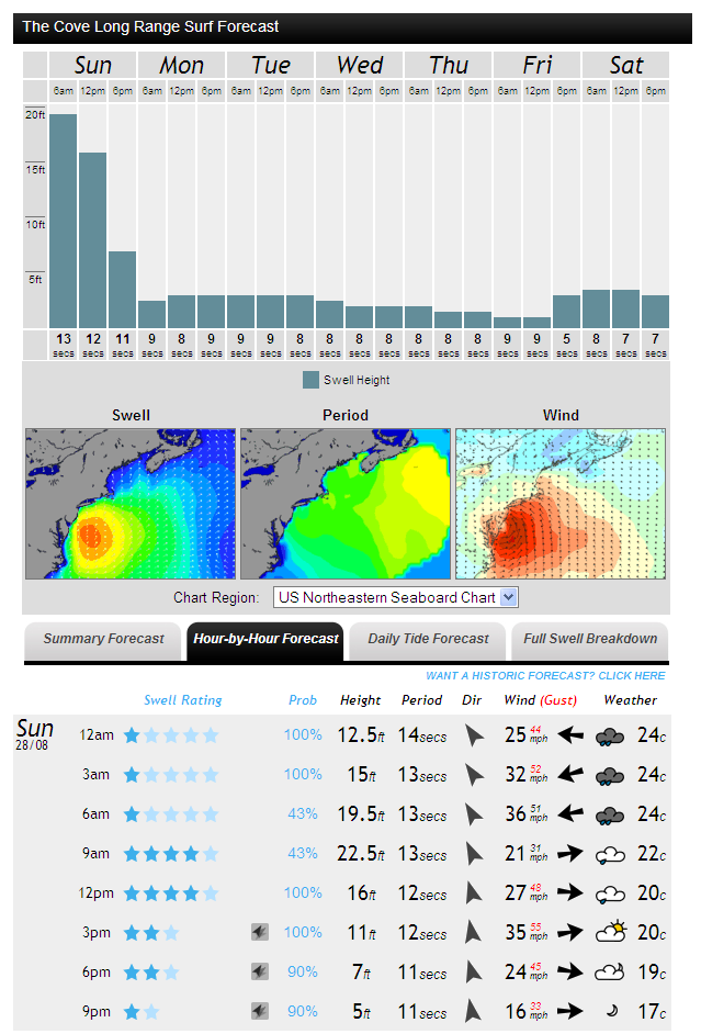
and here is the surf forecast for New York City for today, courtesy of MagicSeaweed:

MagicSeaweed surf forecast for The Cove on Sunday August 28th 2011

MagicSeaweed surf forecast for The Cove on Sunday August 28th 2011

Finally, here is AP's most recent video on the current emergency:

Filed under Disasters by

August 27, 2011

Electric Power Outages Spread North in Irene's Wake

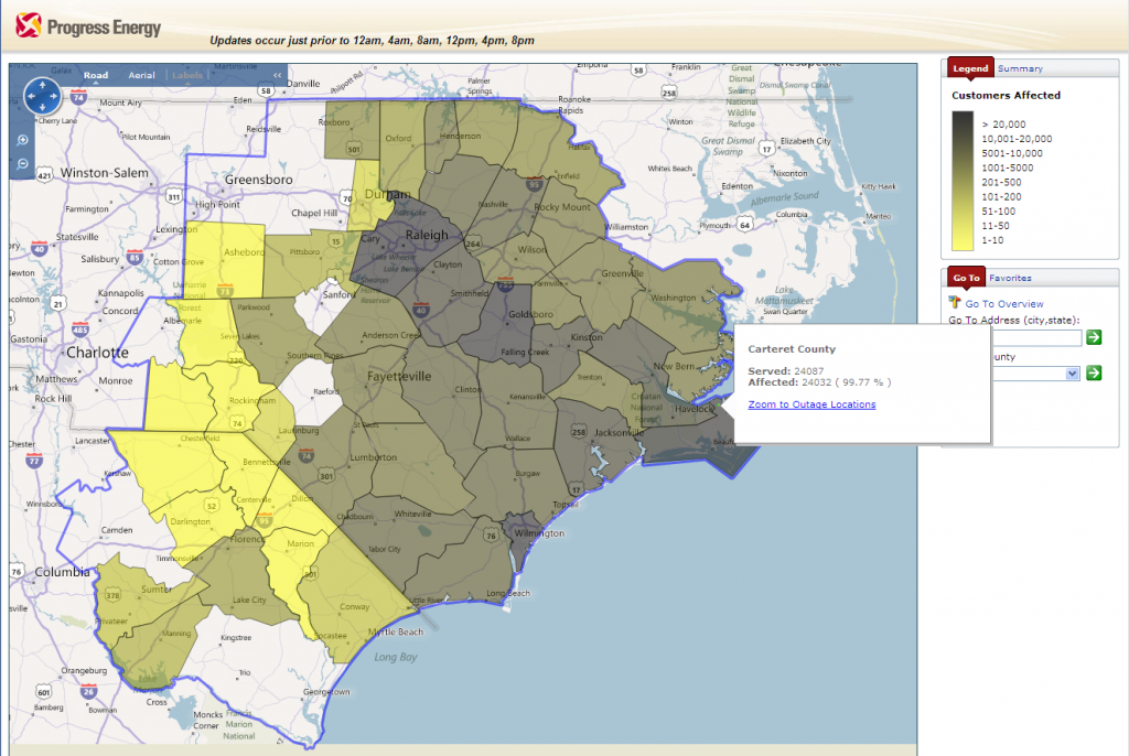
As Hurricane Irene moves at 13 miles per hour north north east along the eastern seaboard of the Unites States massive power outages are following in its wake. Here's how North Carolina looks at 1:30 PM EDT:

Progress Energy North Carolina Power Outage Map at 13:00 on Saturday August 27th 2011

North Carolina Power Outage Map at 13:00 on Saturday August 27th 2011

According to Progress Energy's website Pitt County now has 100.5 % power outage (sic), Beaufort County has 100 %, and the rather more populous Carteret County is up to 99.77 % without mains electricity.

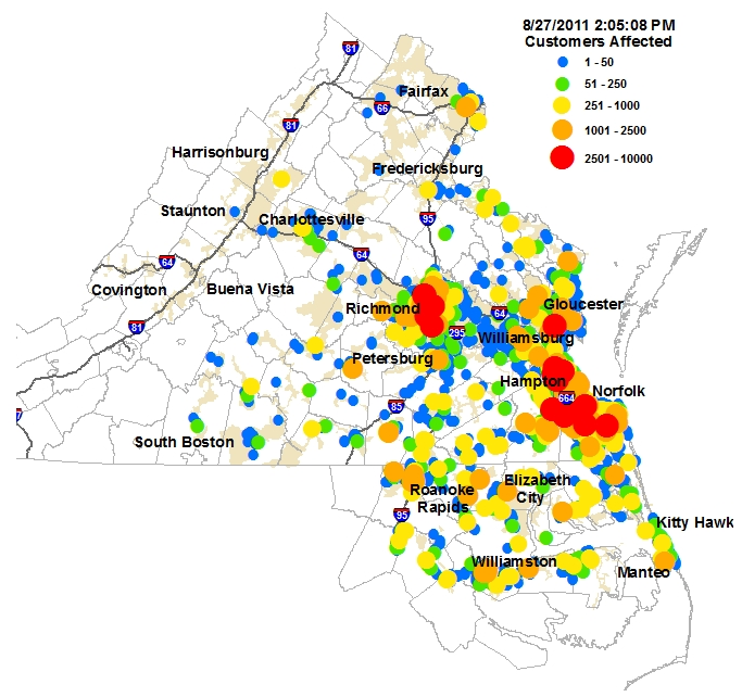
Further north in Virginia Dominion Electric's interactive power outage map now displays a large number of brightly coloured spots:

Dominion Electric Virginia Power Outage Map at 14:00 on Saturday August 27th 2011

Virginia Power Outage Map at 14:00 on Saturday August 27th 2011

However that doesn't make it easy to get an overview of what's happening across the state. Dominion also provide a summary table which currently reveals that across their patch in Virginia and North Carolina:

Customers Assigned: 2,442,740 Customers Out: 369,357

which I make just over 15%.

Dominion haven't issued any press releases as yet, but they have released some videos. This one contains advice on how to get your power back safely if you're fortunate enough to have a generator of your own:

However David Botkins, Dominion's Director of Media Relations, also says in the video that:

We're not going to put our crews in harm's way when the storm is at its absolute peak. That would be reckless and it would be irresponsible, and we take our public safety and the safety of our employees very seriously, so were just not going to do that. But we are going to be out there in the field as soon as the storm passes and we're going to be assessing for damage and we're going to be going about the business of the restoration of power.

I for one will be following their progress in that mission very closely.

Filed under Disasters by

Carolinas Lose Power as Hurricane Irene Hits Land

According to the National Hurricane Center:

The eye of Irene made landfall near Cape Lookout, North Carolina around 7:30 AM EDT

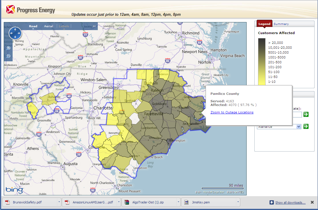
The residents of North Carolina won't need me to remind them of that fact even if they are able to read my words, since large numbers of them are currently without mains electricity.  Here's a snapshot of the online outage map provided to their customers in the Carolinas by Progress Energy:

Progress Energy North Carolina Power Outage Map at 09:00 on Saturday August 27th 2011

North Carolina Power Outage Map at 09:00 on Saturday August 27th 2011

As you can see, the worst affected area is currently Pamlico County, with 97.76% of PE customers without electricity. In numerical terms, rather than percentages, next door neighbour Carteret County is worst affected, with 15710 out of a total of 24087 Progress Energy customers without power.

Online Power Outage Maps

Pepco – Washington D.C.

Long Island Power – Long Island

Con Edison – New York City

First Energy – New Jersey

Atlantic City Electric – New Jersey

Delmarva Power – Maryland

Dominion Electric – Virginia

Progress Energy – North Carolina

Filed under Disasters by