August 29, 2011
What Would Happen if Wall Street Were Under Water?
In their most recent public advisory bulletin at 11:00 PM EDT last night the National Hurricane Centre said that:
IRENE BECOMES POST-TROPICAL NEAR THE U.S./CANADIAN BORDER. THE TROPICAL STORM WARNING FOR THE EAST COAST OF THE UNITED STATES HAS BEEN DISCONTINUED.
ELEVATED WATER LEVELS ALONG THE COAST OF NEW ENGLAND WILL SUBSIDE OVERNIGHT AND ON MONDAY.
HEAVY RAINS ARE DIMINISHING OVER NORTHERN NEW ENGLAND. ANY ADDITIONAL ACCUMULATIONS SHOULD AMOUNT TO LESS THAN ONE INCH.
WINDS OF TROPICAL STORM FORCE, ESPECIALLY IN GUSTS, COULD STILL OCCUR ACROSS PORTIONS OF EASTERN NEW ENGLAND, NEW
BRUNSWICK AND NOVA SCOTIA OVERNIGHT. SIGNIFICANTLY HIGHER WINDSPEEDS ARE LIKELY OVER AREAS OF ELEVATED TERRAIN IN NORTHERN NEW ENGLAND AND EASTERN CANADA.
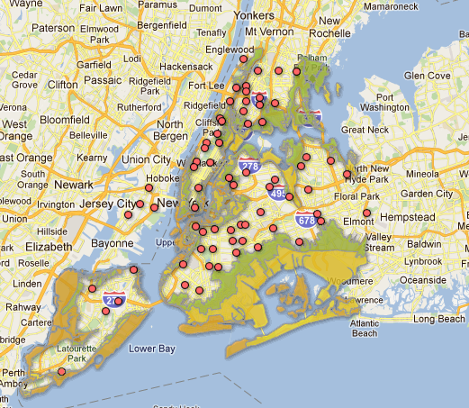
The "mandatory" evacuation of low lying areas of New York City has now been lifted. Here's how the crisis map looks this morning:
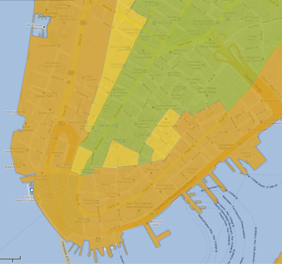
If you zoom in on the financial district this is what you will see:
It's a bit hard to make out because of all the overlays, but the New York Stock Exchange at 11 Wall Street and the Federal Reserve Bank of New York at 33 Liberty Street are both well within the green shaded Zone C, denoting the area subject to "potental flooding from a Category 3-4 hurricane hitting just south of NYC". Ultimately of course, when Irene's eye passed over Central Park yesterday morning she was only a pale shadow of her former self. It wasn't certain that was how things would turn out one or two days ago however. Nonetheless a stock exchange is of course full of people who know everything there is to know about managing risk, and the NYSE is no exception. This morning the market status section of their website tells us that:
NYSE Euronext has determined that its U.S.-based exchanges will be open for business as usual on Monday morning, August 29, 2011, following the passage of Hurricane Irene beyond the New York City metropolitan area. These exchanges are the New York Stock Exchange, NYSE Arca, NYSE Amex, NYSE Arca Options, NYSE Amex Options, and NYSE Liffe U.S.
This decision follows a detailed review with New York City and other officials of the operational readiness of metro-area safety, power, water, and transportation systems, in addition to a readiness assessment of our own trading and data center facilities, along with consultation with staff members, trading professionals, other exchanges, and regulators.
The Opening Bell will ring on the Trading Floor of the New York Stock Exchange at 9:30 a.m. ET on Monday morning.
The New York Fed aren't quite as forthcoming as NYSE, and their news page makes no mention of Irene. However I think in all the circumstances it's safe to assume that they will also be conducting business as usual this morning, even though it seems that they're not welcoming vistors today.
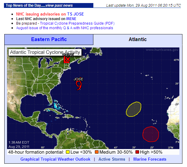
By way of conclusion, here's how the National Hurricane Center's map of the North Atlantic looks this morning:
As you can see, Irene has now been relegated to post-tropical cyclone status, and is no longer giving Wall Street or the Fed much to worry about. However before you go you may want to read what the NHC has to say about the red "Area 1" off the west coast of Africa:
SHOWERS AND THUNDERSTORMS CONTINUE TO BECOME BETTER ORGANIZED IN ASSOCIATION WITH A LOW PRESSURE SYSTEM LOCATED ABOUT 375 MILES SOUTH OF THE SOUTHERN CAPE VERDE ISLANDS AND A TROPICAL DEPRESSION COULD BE FORMING. IF CURRENT TRENDS CONTINUE ADVISORIES WILL LIKELY BE INITIATED LATER THIS MORNING. THIS SYSTEM HAS A HIGH CHANCE, NEAR 100 PERCENT, OF BECOMING A TROPICAL CYCLONE DURING THE NEXT 48 HOURS AS IT MOVES WESTWARD OR WEST-NORTHWESTWARD AT AROUND 15 MPH.
Filed under Disasters by


Comments on What Would Happen if Wall Street Were Under Water? »
In their 5:00 AM EDT update the NHC revealed that "Area 1" had been upgraded to "Tropical Depression Twelve", and they issued their first advisory bulletin: