October 2, 2011
Hurricane Ophelia Batters Bermuda
We're a bit behind on our reporting of the progress of Hurricane Ophelia, because we've been frantically busy here in South West England launching our latest project, which is entitled "Contemporary Art in the Community". More on all that soon, but for now we must firstly apologise to Bermudan resident Tina Barnard who gave us and our other readers some extremely sound advice on how to survive if a hurricane should ever head in the direction of you and your loved ones.
If you're reading this Tina, sorry for not shouting your message more loudly over the last few days, and we sincerely hope that you and your loved ones are safe and well this morning.
A week ago the National Hurricane Centre was reporting that:
OPHELIA DEGENERATES INTO A REMNANT LOW. THIS IS THE LAST ADVISORY.
HAZARDS AFFECTING LAND – NONE
NEXT ADVISORY – THIS IS THE LAST PUBLIC ADVISORY ISSUED BY THE NATIONAL HURRICANE CENTER ON OPHELIA UNLESS REGENERATION OCCURS.
We figured that was that, but as so often happens with hurricane forecasts, we were wrong. The next NHC public advisory bulletin concerning Ophelia was issued at 21:00 UTC on Tuesday September 27th and informed anyone who was reading that:
OPHELIA REGENERATES INTO A TROPICAL DEPRESSION.
HAZARDS AFFECTING LAND – OPHELIA IS EXPECTED TO PRODUCE TOTAL RAINFALL ACCUMULATIONS OF 2 TO 4 INCHES OVER THE NORTHERN LEEWARD ISLANDS.
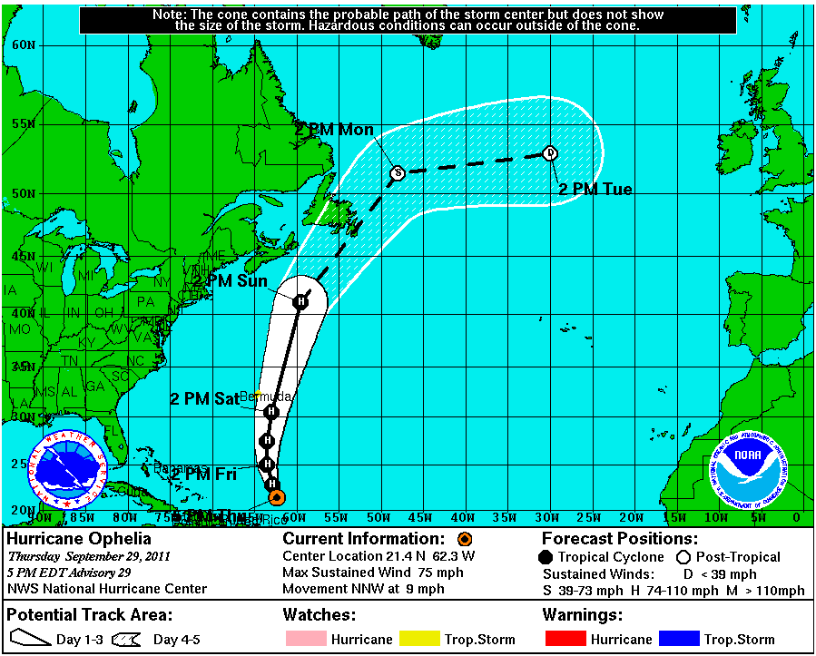
If you take a look at the NHC graphical archive for Hurricane Ophelia you will be able to see what happened thereafter:
By 21:00 on September 29th the NHC was telling us that:
OPHELIA BECOMES THE FOURTH HURRICANE OF THE SEASON. THE BERMUDA WEATHER SERVICE HAS ISSUED A TROPICAL STORM WATCH FOR BERMUDA.
and Bermuda was right on the edge of Ophelia's "potential track" for yesterday evening. As luck would have it Ophelia actually veered slightly to the east of the forecast track after that, rather than slightly to the west. Although Ophelia eventually became a category 4 hurricane, yesterday Bermuda News was able to report that:
Hurricane Ophelia, the fourth hurricane of the 2011 season, is expected to pass 120 nautical miles to the east of Bermuda at approximately 7pm this evening.
Update 1.33pm: In their 12 noon update, the BWS said Ophelia’s closest point of approach to Bermuda will now be 115 nm at 8pm this evening.
Update 3.31pm: The Department of Parks’ Lifeguard Service have erected red, high surf warning signs along the south shore including National Park- South Shore Park and closed Horsehoe Beach.
Given the current weather forecast, the Lifeguard Service expects to resume normal operating hours on Sunday, October 2, [10am-6pm] in addition to removing the high surf warning signs.
Update 7.40pm: At 7.30pm the Bermuda Weather Service cancelled the Tropical Storm Watch
and post a video showing that the surf on Bermuda's south shore was in fact no worse than this:
At the end of the day a very close run thing for Tina and the other inhabitants of Bermuda. The forecast currently shows that Ophelia may eventually provide some large surfable swells here in South West England, so rest assured we will be watching Ophelia rather more closely over the next few days than we were last week.
Filed under Disasters by

Leave a Comment