September 3, 2011
Tropical Storm Lee Drenches Louisiana
The Gulf of Mexico "Area 1" we mentioned on Thursday has now developed into the thirteenth named Northern Hemisphere Tropical Cyclone. According to the National Hurricane Center's latest public advisory bulletin about Tropical Storm Lee:
TROPICAL STORM LEE STRENGTHENING. HEAVY RAINS OCCURRING OVER SOUTHERN LOUISIANA WITH TROPICAL STORM CONDITIONS CONTINUING ALONG THE COAST. LOCATION ABOUT 15 MILES SSE OF INTRACOASTAL CITY LOUISIANA. MAXIMUM SUSTAINED WINDS 60 MPH.
TROPICAL STORM LEE IS EXPECTED TO PRODUCE TOTAL RAIN ACCUMULATIONS OF 10 TO 15 INCHES OVER SOUTHERN LOUISIANA, SOUTHERN MISSISSIPPI, AND SOUTHERN ALABAMA THROUGH SUNDAY NIGHT, WITH
POSSIBLE ISOLATED MAXIMUM AMOUNTS OF 20 INCHES. THESE RAINS ARE EXPECTED TO CAUSE EXTENSIVE FLOODING. RAINFALL AMOUNTS OF 4 TO 8 INCHES WILL BE POSSIBLE OVER THE FLORIDA PANHANDLE THROUGH SUNDAY NIGHT.A STORM SURGE WILL RAISE WATER LEVELS BY AS MUCH AS 3 TO 5 FEET ABOVE GROUND LEVEL ALONG THE LOUISIANA COAST, AND BY AS MUCH AS 2 TO 4 FEET ABOVE GROUND LEVEL ALONG THE MISSISSIPPI AND
ALABAMA COASTS INCLUDING MOBILE BAY.
In view of this prognosis we have added the Gulf states in Lee's vicinity to our continuing power outage survey. Currently 16,495 customers are reported as being without electric power in the region.
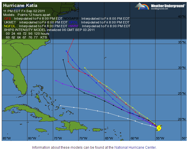
In the meantime Hurricane Katia seems unlikely to affect New Orleans this time around, although Lee most certainly will. Katia (the Russian diminutive of Yekaterina) would have been called Katrina in previous storm naming cycles, but has been renamed "for obvious reasons of sensitivity". The Weather Underground map of predictions of Katia's track over the next few days according to a variety of different computerised models show her possibly going to a number of different places, none of which are currently in the Gulf of Mexico:
Filed under Projects by

Comments on Tropical Storm Lee Drenches Louisiana »
In a report timed at 10:26 AM NOLA.com says that: