November 30, 2012
Typhoon Bopha Has Her Eye on the Philippines
According to the latest advisory bulletin issued by the United States Navy's Joint Typhoon Warning Center (JTWC for short), based at Pearl Harbour in Hawaii, Tropical Storm Bopha has now developed hurricane force winds, and is therefore now classified as a typhoon:
WARNING POSITION: 301200Z — NEAR 4.2N 144.3E
MOVEMENT PAST SIX HOURS – 295 DEGREES AT 10 KTS
POSITION ACCURATE TO WITHIN 060 NM
POSITION BASED ON CENTER LOCATED BY SATELLITE
PRESENT WIND DISTRIBUTION:
MAX SUSTAINED WINDS – 065 KT, GUSTS 080 KT
WIND RADII VALID OVER OPEN WATER ONLY
RADIUS OF 050 KT WINDS – 035 NM NORTHEAST QUADRANT
035 NM SOUTHEAST QUADRANT
035 NM SOUTHWEST QUADRANT
035 NM NORTHWEST QUADRANT
RADIUS OF 034 KT WINDS – 075 NM NORTHEAST QUADRANT
075 NM SOUTHEAST QUADRANT
070 NM SOUTHWEST QUADRANT
070 NM NORTHWEST QUADRANTTYPHOON (TY) 26W (BOPHA) LOCATED APPROXIMATELY 605 NM EAST-SOUTHEAST OF PALAU, HAS TRACKED WEST-NORTHWESTWARD AT 10 KNOTS OVER THE PAST SIX HOURS.
MAXIMUM SIGNIFICANT WAVE HEIGHT AT 301200Z IS 26 FEET.
NEXT WARNINGS AT 302100Z, 010300Z, 010900Z AND 011500Z.
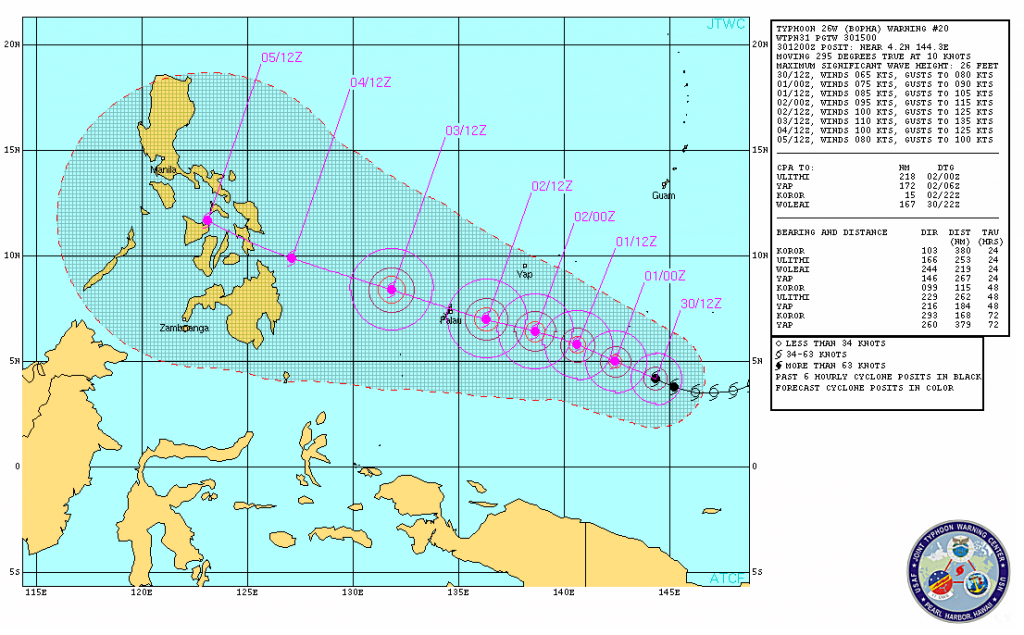
A picture is worth a thousand words and here's the pictorial forecast for Bopha:
As you can see, she is currently aiming straight at the Philippines, and expected to arrive there on the afternoon of December 4th as a category 3 "hurricane". According to AlertNet this will subject the inhabitants of the islands to:
- Storm surge generally 2.7-3.7 metres (9-12 feet) above normal.
- Some structural damage to small residences and utility buildings with a minor amount of curtainwall failures.
- Damage to shrubbery and trees with foliage blown off trees and large trees blown down.
- Mobile homes and poorly constructed signs are destroyed.
- Low-lying escape routes are cut by rising water 3-5 hours before arrival of the centre of the storm.
- Flooding near the coast destroys smaller structures with larger structures damaged by battering from floating debris.
- Terrain continuously lower than 1.5 metres (5 feet) above mean sea level may be flooded inland 13 km (8 miles) or more.
- Evacuation of low-lying residences within several blocks of the shoreline may be required.
There is also the potential for flooding further inland due to heavy rain.
Filed under Disasters by

Leave a Comment