April 13, 2014
Tropical Cyclone Ita Leaves Queensland Behind
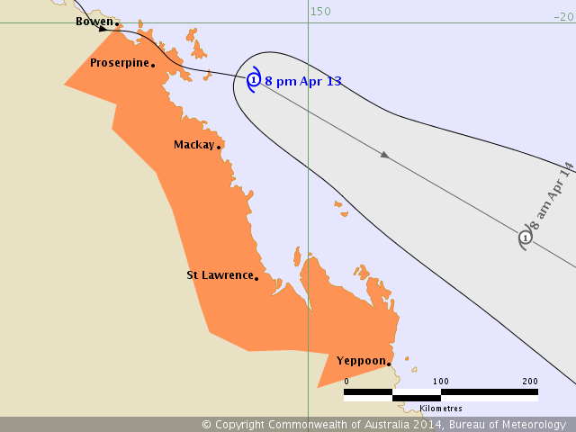
In their latest cyclone warning bulletin the Australian Government Bureau of Meteorology Tropical Cyclone Warning Centre in Brisbane revealed this forecast track for Tropical
Cyclone Ita:
The bulletin adds that:
Tropical Cyclone Ita is expected to maintain a southeast track as it crosses the Whitsunday Islands this evening before moving offshore away from the Queensland east coast overnight.
GALES with gusts to 90 kilometres per hour are possible between Bowen and Mackay this evening, before possibly extending further south to St Lawrence tonight and to Yeppoon early Monday. Gales should ease from the north tonight as the system begins to move offshore of the Queensland coast.
Heavy rainfall, which may lead to flash flooding, is expected to occur between Proserpine and Mackay, and should extend further south to Gladstone overnight. Rainfall totals of at least 100 to 200mm are likely and isolated falls to 400mm are possible.
As the system tracks near the coast abnormally high tides are expected between Proserpine and Mackay, but the sea level should not exceed the highest tide of the year. Large waves are likely along the foreshore.
People between Bowen and Yeppoon, including Mackay, should take precautions and listen to the next advice.
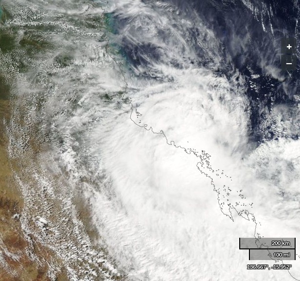
Here's how Ita looks from on high this morning, once again courtesy of NASA Worldview and the Aqua satellite:
WeatherZone reports that there have still been no fatalities in Australia, although there have been some close calls:
Power blackouts and flooding continue across much of north Queensland in the wake of Cyclone Ita, as the storm system continues moving south. The category one system, which made landfall on Friday night, is tracking south of Townsville and is heading for Mackay. Falls of 400 millimetres were expected in some parts of the coast this afternoon, with Cyclone Ita expected to maintain tropical cyclone intensity as it moves south-east over the next 24 hours. Ken Kato from the Bureau of Meteorology (BOM) says conditions are still extreme. Wind gusts up to 90 kilometres per hour are expected this evening between Ayr and Mackay.
"Our warning also covers the possibility of abnormally high tides between Townsville and Mackay," he said.
The popular holiday destinations of Airlie Beach and the Whitsunday Islands were copping the brunt of Ita on Sunday afternoon, while the weather bureau advised residents from Bowen down to Yeppoon to prepare for flash flooding. In Airlie Beach, four people had to be rescued from their car after becoming stranded. Swift water rescue crews arrived to find them sitting on the roof of the vehicle.
Meanwhile in other news from the Solomon Islands, and somewhat reminiscent of that from Haiti four years ago, the BBC reports that:
An earthquake of magnitude 7.6 has hit near the Solomon Islands, but there have been no reports of major damage or casualties.
The undersea quake was registered at a depth of 29km (18 miles), 100km (60 miles) south-east of Kira Kira.
A tsunami warning issued for the Solomon Islands, Papua New Guinea and New Caledonia was later cancelled.
Strong waves were reported after the earthquake struck at 07:14 on Sunday (20:14 GMT Saturday).
Filed under Disasters by


Leave a Comment