September 1, 2011
Hurricane Katia Heads West. Typhoon Nanmadol Kills 29 in the Far East.
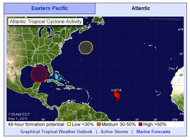
Here's the latest NHC overview of North Atlantic tropical cyclone activity. As predicted Katia is now officially a category 1 hurricane, and is still forecast to become category 3 over the coming Labor Day weekend.
According to the NHC's latest public advisory bulletin:
KATIA IS MOVING TOWARD THE WEST NEAR 20 MPH. A GENERAL MOTION TOWARD THE WEST-NORTHWEST AND A DECREASE IN FORWARD SPEED ARE EXPECTED DURING THE NEXT COUPLE OF DAYS.
MAXIMUM SUSTAINED WINDS ARE NEAR 75 MPH, WITH HIGHER GUSTS. SOME STRENGTHENING IS FORECAST DURING THE NEXT 48 HOURS AND KATIA COULD BECOME A MAJOR HURRICANE BY THE WEEKEND.
HURRICANE FORCE WINDS EXTEND OUTWARD UP TO 25 MILES FROM THE CENTER AND TROPICAL STORM FORCE WINDS EXTEND OUTWARD UP TO 125 MILES.
In addition there is a new "Area 1", color coded red, in the Gulf of Mexico. According to the NHC once more:
A TROUGH OF LOW PRESSURE LOCATED OVER THE CENTRAL GULF OF MEXICO IS PRODUCING A LARGE AREA OF CLOUDINESS AND THUNDERSTORMS AND GUSTY WINDS MAINLY ON ITS EAST SIDE. UPPER-LEVEL WINDS ARE CURRENTLY UNFAVORABLE FOR DEVELOPMENT. HOWEVER CONDITIONS ARE FORECAST TO BECOME MORE CONDUCIVE LATER TODAYAND. THIS SYSTEM HAS A HIGH CHANCE, 70 PERCENT, OF BECOMING A TROPICAL CYCLONE DURING THE NEXT 48 HOURS AS IT MOVES SLOWLY NORTHWESTWARD. INTERESTS ALONG THE ENTIRE NORTHERN GULF OF MEXICO COAST SHOULD MONITOR THE PROGRESS OF THIS DISTURBANCE.
Meanwhile in the Far East the National Disaster Risk Reduction and Management Council in the Philippines said in its latest bulletin on the effects of Typhoon Nanmadol that:
- The total number of population affected is 84,114 families (348,473 people).
- The total number of population served inside 18 evacuation centers is 725 families / 3,169 persons and outside those centers is 10,590 families / 41,437 persons.
- Casualties include 29 dead, 37 injured and 5 still missing.
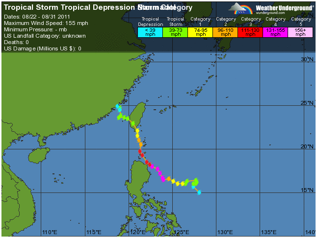
Here's the record of how Nanmadol came to produce those statistics, courtesy of Weather Underground:
As you can see, according to Weather Underground:
US damage: $0 million
However according to the NDRRMC:
Overall cost of assistance so far amounts to PhP 10,720,504.50
The initial cost of damages to infrastructure (roads and bridges, schools) and agriculture (crops, HVCC, livestock, fisheries, and Agri-infra) amounted to PhP 1,409,464,973.39
This morning the English language version of the People's Daily Online in China reports that:
Typhoon Nanmadol turned into a tropical storm over the West Pacific and strengthened into an ultra strong typhoon landing at Jinjiang city of Fujian province at 2:20 a.m. on Aug. 31.
More than 560,000 residents of Fujian province were victims of rainstorms and building collapses caused by the landing of Typhoon Nanmadol.
According to the data from the Office of Flood Control in Fujian province, more than 207,000 victims were transported out and no casualties have occurred as of 5 p.m. on Aug. 31.
Filed under Disasters by


Leave a Comment