In a break from activity in the North Atlantic, hurricane watchers like us here at econnexus.org.uk are now suddenly turning their attention to the Eastern Pacific. At 21:00 UTC last night the National Hurricane Center announced that:
More on Hurricane Jova Threatens Major Misery in Mexico
Filed under Disasters by Jim
We're a bit behind on our reporting of the progress of Hurricane Ophelia, because we've been frantically busy here in South West England launching our latest project, which is entitled "Contemporary Art in the Community". More on all that soon, but for now we must firstly apologise to Bermudan resident Tina Barnard who gave us and our other readers some extremely sound advice on how to survive if a hurricane should ever head in the direction of you and your loved ones.
More on Hurricane Ophelia Batters Bermuda
Filed under Disasters by Jim
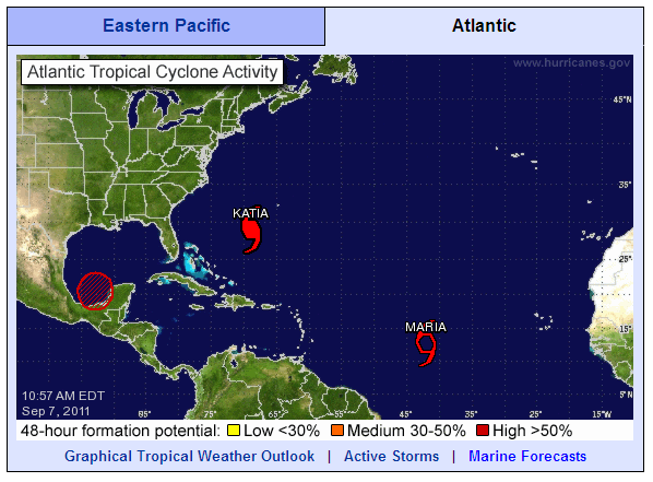
The September 7th overview of the North Atlantic from the National Hurricane Centre shows two red storms apart from Hurricane Katia:

North Atlantic tropical cyclone activity at 10:57 AM on Wednesday September 7th 2011
More on Maria Makes Her Appearance. Death Tolls Rise Elsewhere.
Filed under Disasters by Jim
Back in January the Association of Surfing Professionals announced their controversial decision to hold:
The first-ever ASP World Tour stop on the East Coast of the United States, set to take place on Long Island’s Long Beach from September 4-15. The event will offer a $1 million dollar prize purse to competitors, an amount unprecedented in professional surfing.
According to the initial press release:
More on Surfing Professionals at Long Beach Look Forward to Katia's Swell
Filed under Disasters by Jim
Here's the latest NHC overview of North Atlantic tropical cyclone activity. As predicted Katia is now officially a category 1 hurricane, and is still forecast to become category 3 over the coming Labor Day weekend.
More on Hurricane Katia Heads West. Typhoon Nanmadol Kills 29 in the Far East.
Filed under Disasters by Jim
Yesterday I became involved in a debate over on the Economist website about "hurricane hype". The article is entitled "The Storm-clouds clear" and was based on the premise that Hurricane Irene didn't turn out to be as bad as predicted. I was definitely on the side of those expressing the view that you should:
More on Katia Forecast to Become a Major Hurricane by Sunday
Filed under Disasters by Jim
In their most recent public advisory bulletin at 11:00 PM EDT last night the National Hurricane Centre said that:
IRENE BECOMES POST-TROPICAL NEAR THE U.S./CANADIAN BORDER. THE TROPICAL STORM WARNING FOR THE EAST COAST OF THE UNITED STATES HAS BEEN DISCONTINUED.
More on What Would Happen if Wall Street Were Under Water?
Filed under Disasters by Jim
In their interim 9 AM EDT public advisory bulletin the National Hurricane Centre said that:
CENTER OF IRENE MOVES OVER NEW YORK CITY
REPORTS FROM AN AIR FORCE HURRICANE HUNTER AIRCRAFT AND NATIONAL WEATHER SERVICE DOPPLER RADAR INDICATE THAT THE CENTER OF IRENE MOVED OVER NEW YORK CITY AROUND 900 AM EDT, 1300 UTC. IRENE HAS WEAKENED TO A TROPICAL STORM AND THE ESTIMATED INTENSITY AT LANDFALL WAS 65 MPH
By 11 AM the NHC were reporting that:
More on Irene Weakens to Tropical Storm Force, but Millions of Lights are Still Out
Filed under Disasters by Jim
In their 8 AM EDT public advisory bulletin the National Hurricane Centre say that the:
CENTER OF IRENE NEARING NEW YORK CITY
whilst the warnings they issued at 2 AM remain much the same. The models used by surf forecasting website MagicSeaweed suggest that the eye of the storm is currently passing almost directly over New York City, accompanied by strong onshore winds:
More on Centre of Irene Nearing New York City – Oyster Creek Reactor Shut Down
Filed under Disasters by Jim
This morning's first public advisory bulletin from the National Hurricane Center places the eye of Hurricane Irene "About 195 miles south-southwest of New York City" and warns that:
AN EXTREMELY DANGEROUS STORM SURGE WILL RAISE WATERLEVELS BY AS MUCH AS 4 TO 8 FEET ABOVE GROUND LEVEL WITHIN THE HURRICANE WARNING AREA FROM THE NORTH CAROLINA/VIRGINIA BORDER NORTHWARD TO CAPE COD INCLUDING SOUTHERN PORTIONS OF THE CHESAPEAKE BAY AND ITS TRIBUTARIES. NEAR THE COAST THE SURGE WILL BE ACCOMPANIED BY LARGE DESTRUCTIVE AND LIFE-THREATENING WAVES. HIGHER THAN NORMAL ASTRONOMICAL TIDES ARE OCCURRING THIS WEEKEND. COASTAL AND RIVER FLOODING WILL BE HIGHEST IN AREAS WHERE THE PEAK SURGE OCCURS AROUND THE TIME OF HIGH TIDE. STORM TIDE AND SURGE VALUES ARE VERY LOCATION-SPECIFIC AND USERS ARE URGED TO CONSULT PRODUCTS ISSUED BY THEIR LOCAL NATIONAL WEATHER SERVICE OFFICES.
More on Storm Surge and Tornados From Hurricane Irene Threaten New York
Filed under Disasters by Jim
